
| Memorials | : | 0 |
| Location | : | Manningham, Metropolitan Borough of Bradford, England |
| Coordinate | : | 53.8069700, -1.7723700 |
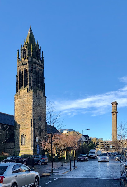
| Description | : | St. Paul’s Church was designed by ecclesiastical architects James Mallinson and Thomas Healey. The foundation stone was laid by John Hollings on the 5th November 1846, “In humble remembrance of past mercies and an earnest desire for the spiritual welfare of the district.” The builder, Mr W. Brayshaw later became Lord Mayor of Bradford (1866-7). The church is built in early-English Gothic style from York stone. It is cruciform in shape with a defined east/west axis. This feature is common to many churches and places the emphasis towards the eastern end, so that the congregation faces the direction of the coming Christ.... Read More |
frequently asked questions (FAQ):
-
Where is St Paul Churchyard?
St Paul Churchyard is located at 63 St Paul's Road Manningham, Metropolitan Borough of Bradford ,West Yorkshire , BD8 7LSEngland.
-
St Paul Churchyard cemetery's updated grave count on graveviews.com?
0 memorials
-
Where are the coordinates of the St Paul Churchyard?
Latitude: 53.8069700
Longitude: -1.7723700
Nearby Cemetories:
1. Heaton Baptist Highgate Cemetery
Heaton, Metropolitan Borough of Bradford, England
Coordinate: 53.8162500, -1.7884300
2. St Margaret's Church of England
Fritzinghall, Metropolitan Borough of Bradford, England
Coordinate: 53.8233290, -1.7730530
3. Daisy Hill Primitive Methodist Chapelyard
Bradford, Metropolitan Borough of Bradford, England
Coordinate: 53.8085600, -1.8007500
4. Toad Lane Presbyterian Chapel Graveyard
Bradford, Metropolitan Borough of Bradford, England
Coordinate: 53.7921690, -1.7543550
5. Congregational Chapel
Bradford, Metropolitan Borough of Bradford, England
Coordinate: 53.7910653, -1.7567839
6. Bradford Cathedral
Bradford, Metropolitan Borough of Bradford, England
Coordinate: 53.7953600, -1.7479800
7. Undercliffe Cemetery
Bradford, Metropolitan Borough of Bradford, England
Coordinate: 53.8040466, -1.7383590
8. East Brook Chapel
Bradford, Metropolitan Borough of Bradford, England
Coordinate: 53.7934570, -1.7464240
9. Scholemoor Cemetery and Crematorium
Bradford, Metropolitan Borough of Bradford, England
Coordinate: 53.7875404, -1.7963200
10. Windhill Cemetery
Shipley, Metropolitan Borough of Bradford, England
Coordinate: 53.8315100, -1.7694400
11. St Andrew's Undercliffe Methodist Church Graveyard
Bradford, Metropolitan Borough of Bradford, England
Coordinate: 53.8082733, -1.7303250
12. Windhill Wesleyan Methodist Burial Ground
Shipley, Metropolitan Borough of Bradford, England
Coordinate: 53.8326630, -1.7709230
13. Allerton Methodist Chapelyard
Bradford, Metropolitan Borough of Bradford, England
Coordinate: 53.8017410, -1.8158310
14. Great Horton Methodist Churchyard
Bradford, Metropolitan Borough of Bradford, England
Coordinate: 53.7813052, -1.7849559
15. Shipley Bethel Baptist Church Cemetery
Bradford, Metropolitan Borough of Bradford, England
Coordinate: 53.8343099, -1.7738626
16. St Paul Churchyard
Shipley, Metropolitan Borough of Bradford, England
Coordinate: 53.8341400, -1.7824600
17. Our Lady & St Francis of Assisi Churchyard
Bradford, Metropolitan Borough of Bradford, England
Coordinate: 53.8235700, -1.7343160
18. Friends Burial Ground
Bradford, Metropolitan Borough of Bradford, England
Coordinate: 53.7788470, -1.7747890
19. Allerton Congregational Churchyard
Bradford, Metropolitan Borough of Bradford, England
Coordinate: 53.8051410, -1.8225090
20. St Stephen Churchyard
West Bowling, Metropolitan Borough of Bradford, England
Coordinate: 53.7783440, -1.7578570
21. Norman Lane Methodist Burial Ground
Idle, Metropolitan Borough of Bradford, England
Coordinate: 53.8232117, -1.7268900
22. Our Lady of Perpetual Succour & St Cla
Bradford, Metropolitan Borough of Bradford, England
Coordinate: 53.8078740, -1.7188450
23. St Luke Churchyard
Bradford, Metropolitan Borough of Bradford, England
Coordinate: 53.8159600, -1.7200700
24. Salem Congregational Chapel Chapelyard
Bradford, Metropolitan Borough of Bradford, England
Coordinate: 53.8191010, -1.7193240