
| Memorials | : | 0 |
| Location | : | York, York Unitary Authority, England |
| Coordinate | : | 53.9609180, -1.0784710 |
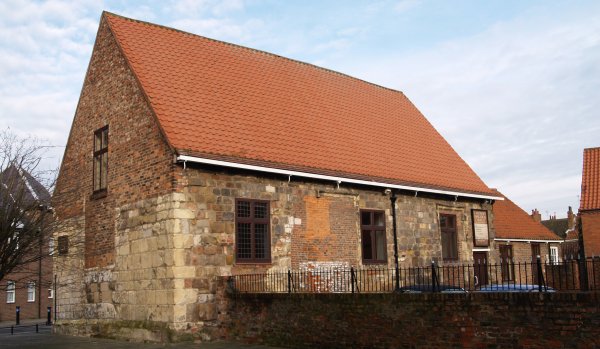
| Description | : | This medieval church was closed by order of York City Council in about 1548 and sold for secular use. By 1576 the parson of St. Saviour's was criticised for keeping his 'swyne' in St. Andrew's churchyard. Later, St. Andrews was used as stable, brothel and school, presumably not simultaneously. St Peter's School used it from 1730 to 1823. By 1924 it was the 'Gospel Hall' of the 'open' Plymouth Brethren. Today it is still used for Christian worship. |
frequently asked questions (FAQ):
-
Where is St Andrew Churchyard?
St Andrew Churchyard is located at St Andrewgate York, York Unitary Authority ,North Yorkshire ,England.
-
St Andrew Churchyard cemetery's updated grave count on graveviews.com?
0 memorials
-
Where are the coordinates of the St Andrew Churchyard?
Latitude: 53.9609180
Longitude: -1.0784710
Nearby Cemetories:
1. York Unitarian Chapelyard
York, York Unitary Authority, England
Coordinate: 53.9602950, -1.0775710
2. Holy Trinity Goodramgate Churchyard
York, York Unitary Authority, England
Coordinate: 53.9609810, -1.0804640
3. Holy Trinity Kings Court Churchyard
York, York Unitary Authority, England
Coordinate: 53.9599760, -1.0800800
4. St Saviour Churchyard
York, York Unitary Authority, England
Coordinate: 53.9596100, -1.0780000
5. Central Methodist Hall
York, York Unitary Authority, England
Coordinate: 53.9594090, -1.0788330
6. St Crux Hungate Burial Ground
York, York Unitary Authority, England
Coordinate: 53.9593540, -1.0774470
7. St Cuthbert Churchyard
York, York Unitary Authority, England
Coordinate: 53.9609180, -1.0752310
8. All Saints Peasholme (Defunct)
York, York Unitary Authority, England
Coordinate: 53.9597200, -1.0759220
9. St Crux Churchyard
York, York Unitary Authority, England
Coordinate: 53.9589890, -1.0795460
10. St Sampson Churchyard
York, York Unitary Authority, England
Coordinate: 53.9597440, -1.0813060
11. St John Churchyard
York, York Unitary Authority, England
Coordinate: 53.9591850, -1.0761680
12. York Minster
York, York Unitary Authority, England
Coordinate: 53.9619440, -1.0819440
13. St Maurice Churchyard
York, York Unitary Authority, England
Coordinate: 53.9633340, -1.0782010
14. St Michael le Belfrey Churchyard
York, York Unitary Authority, England
Coordinate: 53.9618620, -1.0829730
15. St Helen Davygate Church Cemetery
York, York Unitary Authority, England
Coordinate: 53.9596460, -1.0830390
16. All Saints Pavement Churchyard
York, York Unitary Authority, England
Coordinate: 53.9581090, -1.0808820
17. St Peter the Little (Defunct)
York, York Unitary Authority, England
Coordinate: 53.9585310, -1.0821170
18. St Helen Churchyard
York, York Unitary Authority, England
Coordinate: 53.9603030, -1.0841970
19. St Wilfred Churchyard
York, York Unitary Authority, England
Coordinate: 53.9610550, -1.0848990
20. St Martin le Grand Churchyard
York, York Unitary Authority, England
Coordinate: 53.9593870, -1.0843800
21. Saint Peter's
York, York Unitary Authority, England
Coordinate: 53.9577400, -1.0822600
22. Carmelite Friary of York (Defunct)
York, York Unitary Authority, England
Coordinate: 53.9577020, -1.0822860
23. St Michael Churchyard
York, York Unitary Authority, England
Coordinate: 53.9577900, -1.0825600
24. St. Mary Castlegate Churchyard
York, York Unitary Authority, England
Coordinate: 53.9570800, -1.0804370