
| Memorials | : | 0 |
| Location | : | York, York Unitary Authority, England |
| Coordinate | : | 53.9618620, -1.0829730 |
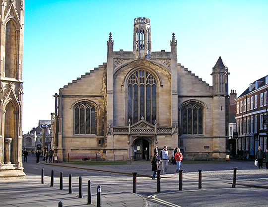
| Description | : | The present church building was built between 1525 and 1536 and replaced a church that dated back to at least 1294. The church is famous for being the place where Guy Fawkes was christened on 16 April 1570. Fawkes was christened an Anglican but later converted to Catholicism which led to the failed 1605 Gunpowder Plot Burial registers for St Michael le Belfrey parish cover the period 1565 to 1854. These have been deposited with the Borthwick Institute for Archives, University of York, Heslington, York, YO10 5DD. Like all other church burial locations within the City of York, the St... Read More |
frequently asked questions (FAQ):
-
Where is St Michael le Belfrey Churchyard?
St Michael le Belfrey Churchyard is located at York, York Unitary Authority ,North Yorkshire ,England.
-
St Michael le Belfrey Churchyard cemetery's updated grave count on graveviews.com?
0 memorials
-
Where are the coordinates of the St Michael le Belfrey Churchyard?
Latitude: 53.9618620
Longitude: -1.0829730
Nearby Cemetories:
1. York Minster
York, York Unitary Authority, England
Coordinate: 53.9619440, -1.0819440
2. St Wilfred Churchyard
York, York Unitary Authority, England
Coordinate: 53.9610550, -1.0848990
3. St Helen Churchyard
York, York Unitary Authority, England
Coordinate: 53.9603030, -1.0841970
4. Holy Trinity Goodramgate Churchyard
York, York Unitary Authority, England
Coordinate: 53.9609810, -1.0804640
5. Lendal Congregational Chapel
York, York Unitary Authority, England
Coordinate: 53.9606360, -1.0860970
6. St Helen Davygate Church Cemetery
York, York Unitary Authority, England
Coordinate: 53.9596460, -1.0830390
7. St Giles Churchyard
York, York Unitary Authority, England
Coordinate: 53.9640010, -1.0843930
8. St Sampson Churchyard
York, York Unitary Authority, England
Coordinate: 53.9597440, -1.0813060
9. Augustinian Friary, York (Nonextant)
York, York Unitary Authority, England
Coordinate: 53.9601683, -1.0860521
10. Holy Trinity Kings Court Churchyard
York, York Unitary Authority, England
Coordinate: 53.9599760, -1.0800800
11. St Martin le Grand Churchyard
York, York Unitary Authority, England
Coordinate: 53.9593870, -1.0843800
12. St Andrew Churchyard
York, York Unitary Authority, England
Coordinate: 53.9609180, -1.0784710
13. St Maurice Churchyard
York, York Unitary Authority, England
Coordinate: 53.9633340, -1.0782010
14. Abbey of St Mary (defunct)
York, York Unitary Authority, England
Coordinate: 53.9620290, -1.0883600
15. St Peter the Little (Defunct)
York, York Unitary Authority, England
Coordinate: 53.9585310, -1.0821170
16. Central Methodist Hall
York, York Unitary Authority, England
Coordinate: 53.9594090, -1.0788330
17. St Crux Churchyard
York, York Unitary Authority, England
Coordinate: 53.9589890, -1.0795460
18. York Unitarian Chapelyard
York, York Unitary Authority, England
Coordinate: 53.9602950, -1.0775710
19. St Olave Churchyard
York, York Unitary Authority, England
Coordinate: 53.9622570, -1.0891560
20. St Saviour Churchyard
York, York Unitary Authority, England
Coordinate: 53.9596100, -1.0780000
21. Blackfriars Abbey Church (Defunct)
York, York Unitary Authority, England
Coordinate: 53.9594100, -1.0880900
22. All Saints North Street Churchyard
York, York Unitary Authority, England
Coordinate: 53.9584400, -1.0862400
23. All Saints Pavement Churchyard
York, York Unitary Authority, England
Coordinate: 53.9581090, -1.0808820
24. St Michael Churchyard
York, York Unitary Authority, England
Coordinate: 53.9577900, -1.0825600