
| Memorials | : | 47 |
| Location | : | Melton, Suffolk Coastal District, England |
| Coordinate | : | 52.1169050, 1.3321920 |
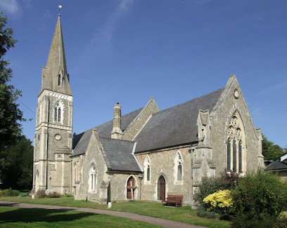
| Description | : | St Audry's Hospital was originally the Melton House of Industry for the relief of the poor and later became The Suffolk County Asylum for Pauper Lunatics in 1829. The asylum became known as St Audry's Hospital for Mental Diseases in 1917. St Audry's Hospital was closed in 1993. Most patients were buried in the villages from whence they came, however, some patients were interred in the burial ground at the hospital. Grave sites were initially marked with a metal cross with a number on it. More recent graves were marked with headstones. No patients have been buried... Read More |
frequently asked questions (FAQ):
-
Where is St Audry's Hospital Chapel Burial Grounds?
St Audry's Hospital Chapel Burial Grounds is located at Melton, Suffolk Coastal District ,Suffolk ,England.
-
St Audry's Hospital Chapel Burial Grounds cemetery's updated grave count on graveviews.com?
46 memorials
-
Where are the coordinates of the St Audry's Hospital Chapel Burial Grounds?
Latitude: 52.1169050
Longitude: 1.3321920
Nearby Cemetories:
1. St Andrew the Apostle Churchyard
Melton, Suffolk Coastal District, England
Coordinate: 52.1065910, 1.3336210
2. Melton Old Churchyard
Melton, Suffolk Coastal District, England
Coordinate: 52.1125150, 1.3505240
3. St Andrew's Churchyard
Bredfield, Suffolk Coastal District, England
Coordinate: 52.1288710, 1.3129440
4. St Edmund's Churchyard
Bromeswell, Suffolk Coastal District, England
Coordinate: 52.1064300, 1.3617740
5. St Michael Churchyard
Boulge, Suffolk Coastal District, England
Coordinate: 52.1280920, 1.2918290
6. St. Peter and St. Paul Churchyard
Pettistree, Suffolk Coastal District, England
Coordinate: 52.1410880, 1.3525270
7. St Andrew Churchyard
Hasketon, Suffolk Coastal District, England
Coordinate: 52.1063910, 1.2845520
8. All Saints Church Burial Ground
Eyke, Suffolk Coastal District, England
Coordinate: 52.1156810, 1.3832240
9. Saint Mary Churchyard
Dallinghoo, Suffolk Coastal District, England
Coordinate: 52.1465220, 1.3109100
10. St Gregory the Great Churchyard
Rendlesham, Suffolk Coastal District, England
Coordinate: 52.1247080, 1.3952270
11. Campsey Priory
Campsey Ash, Suffolk Coastal District, England
Coordinate: 52.1396150, 1.3866000
12. All Saints Church Cemetery
Debach, Suffolk Coastal District, England
Coordinate: 52.1421030, 1.2760230
13. Charsfield Baptist Church
Charsfield, Suffolk Coastal District, England
Coordinate: 52.1590750, 1.3005590
14. St. Mary's Churchyard
Martlesham, Suffolk Coastal District, England
Coordinate: 52.0742350, 1.3000490
15. St Peter Churchyard
Charsfield, Suffolk Coastal District, England
Coordinate: 52.1614360, 1.2945540
16. Baptist Chapelyard
Grundisburgh, Suffolk Coastal District, England
Coordinate: 52.1058380, 1.2499810
17. All Saints Churchyard
Sutton, Suffolk Coastal District, England
Coordinate: 52.0682690, 1.3636990
18. St Botolph Churchyard
Burgh, Suffolk Coastal District, England
Coordinate: 52.1239800, 1.2470740
19. St. Mary's Churchyard
Great Bealings, Suffolk Coastal District, England
Coordinate: 52.0930240, 1.2554220
20. St Mary the Virgin
Grundisburgh, Suffolk Coastal District, England
Coordinate: 52.1130840, 1.2460330
21. St Mary Churchyard
Clopton, Suffolk Coastal District, England
Coordinate: 52.1269860, 1.2431221
22. St John the Baptist Churchyard
Campsey Ash, Suffolk Coastal District, England
Coordinate: 52.1520000, 1.4040000
23. All Saints Churchyard
Little Bealings, Suffolk Coastal District, England
Coordinate: 52.0854520, 1.2525230
24. All Saints
Little Bealings, Suffolk Coastal District, England
Coordinate: 52.0854660, 1.2522380