
| Memorials | : | 4 |
| Location | : | Holborn, London Borough of Camden, England |
| Website | : | www.stgilesonline.org |
| Coordinate | : | 51.5153070, -0.1285300 |
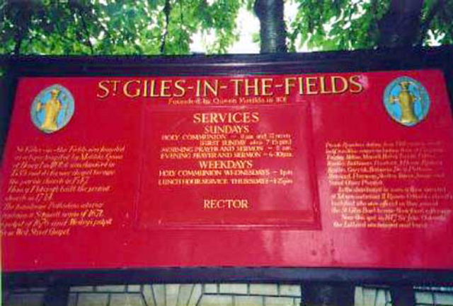
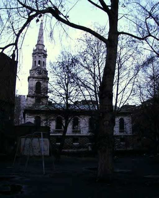
| Description | : | St. Giles-in-the-Fields is one of London's hidden churches. The Church which is an outstandingly beautiful building was built in the Palladian style in 1734. St Giles in the Fields is a church in the London Borough of Camden, in the West End. It is close to the Centre Point office tower and the Tottenham Court Road tube station. The church is part of the Diocese of London within the Church of England. St Giles is known as 'The Poets' Church'. Poet John Milton's daughter Mary was baptised in the Gothic brick building in 1647 and the Poetry Society holds its annual... Read More |
frequently asked questions (FAQ):
-
Where is St Giles in the Fields Churchyard?
St Giles in the Fields Churchyard is located at 60 St Giles High Street Holborn, London Borough of Camden ,Greater London , WC2H 8LGEngland.
-
St Giles in the Fields Churchyard cemetery's updated grave count on graveviews.com?
4 memorials
-
Where are the coordinates of the St Giles in the Fields Churchyard?
Latitude: 51.5153070
Longitude: -0.1285300
Nearby Cemetories:
1. St. George's Churchyard
Bloomsbury, City of Westminster, England
Coordinate: 51.5177160, -0.1248090
2. St. Anne's Church
London, City of London, England
Coordinate: 51.5124321, -0.1318976
3. St Anne Churchyard
Soho, City of Westminster, England
Coordinate: 51.5123910, -0.1322610
4. British Museum
London, City of London, England
Coordinate: 51.5190500, -0.1271778
5. St. Paul's Churchyard
Covent Garden, London Borough of Camden, England
Coordinate: 51.5114594, -0.1239310
6. St. Martin-in-the-Fields Churchyard
Westminster, City of Westminster, England
Coordinate: 51.5087624, -0.1269620
7. Whitefield’s Tabernacle and Burial Ground
London Borough of Camden, England
Coordinate: 51.5208990, -0.1350780
8. Sir John Soane's Museum
Holborn, London Borough of Camden, England
Coordinate: 51.5170370, -0.1174070
9. Savoy Chapel Churchyard
Strand, City of Westminster, England
Coordinate: 51.5105360, -0.1199210
10. London Palladium
Soho, City of Westminster, England
Coordinate: 51.5146000, -0.1404500
11. St. Bartholomew-by-the-Exchange
London, City of London, England
Coordinate: 51.5082830, -0.1333593
12. Portugal Street Burial Ground (Defunct)
London, City of London, England
Coordinate: 51.5142280, -0.1162410
13. St Mary le Strand Church
Strand, City of Westminster, England
Coordinate: 51.5121540, -0.1169360
14. Royal College of Surgeons of England
City of Westminster, England
Coordinate: 51.5152780, -0.1158330
15. St. George the Martyr Church
Holborn, London Borough of Camden, England
Coordinate: 51.5221490, -0.1221370
16. Great Ormond Street Hospital for Children
London, City of London, England
Coordinate: 51.5218890, -0.1206750
17. St. James Churchyard
Piccadilly, City of Westminster, England
Coordinate: 51.5085907, -0.1367360
18. Lincoln's Inn
Holborn, London Borough of Camden, England
Coordinate: 51.5161310, -0.1136610
19. St Clement Danes Churchyard
City of Westminster, England
Coordinate: 51.5131070, -0.1138980
20. St. George Churchyard
Mayfair, City of Westminster, England
Coordinate: 51.5125140, -0.1429070
21. Lincoln's Inn Chapel
Holborn, London Borough of Camden, England
Coordinate: 51.5164400, -0.1132400
22. The Foundling Hospital
Bloomsbury, London Borough of Camden, England
Coordinate: 51.5250140, -0.1201210
23. University College London
Bloomsbury, City of Westminster, England
Coordinate: 51.5265200, -0.1310080
24. Marlborough House
City of Westminster, England
Coordinate: 51.5049710, -0.1363050