
| Memorials | : | 2 |
| Location | : | Old Stratford, South Northamptonshire Borough, England |
| Website | : | www.htdchurch.org/st-guthlac-s |
| Coordinate | : | 52.0481170, -0.8634000 |
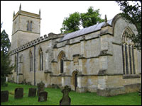
| Description | : | PHOTO CREDIT: The Wolverton and District Archaeological and Historical Society. "By kind permission of Roger Emery" http://www.mkheritage.co.uk/wdahs/pass/docs/church/gravestones.html Date accessed: 25 Mar 2012. MEMORIAL AND GRAVESTONE INSCRIPTIONS: "by kind permission of Northamptonshire Family History Society" URL: http://www.mkheritage.co.uk/wdahs/pass/docs/church/gravestones.html Date accessed: 22 March 2012. CHURCH & CHURCHYARD CEMETERY DESCRIPTION: The St Guthlac's Passenham Church and Churchyard Cemetery are next to the Passenham Manor House and the Passenham Manor Farm. In addition to headstones in their original positions in the churchyard, a line of headstones and footstones have been removed and are leaning against the east wall of the churchyard, many with illegible inscriptions. Some burials are made within the church itself.... Read More |
frequently asked questions (FAQ):
-
Where is St Guthlac's Church Passenham?
St Guthlac's Church Passenham is located at Old Stratford, South Northamptonshire Borough ,Northamptonshire ,England.
-
St Guthlac's Church Passenham cemetery's updated grave count on graveviews.com?
1 memorials
-
Where are the coordinates of the St Guthlac's Church Passenham?
Latitude: 52.0481170
Longitude: -0.8634000
Nearby Cemetories:
1. St. Guthlac's Churchyard
Milton Keynes Borough, England
Coordinate: 52.0483770, -0.8634780
2. Calverton Road Cemetery
Stony Stratford, Milton Keynes Borough, England
Coordinate: 52.0534300, -0.8511800
3. All Saints Churchyard
Calverton, Milton Keynes Borough, England
Coordinate: 52.0439000, -0.8492000
4. St. Mary and St. Giles Churchyard
Stony Stratford, Milton Keynes Borough, England
Coordinate: 52.0569580, -0.8535910
5. St Mary Magdalen Churchyard
Stony Stratford, Milton Keynes Borough, England
Coordinate: 52.0587470, -0.8550560
6. London Road Cemetery
Stony Stratford, Milton Keynes Borough, England
Coordinate: 52.0529290, -0.8439400
7. Holy Trinity Churchyard
Deanshanger, South Northamptonshire Borough, England
Coordinate: 52.0493600, -0.8907600
8. Assumption of the Blessed Virgin Mary Church
Beachampton, Aylesbury Vale District, England
Coordinate: 52.0267000, -0.8784000
9. Holy Trinity Churchyard
Wolverton, Milton Keynes Borough, England
Coordinate: 52.0642500, -0.8297700
10. St. Peter & St. Paul's Parish Churchyard
Cosgrove, South Northamptonshire Borough, England
Coordinate: 52.0748600, -0.8474600
11. Wolverton Cemetery
Wolverton, Milton Keynes Borough, England
Coordinate: 52.0578540, -0.8184220
12. St John the Evangelist Churchyard
Wicken, South Northamptonshire Borough, England
Coordinate: 52.0489000, -0.9149000
13. Potterspury Cemetery
Potterspury, South Northamptonshire Borough, England
Coordinate: 52.0803020, -0.8898052
14. St George the Martyr Churchyard
Wolverton, Milton Keynes Borough, England
Coordinate: 52.0622410, -0.8075220
15. St. Michael & All Angels Churchyard
Thornton, Aylesbury Vale District, England
Coordinate: 52.0194400, -0.9055200
16. United Reformed Church
Potterspury, South Northamptonshire Borough, England
Coordinate: 52.0836703, -0.8887879
17. Crownhill Cemetery and Crematorium
Milton Keynes, Milton Keynes Borough, England
Coordinate: 52.0321870, -0.8054640
18. St Lawrence's Churchyard
Bradwell, Milton Keynes Borough, England
Coordinate: 52.0474500, -0.7891000
19. St. James Ecumenical Churchyard
New Bradwell, Milton Keynes Borough, England
Coordinate: 52.0651300, -0.7935050
20. St. Simon & St. Jude Churchyard
Castlethorpe, Milton Keynes Borough, England
Coordinate: 52.0931117, -0.8349450
21. All Saints Churchyard
Nash, Aylesbury Vale District, England
Coordinate: 51.9990300, -0.8634000
22. St Leonards Church
Yardley Gobion, South Northamptonshire Borough, England
Coordinate: 52.0962081, -0.8844584
23. Assumption of the Blessed Virgin Mary Churchyard
Leckhampstead, Aylesbury Vale District, England
Coordinate: 52.0349200, -0.9426000
24. St. Mary's Churchyard
Milton Keynes Borough, England
Coordinate: 52.0769923, -0.7933094