
| Memorials | : | 1699 |
| Location | : | Burnley, Burnley Borough, England |
| Coordinate | : | 53.7898290, -2.2574200 |
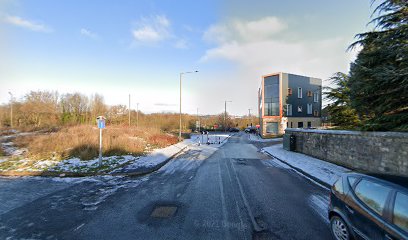
| Description | : | CHURCH OF THE HOLY TRINITY (Church of England), Habergham Eaves Located in the parish and township of Habergham Eaves in the district of Burnley, Holy Trinity is listed as a Grade II historic building by the National Heritage Trust. Completed and consecrated in 1836, it's chancel was enlarged in 1871-72 and a vestry added. Closed in 1989, the church was declared redundant the following year and its benefice united with that of St. Matthew, Burnley. After its closure, it was damaged by fire but restored and converted into flats. The churchyard was closed to burials in 1965. Many of the... Read More |
frequently asked questions (FAQ):
-
Where is Holy Trinity Churchyard?
Holy Trinity Churchyard is located at Accrington Rd Burnley, Burnley Borough ,Lancashire ,England.
-
Holy Trinity Churchyard cemetery's updated grave count on graveviews.com?
106 memorials
-
Where are the coordinates of the Holy Trinity Churchyard?
Latitude: 53.7898290
Longitude: -2.2574200
Nearby Cemetories:
1. St. James' Churchyard
Burnley, Burnley Borough, England
Coordinate: 53.7905590, -2.2458280
2. St. Peter's Churchyard
Burnley, Burnley Borough, England
Coordinate: 53.7924450, -2.2394890
3. Ebenezer Baptist Chapel Chapelyard
Burnley, Burnley Borough, England
Coordinate: 53.7975120, -2.2397260
4. Burnley Cemetery
Burnley, Burnley Borough, England
Coordinate: 53.7821730, -2.2795070
5. Burnley Crematorium
Burnley, Burnley Borough, England
Coordinate: 53.7821730, -2.2795070
6. All Saints Churchyard
Habergham Eaves, Burnley Borough, England
Coordinate: 53.7971060, -2.2913770
7. St. John's Cemetery
Padiham, Burnley Borough, England
Coordinate: 53.7948720, -2.3145290
8. St Margaret Churchyard
Hapton, Burnley Borough, England
Coordinate: 53.7802400, -2.3169230
9. St. Leonard's Churchyard
Padiham, Burnley Borough, England
Coordinate: 53.8022600, -2.3164300
10. Wesleyan Methodist Chapel Chapelyard
Padiham, Burnley Borough, England
Coordinate: 53.8018980, -2.3181730
11. St. James' Churchyard
Briercliffe, Burnley Borough, England
Coordinate: 53.8107700, -2.2031800
12. St Leonard Churchyard Extension
Padiham, Burnley Borough, England
Coordinate: 53.7991800, -2.3222000
13. St John Churchyard
Higham, Pendle Borough, England
Coordinate: 53.8251420, -2.2898120
14. St. John the Evangelist Churchyard
Worsthorne, Burnley Borough, England
Coordinate: 53.7877640, -2.1887420
15. Marsden Friends Burial Ground
Marsden, Metropolitan Borough of Kirklees, England
Coordinate: 53.8241910, -2.2197410
16. St. Anne Churchyard
Fence, Pendle Borough, England
Coordinate: 53.8304372, -2.2679552
17. Haggate Baptist Church Burial Ground
Burnley Borough, England
Coordinate: 53.8145048, -2.1960725
18. Wheatley Lane Methodist Churchyard
Fence, Pendle Borough, England
Coordinate: 53.8341457, -2.2596202
19. St. Paul's Churchyard
Nelson, Pendle Borough, England
Coordinate: 53.8289250, -2.2157520
20. Providence Free United Methodist Graveyard
Crawshawbooth, Rossendale Borough, England
Coordinate: 53.7442070, -2.2825700
21. Hill Lane Baptist Church Churchyard
Briercliffe, Burnley Borough, England
Coordinate: 53.8161467, -2.1875368
22. Wheatley Lane Inghamite Church Churchyard
Wheatley Lane, Pendle Borough, England
Coordinate: 53.8412800, -2.2457100
23. St James Church
Altham, Hyndburn Borough, England
Coordinate: 53.7928940, -2.3465250
24. St. John the Divine Churchyard
Cliviger, Burnley Borough, England
Coordinate: 53.7533610, -2.1895090