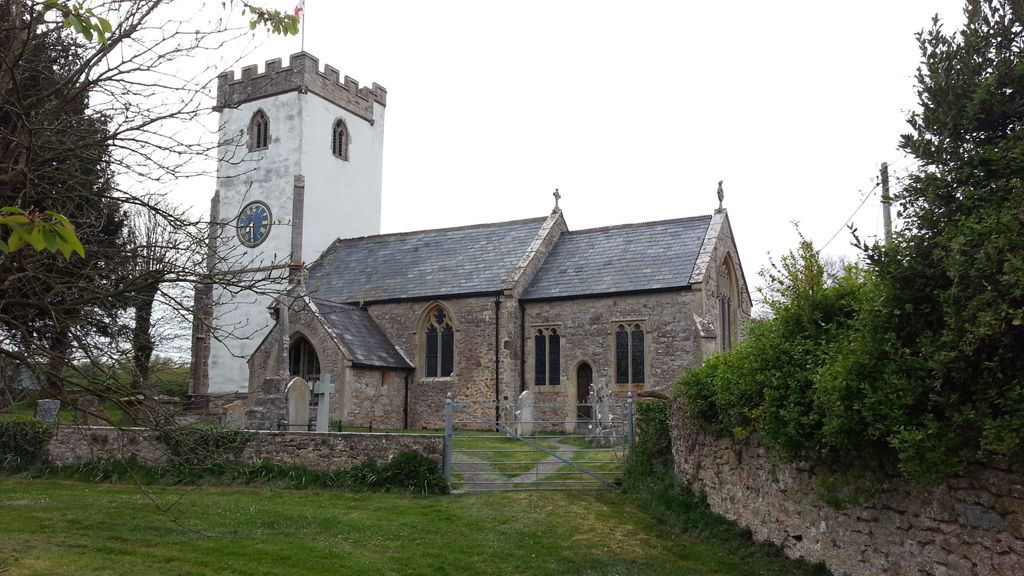
| Memorials | : | 29 |
| Location | : | Fiddington, Sedgemoor District, England |
| Coordinate | : | 51.1591640, -3.1229530 |
| Description | : | This Grade II* listed Church still has traces of it's 11th/12th century herringbone masonry on the south walls of the nave and chancel. Dedicated by the 14th century, it comprised a nave with north aisle and south porch, chancel with north vestry, a west tower, 15th century bench ends, Jacobean pulpit, font with Jacobean cover. The chancel arch is 14th century and possibly 16th for the wagon roofs. Repair work following the storm damage of 1729 was included in the additional work between 1727-1732. Restoration in 1860 included the addition of a north aisle, rebuild of... Read More |
frequently asked questions (FAQ):
-
Where is St. Martin's Churchyard?
St. Martin's Churchyard is located at Church Road Fiddington, Sedgemoor District ,Somerset , TA5 1JGEngland.
-
St. Martin's Churchyard cemetery's updated grave count on graveviews.com?
29 memorials
-
Where are the coordinates of the St. Martin's Churchyard?
Latitude: 51.1591640
Longitude: -3.1229530
Nearby Cemetories:
1. St. Mary's Churchyard
Nether Stowey, Sedgemoor District, England
Coordinate: 51.1502280, -3.1494270
2. Nether Stowey Cemetery
Nether Stowey, Sedgemoor District, England
Coordinate: 51.1498667, -3.1530087
3. Stogursey Extension Cemetery
Stogursey, West Somerset District, England
Coordinate: 51.1793740, -3.1398040
4. St Andrew Churchyard
Stogursey, West Somerset District, England
Coordinate: 51.1795900, -3.1392800
5. St Peter and St Paul Churchyard
Over Stowey, Sedgemoor District, England
Coordinate: 51.1399680, -3.1656040
6. Over Stowey Cemetery
Over Stowey, Sedgemoor District, England
Coordinate: 51.1404020, -3.1661850
7. Saint Margaret's Churchyard
Spaxton, Sedgemoor District, England
Coordinate: 51.1273090, -3.1087000
8. Charlynch Church of Saint Mary
Spaxton, Sedgemoor District, England
Coordinate: 51.1342600, -3.0879100
9. Spaxton Extension Cemetery
Spaxton, Sedgemoor District, England
Coordinate: 51.1267650, -3.1082920
10. Cannington Cemetery
Cannington, Sedgemoor District, England
Coordinate: 51.1500620, -3.0697070
11. St.Mary Magdalene
Stockland Bristol, Sedgemoor District, England
Coordinate: 51.1867260, -3.0886950
12. All Saints Churchyard
Otterhampton, Sedgemoor District, England
Coordinate: 51.1829540, -3.0796420
13. Otterhampton Extension Cemetery
Otterhampton, Sedgemoor District, England
Coordinate: 51.1828490, -3.0791630
14. Burton Baptist Chapel
Stogursey, West Somerset District, England
Coordinate: 51.1910560, -3.1560340
15. St. Mary's Churchyard
Stringston, West Somerset District, England
Coordinate: 51.1748960, -3.1795460
16. Blessed Virgin Mary Churchyard
Cannington, Sedgemoor District, England
Coordinate: 51.1500970, -3.0622850
17. All Saints Churchyard
Dodington, West Somerset District, England
Coordinate: 51.1583770, -3.1854620
18. All Saints Churchyard
Aisholt, Sedgemoor District, England
Coordinate: 51.1142070, -3.1532890
19. St. Michael's Churchyard
Enmore, Sedgemoor District, England
Coordinate: 51.1110830, -3.0872790
20. St. Mary's Churchyard
Holford, West Somerset District, England
Coordinate: 51.1627900, -3.2074238
21. St. Nicholas's Churchyard
Holford, West Somerset District, England
Coordinate: 51.1902700, -3.1949170
22. St. Andrew's Churchyard
Lilstock, West Somerset District, England
Coordinate: 51.1971070, -3.1936420
23. St Hugh's Church
Durleigh, Sedgemoor District, England
Coordinate: 51.1198090, -3.0375260
24. Quantock Road Cemetery
Bridgwater, Sedgemoor District, England
Coordinate: 51.1284270, -3.0285630

