
| Memorials | : | 0 |
| Location | : | Swaffham Bulbeck, East Cambridgeshire District, England |
| Coordinate | : | 52.2363700, 0.2762500 |
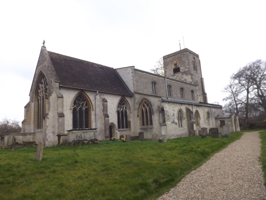
| Description | : | Swaffham Bulbeck is a parish in the ancient Hundred of Stain, 6 miles south-west of Newmarket, and the same distance from Six-Mile-Bottom railway station. Swaffham Bulbeck is located about 8 miles from the city of Cambridge, and 6 miles from the famous horse-racing town of Newmarket. The parish of Swaffham Bulbeck is part of the Diocese of Ely and the Deanery of Fordham and Quy. The benefice consists of five parishes, Swaffham Bulbeck, Swaffham Prior, Bottisham, Lode and Quy. The village is situated on Swaffham Lode, a navigable cut or canal, from the river Cam. It is located just beyond the end... Read More |
frequently asked questions (FAQ):
-
Where is St Mary Churchyard?
St Mary Churchyard is located at High Street Swaffham Bulbeck, East Cambridgeshire District ,Cambridgeshire , CB25 0LXEngland.
-
St Mary Churchyard cemetery's updated grave count on graveviews.com?
0 memorials
-
Where are the coordinates of the St Mary Churchyard?
Latitude: 52.2363700
Longitude: 0.2762500
Nearby Cemetories:
1. Swaffham Bulbeck Cemetery
Swaffham Bulbeck, East Cambridgeshire District, England
Coordinate: 52.2404330, 0.2794270
2. Bottisham Cemetery
Bottisham, East Cambridgeshire District, England
Coordinate: 52.2217100, 0.2620800
3. Holy Trinity Churchyard
Bottisham, East Cambridgeshire District, England
Coordinate: 52.2207558, 0.2609813
4. Swaffham Prior Cemetery
Swaffham Prior, East Cambridgeshire District, England
Coordinate: 52.2506740, 0.2962160
5. St. Mary the Virgin Churchyard
Swaffham Prior, East Cambridgeshire District, England
Coordinate: 52.2510981, 0.2962463
6. Saint James Churchyard
Lode, East Cambridgeshire District, England
Coordinate: 52.2408700, 0.2447000
7. Lode Baptist Chapel
Lode, East Cambridgeshire District, England
Coordinate: 52.2409600, 0.2436900
8. St. Mary's Churchyard
Lakenheath, Forest Heath District, England
Coordinate: 52.2457189, 0.3143020
9. St Nicholas Churchyard
Great Wilbraham, South Cambridgeshire District, England
Coordinate: 52.1963890, 0.2638060
10. St Mary the Virgin Churchyard
Burwell, East Cambridgeshire District, England
Coordinate: 52.2697130, 0.3280880
11. St. George's Churchyard
Six Mile Bottom, South Cambridgeshire District, England
Coordinate: 52.1861900, 0.3117400
12. National Stud Equine Cemetery
Newmarket, Forest Heath District, England
Coordinate: 52.2272000, 0.3644800
13. Burwell Cemetery
Burwell, East Cambridgeshire District, England
Coordinate: 52.2802890, 0.3337960
14. St. Peter Churchyard
Horningsea, South Cambridgeshire District, England
Coordinate: 52.2418000, 0.1846800
15. Horningsea Cemetery
Horningsea, South Cambridgeshire District, England
Coordinate: 52.2358100, 0.1832900
16. Burwell Baptist Churchyard
Burwell, East Cambridgeshire District, England
Coordinate: 52.2852900, 0.3255400
17. Waterbeach Baptist Church
Waterbeach, South Cambridgeshire District, England
Coordinate: 52.2652204, 0.1913064
18. Exning New Cemetery
Exning, Forest Heath District, England
Coordinate: 52.2600090, 0.3665360
19. St Vigor & All Saints Churchyard
Fulbourn, South Cambridgeshire District, England
Coordinate: 52.1832222, 0.2231111
20. All Saints Churchyard
Teversham, South Cambridgeshire District, England
Coordinate: 52.2046650, 0.1880510
21. Waterbeach Cemetery
Waterbeach, South Cambridgeshire District, England
Coordinate: 52.2735800, 0.1888600
22. Fulbourn United Reformed Church
Fulbourn, South Cambridgeshire District, England
Coordinate: 52.1793500, 0.2232800
23. St Martin Churchyard
Exning, Forest Heath District, England
Coordinate: 52.2639000, 0.3745000
24. Fen Ditton Cemetery
Fen Ditton, South Cambridgeshire District, England
Coordinate: 52.2233300, 0.1696700