
| Memorials | : | 0 |
| Location | : | Morley, Metropolitan Borough of Leeds, England |
| Coordinate | : | 53.7477900, -1.6015600 |
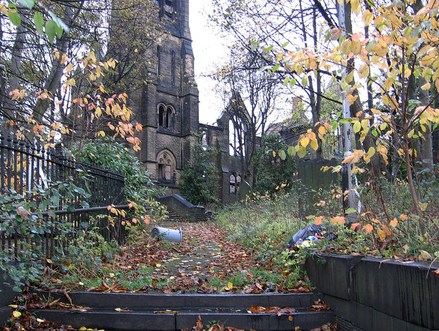
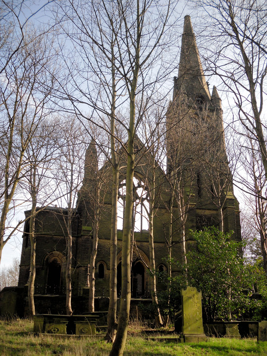
| Description | : | Church of St. Mary in the Wood, also known as the "Old Chapel." "The history of St. Mary's in the Wood covers over 1,000 years. It is recorded in the Domesday Book of 1086. On 25 September 1650, a lease was granted to local Presbyterians for 500 years...It is the only instance in England or Wales of an ancient Episcopal place of Worship which did not return to the Established church at the Restoration of the Stuarts in 1660." |
frequently asked questions (FAQ):
-
Where is St Mary in the Wood Churchyard?
St Mary in the Wood Churchyard is located at Commercial Street Morley, Metropolitan Borough of Leeds ,West Yorkshire , LS27 8HYEngland.
-
St Mary in the Wood Churchyard cemetery's updated grave count on graveviews.com?
0 memorials
-
Where are the coordinates of the St Mary in the Wood Churchyard?
Latitude: 53.7477900
Longitude: -1.6015600
Nearby Cemetories:
1. Banks Hill Wesleyan Methodist Chapelyard
Morley, Metropolitan Borough of Leeds, England
Coordinate: 53.7495480, -1.6000880
2. Rehoboth Independent Chapel Burial Ground
Morley, Metropolitan Borough of Leeds, England
Coordinate: 53.7488403, -1.6048510
3. Zion Independent Chapel Cemetery
Morley, Metropolitan Borough of Leeds, England
Coordinate: 53.7447500, -1.6021900
4. Central Methodist Churchyard
Morley, Metropolitan Borough of Leeds, England
Coordinate: 53.7440900, -1.6008100
5. St Peter Churchyard
Morley, Metropolitan Borough of Leeds, England
Coordinate: 53.7527430, -1.6006510
6. Morley Cemetery
Morley, Metropolitan Borough of Leeds, England
Coordinate: 53.7458687, -1.6174150
7. St. Andrew's Parish Church, Bruntcliffe
Morley, Metropolitan Borough of Leeds, England
Coordinate: 53.7394270, -1.6162170
8. Daffil Chapel Cemetery
Churwell, Metropolitan Borough of Leeds, England
Coordinate: 53.7602100, -1.5921100
9. Topcliffe Congregational Chapelyard
Tingley, Metropolitan Borough of Leeds, England
Coordinate: 53.7394380, -1.5811710
10. United Hebrew Congregation Cemetery
Gildersome, Metropolitan Borough of Leeds, England
Coordinate: 53.7682170, -1.5974320
11. Friends Burial Ground
Gildersome, Metropolitan Borough of Leeds, England
Coordinate: 53.7574920, -1.6325950
12. St. Peter's Churchyard
Gildersome, Metropolitan Borough of Leeds, England
Coordinate: 53.7592020, -1.6335180
13. Gildersome Cemetery
Gildersome, Metropolitan Borough of Leeds, England
Coordinate: 53.7589030, -1.6345120
14. Beth Hamedrash Hagadol Jewish Cemetery
Gildersome, Metropolitan Borough of Leeds, England
Coordinate: 53.7698580, -1.5939460
15. Tingley Burial Ground
Tingley, Metropolitan Borough of Leeds, England
Coordinate: 53.7286210, -1.5789120
16. Gildersome Baptist Churchyard
Gildersome, Metropolitan Borough of Leeds, England
Coordinate: 53.7614030, -1.6363030
17. Hill Top Jewish Cemetery
Leeds, Metropolitan Borough of Leeds, England
Coordinate: 53.7729490, -1.5964940
18. Cottingley Hall Cemetery and Crematorium
Beeston, Metropolitan Borough of Leeds, England
Coordinate: 53.7716480, -1.5802520
19. St Mary the Virgin Churchyard
Woodkirk, Metropolitan Borough of Leeds, England
Coordinate: 53.7207590, -1.5896010
20. New Farnley Jewish Cemetery
New Farnley, Metropolitan Borough of Leeds, England
Coordinate: 53.7711990, -1.6305990
21. Zion New Methodist Churchyard
Adwalton, Metropolitan Borough of Leeds, England
Coordinate: 53.7542200, -1.6553510
22. St. Mary the Virgin Churchyard
Beeston, Metropolitan Borough of Leeds, England
Coordinate: 53.7730820, -1.5667070
23. Nethertown United Reformed Churchyard
Drighlington, Metropolitan Borough of Leeds, England
Coordinate: 53.7596520, -1.6534150
24. Beeston Cemetery
Beeston, Metropolitan Borough of Leeds, England
Coordinate: 53.7737300, -1.5647100