
| Memorials | : | 4 |
| Location | : | Little Hereford, Herefordshire Unitary Authority, England |
| Website | : | tenburyteam.co.uk |
| Coordinate | : | 52.3112129, -2.6572039 |
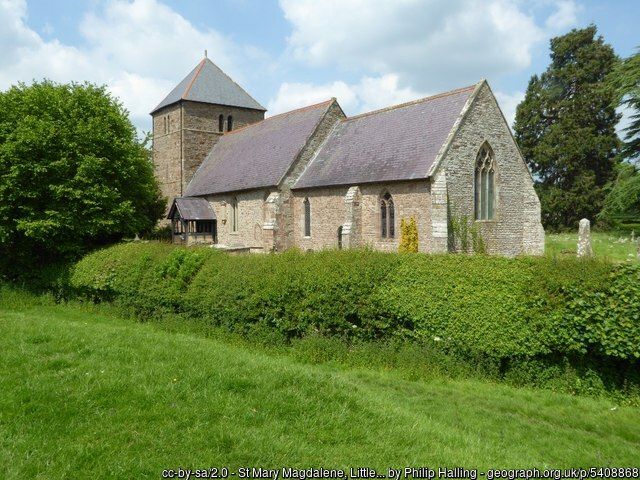
| Description | : | The church of St Mary Magdalene, Little Hereford is situated on the banks of the River Teme and was built in the Norman period, with later additions. It contains a Norman font dating from the late 11th century. In the wall of the nave is the 12th century tomb of Rainauld de la Mere, a blood relation of William the Conqueror, who fought in the Second Crusade. . Between the church and the river, ancient earthworks are the remains of a motte and bailey probably built by King Stephen when he and his army encamped in Little Hereford. They... Read More |
frequently asked questions (FAQ):
-
Where is St. Mary Magdalene Churchyard?
St. Mary Magdalene Churchyard is located at Little Hereford, Herefordshire Unitary Authority ,Herefordshire ,England.
-
St. Mary Magdalene Churchyard cemetery's updated grave count on graveviews.com?
0 memorials
-
Where are the coordinates of the St. Mary Magdalene Churchyard?
Latitude: 52.3112129
Longitude: -2.6572039
Nearby Cemetories:
1. St Mary's Churchyard
Burford, Shropshire Unitary Authority, England
Coordinate: 52.3087670, -2.6126000
2. St Michael's Churchyard Extension
Tenbury Wells, Malvern Hills District, England
Coordinate: 52.2941032, -2.6183906
3. St Michael and All Angels Churchyard
Tenbury Wells, Malvern Hills District, England
Coordinate: 52.2882600, -2.6137900
4. St. Andrew, Ashford Bowdler.
Ashford Bowdler, Shropshire Unitary Authority, England
Coordinate: 52.3308770, -2.7065930
5. St. Mary's Churchyard
Tenbury Wells, Malvern Hills District, England
Coordinate: 52.3120500, -2.5962400
6. St. Mary's Churchyard
Caynham, Shropshire Unitary Authority, England
Coordinate: 52.3558260, -2.6564540
7. Knowbury, St Paul
Caynham, Shropshire Unitary Authority, England
Coordinate: 52.3734750, -2.6300130
8. St. James the Less Churchyard
Kimbolton, Herefordshire Unitary Authority, England
Coordinate: 52.2507757, -2.6957349
9. St. Peter and St. Paul
Leominster, Herefordshire Unitary Authority, England
Coordinate: 52.2704100, -2.7398260
10. St Michael and All Angels Churchyard
Rochford, Malvern Hills District, England
Coordinate: 52.3134240, -2.5454090
11. St Michael & All Angels Churchyard
Knighton-on-Teme, Malvern Hills District, England
Coordinate: 52.3260900, -2.5393500
12. St. Peter's Churchyard
Coreley, Shropshire Unitary Authority, England
Coordinate: 52.3627780, -2.5694950
13. St Marys Churchyard
Kyre, Malvern Hills District, England
Coordinate: 52.2685140, -2.5488360
14. St. Mary's Churchyard
Bitterley, Shropshire Unitary Authority, England
Coordinate: 52.3922280, -2.6319790
15. St. Mary the Virgin Churchyard
Elton, Shropshire Unitary Authority, England
Coordinate: 52.3345972, -2.7969324
16. St. John the Baptist Churchyard
Doddington, Cheshire East Unitary Authority, England
Coordinate: 52.3822068, -2.5651644
17. All Saint's Churchyard
Leominster, Herefordshire Unitary Authority, England
Coordinate: 52.2496430, -2.7703330
18. St Peter & St Paul Churchyard
Eastham, Malvern Hills District, England
Coordinate: 52.3156100, -2.5046000
19. Leominster Nunnery (Defunct)
Leominster, Herefordshire Unitary Authority, England
Coordinate: 52.2294090, -2.7343900
20. Priory Churchyard
Leominster, Herefordshire Unitary Authority, England
Coordinate: 52.2293470, -2.7357830
21. St Michael and All Angels Churchyard
Croft, Herefordshire Unitary Authority, England
Coordinate: 52.2841090, -2.8079510
22. Hopton Bank Methodist Church Burial Ground
Hopton Wafers, Shropshire Unitary Authority, England
Coordinate: 52.3872950, -2.5584430
23. St. Mary the Virgin Churchyard
Bromfield, Shropshire Unitary Authority, England
Coordinate: 52.3873900, -2.7636700
24. St. Peter's Churchyard
Stoke Bliss, Malvern Hills District, England
Coordinate: 52.2627200, -2.5121300