
| Memorials | : | 0 |
| Location | : | Padbury, Aylesbury Vale District, England |
| Coordinate | : | 51.9720660, -0.9512940 |
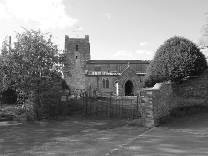
| Description | : | Padbury is a village and also a civil parish within Aylesbury Vale district in Buckinghamshire, England. It is located on the A413 main road that links Buckingham with Winslow. The village had the distinction in Domesday as being one of the few villages in the country still owned by a native rather than a Norman family. It remained in this family (who later took the name 'de Wolverton' after the village of Wolverton) until 1442 when it was sold to All Souls College, Oxford. During the English Civil War Padbury was the site of a skirmish between the Royalist and... Read More |
frequently asked questions (FAQ):
-
Where is St Marys Churchyard?
St Marys Churchyard is located at Church Lane Padbury, Aylesbury Vale District ,Buckinghamshire , MK18 2AJEngland.
-
St Marys Churchyard cemetery's updated grave count on graveviews.com?
0 memorials
-
Where are the coordinates of the St Marys Churchyard?
Latitude: 51.9720660
Longitude: -0.9512940
Nearby Cemetories:
1. St. Cecilia Churchyard
Adstock, Aylesbury Vale District, England
Coordinate: 51.9646400, -0.9314500
2. St. Mary's Churchyard
Addington, Aylesbury Vale District, England
Coordinate: 51.9497100, -0.9206790
3. St. Mary's Churchyard
Thornborough, Aylesbury Vale District, England
Coordinate: 51.9964070, -0.9189690
4. Old St Peter and St Paul Churchyard
Buckingham, Aylesbury Vale District, England
Coordinate: 51.9966610, -0.9908980
5. Saint Peter and Saint Paul Churchyard
Buckingham, Aylesbury Vale District, England
Coordinate: 51.9981040, -0.9893520
6. All Saints Churchyard
Hillesden, Aylesbury Vale District, England
Coordinate: 51.9582028, -1.0045972
7. Friends Meeting House Burial Ground
Buckingham, Aylesbury Vale District, England
Coordinate: 52.0017400, -0.9867000
8. Holy Trinity Churchyard
Gawcott-with-Lenborough, Aylesbury Vale District, England
Coordinate: 51.9809000, -1.0114000
9. Buckingham Cemetery
Buckingham, Aylesbury Vale District, England
Coordinate: 52.0011610, -0.9962420
10. St. Michael Churchyard
Steeple Claydon, Aylesbury Vale District, England
Coordinate: 51.9345150, -0.9752060
11. St. Edmund's Churchyard
Maids Moreton, Aylesbury Vale District, England
Coordinate: 52.0104310, -0.9722660
12. St Leonard's Churchyard
Foscote, Aylesbury Vale District, England
Coordinate: 52.0154000, -0.9571000
13. St. James Churchyard
Great Horwood, Aylesbury Vale District, England
Coordinate: 51.9740230, -0.8792870
14. Middle Claydon Cemetery
Middle Claydon, Aylesbury Vale District, England
Coordinate: 51.9264680, -0.9504380
15. Saint John the Evangelist Churchyard
Buckingham, Aylesbury Vale District, England
Coordinate: 51.9996500, -1.0174090
16. All Saints Churchyard
Middle Claydon, Aylesbury Vale District, England
Coordinate: 51.9214610, -0.9560130
17. St. Mary the Virgin Churchyard
East Claydon, Aylesbury Vale District, England
Coordinate: 51.9234470, -0.9254750
18. St. Michael & All Angels Churchyard
Thornton, Aylesbury Vale District, England
Coordinate: 52.0194400, -0.9055200
19. St. John the Baptist Churchyard
Preston Bissett, Aylesbury Vale District, England
Coordinate: 51.9637380, -1.0440980
20. St. Mary's Churchyard
Tingewick, Aylesbury Vale District, England
Coordinate: 51.9919690, -1.0432400
21. All Saints Churchyard
Nash, Aylesbury Vale District, England
Coordinate: 51.9990300, -0.8634000
22. Church of the Assumption of Blessed Virgin Mary
Stowe, Aylesbury Vale District, England
Coordinate: 52.0182720, -1.0174270
23. St. Nicholas Churchyard
Little Horwood, Aylesbury Vale District, England
Coordinate: 51.9703630, -0.8508680
24. St. James' Churchyard
Akeley, Aylesbury Vale District, England
Coordinate: 52.0340000, -0.9692000