
| Memorials | : | 0 |
| Location | : | Ford, Shropshire Unitary Authority, England |
| Coordinate | : | 52.7184248, -2.8715080 |
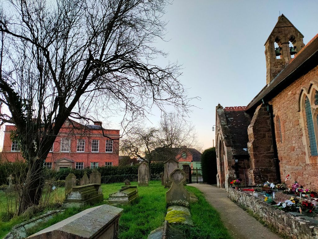
| Description | : | The parish church of St Michael is located on a mound in the village of Ford, six miles west of Shrewsbury in Shropshire. It was built circa 1200 with early 14th century and mid-19th century alterations. It was restored, enlarged and partly rebuilt in 1875 by E. Haycock of Shrewsbury. The churchyard lies mainly south of the church and contains two Commonwealth war graves. |
frequently asked questions (FAQ):
-
Where is St. Michael Churchyard?
St. Michael Churchyard is located at Ford, Shropshire Unitary Authority ,Shropshire ,England.
-
St. Michael Churchyard cemetery's updated grave count on graveviews.com?
0 memorials
-
Where are the coordinates of the St. Michael Churchyard?
Latitude: 52.7184248
Longitude: -2.8715080
Nearby Cemetories:
1. St. Michael’s Churchyard
Cardeston, Shropshire Unitary Authority, England
Coordinate: 52.7050600, -2.8960090
2. Bicton Cemetery
Bicton, Shropshire Unitary Authority, England
Coordinate: 52.7284870, -2.8183830
3. Alberbury Priory
Alberbury, Shropshire Unitary Authority, England
Coordinate: 52.7311000, -2.9267000
4. St Thomas Churchyard
Great Hanwood, Shropshire Unitary Authority, England
Coordinate: 52.6812150, -2.8242660
5. St. Michael and All Angels Churchyard
Alberbury, Shropshire Unitary Authority, England
Coordinate: 52.7236380, -2.9509280
6. St Peter and St Paul Churchyard
Fitz, Shropshire Unitary Authority, England
Coordinate: 52.7553657, -2.8182247
7. All Saints Churchyard
Baschurch, Shropshire Unitary Authority, England
Coordinate: 52.7913710, -2.8586210
8. Bomere Heath Methodist Church Burial Ground
Bomere Heath, Shropshire Unitary Authority, England
Coordinate: 52.7734260, -2.7833720
9. St John the Baptist Churchyard
Albrighton, Shropshire Unitary Authority, England
Coordinate: 52.7572400, -2.7462600
10. Habberley St Mary's Church
Atcham, Shropshire Unitary Authority, England
Coordinate: 52.6266060, -2.8897140
11. St. John’s Churchyard
Condover, Shropshire Unitary Authority, England
Coordinate: 52.6356110, -2.7833220
12. All Saints Churchyard
Alberbury, Shropshire Unitary Authority, England
Coordinate: 52.7062510, -3.0333570
13. St. Edith's Churchyard
Church Pulverbatch, Shropshire Unitary Authority, England
Coordinate: 52.6210550, -2.8436610
14. St. Mary & St. Andrew Churchyard
Condover, Shropshire Unitary Authority, England
Coordinate: 52.6474199, -2.7484076
15. St. Mary Magdalene Church
Hadnall, Shropshire Unitary Authority, England
Coordinate: 52.7759670, -2.7100180
16. Saint Michael and All Angels Churchyard
Felton, Northumberland Unitary Authority, England
Coordinate: 52.8203010, -2.9792430
17. St. Eata's Churchyard
Atcham, Shropshire Unitary Authority, England
Coordinate: 52.6785350, -2.6803958
18. All Saints Churchyard
Berrington, Shropshire Unitary Authority, England
Coordinate: 52.6574020, -2.6957330
19. Holy Trinity Churchyard
Hope, Shropshire Unitary Authority, England
Coordinate: 52.6070670, -2.9747750
20. All Saints Church
Clive, Shropshire Unitary Authority, England
Coordinate: 52.8116250, -2.7212930
21. St. Simon and St. Jude Churchyard
Cockshutt, Shropshire Unitary Authority, England
Coordinate: 52.8577297, -2.8412706
22. St. Mark's Churchyard
Frodesley, Shropshire Unitary Authority, England
Coordinate: 52.6052775, -2.7166580
23. St. Mary's Churchyard
Acton Burnell, Shropshire Unitary Authority, England
Coordinate: 52.6131390, -2.6907390
24. St Peter's Church
Cound, Shropshire Unitary Authority, England
Coordinate: 52.6409160, -2.6542780