
| Memorials | : | 0 |
| Location | : | St Osyth, Tendring District, England |
| Coordinate | : | 51.7991400, 1.0749050 |
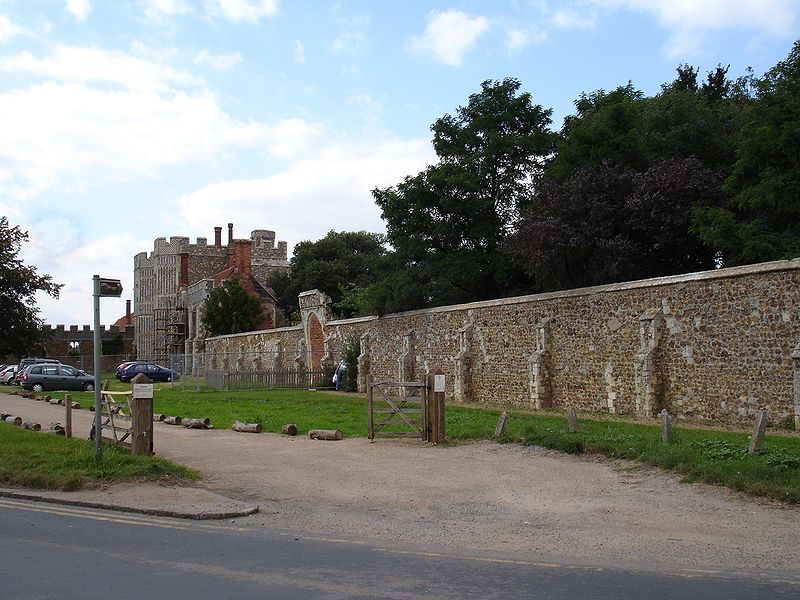
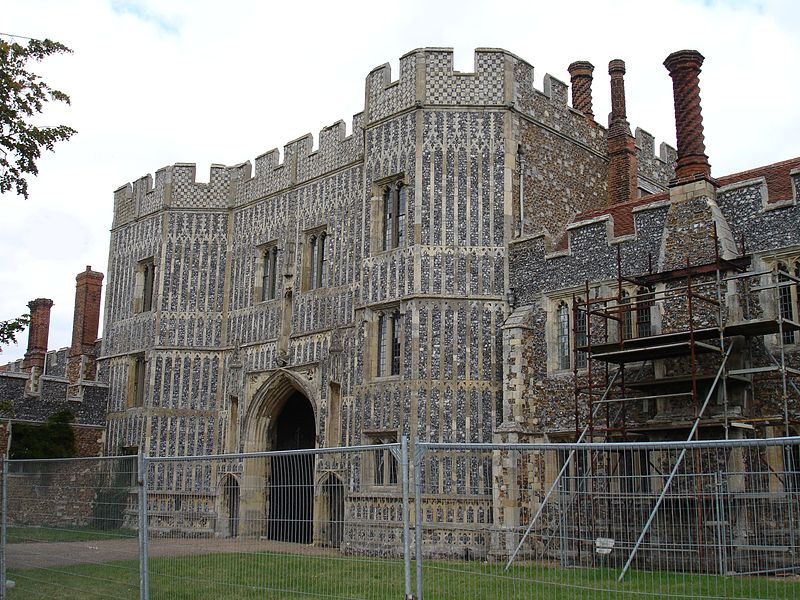
| Description | : | The Priory was founded shortly after 1120 by Richard de Belmeis, Bishop of London, as a house for Augustinian canons from Holy Trinity, London. The Priory was dedicated to Saints Peter and Paul, and St Osyth and became an abbey before 1161.These abbey buildings survive to varying degrees of intactness, the most prominent today being the gatehouse and the Abbot’s Lodging, both reflecting the abbey’s wealth in the late medieval period. |
frequently asked questions (FAQ):
-
Where is St Osyths Priory?
St Osyths Priory is located at St Osyth, Tendring District ,Essex ,England.
-
St Osyths Priory cemetery's updated grave count on graveviews.com?
0 memorials
-
Where are the coordinates of the St Osyths Priory?
Latitude: 51.7991400
Longitude: 1.0749050
Nearby Cemetories:
1. Ss Peter and Paul churchyard
St Osyth, Tendring District, England
Coordinate: 51.7985550, 1.0771640
2. St Osyth Cemetery
St Osyth, Tendring District, England
Coordinate: 51.8051920, 1.0832480
3. St Mary Magdalene Churchyard
Thorrington, Tendring District, England
Coordinate: 51.8357310, 1.0446130
4. All Saints with St. James Churchyard
Brightlingsea, Tendring District, England
Coordinate: 51.8285070, 1.0130530
5. St John the Baptist Churchyard
Clacton-on-Sea, Tendring District, England
Coordinate: 51.8049495, 1.1564588
6. Clacton Cemetery
Clacton-on-Sea, Tendring District, England
Coordinate: 51.8080410, 1.1650260
7. St Andrew Churchyard
Weeley, Tendring District, England
Coordinate: 51.8507210, 1.1264710
8. Weeley Crematorium
Weeley, Tendring District, England
Coordinate: 51.8596020, 1.1097050
9. St Edmund Churchyard
East Mersea, Colchester Borough, England
Coordinate: 51.7886840, 0.9723200
10. Frating Churchyard
Frating, Tendring District, England
Coordinate: 51.8607700, 1.0225800
11. St Michael Churchyard
Thorpe-le-Soken, Tendring District, England
Coordinate: 51.8566770, 1.1631870
12. St. Edmund King and Martyr Churchyard
Tendring, Tendring District, England
Coordinate: 51.8749900, 1.1123400
13. St. Mary's Churchyard
Little Bentley, Tendring District, England
Coordinate: 51.8824400, 1.0823100
14. St. Mary the Virgin Churchyard
Wivenhoe, Colchester Borough, England
Coordinate: 51.8550794, 0.9594897
15. Wivenhoe Cemetery
Wivenhoe, Colchester Borough, England
Coordinate: 51.8616700, 0.9654580
16. St. Andrew's Churchyard
Fingringhoe, Colchester Borough, England
Coordinate: 51.8452150, 0.9451480
17. All Saints Churchyard
Frinton-on-Sea, Tendring District, England
Coordinate: 51.8287263, 1.2192621
18. St. Leonard's Churchyard
Beaumont, Tendring District, England
Coordinate: 51.8778500, 1.1656000
19. St. Lawrence Churchyard
East Donyland, Colchester Borough, England
Coordinate: 51.8556150, 0.9462830
20. Kirby Cross Cemetery
Kirby Cross, Tendring District, England
Coordinate: 51.8401820, 1.2181840
21. Old St. Lawrence Churchyard
East Donyland, Colchester Borough, England
Coordinate: 51.8525110, 0.9383250
22. East Donyland Parish Cemetery
Fingringhoe, Colchester Borough, England
Coordinate: 51.8527840, 0.9378370
23. Barfield Road Burial Ground
West Mersea, Colchester Borough, England
Coordinate: 51.7782400, 0.9144400
24. St Peter & St Paul Churchyard
West Mersea, Colchester Borough, England
Coordinate: 51.7750700, 0.9108780