| Memorials | : | 2 |
| Location | : | Brotton, Redcar and Cleveland Unitary Authority, England |
| Coordinate | : | 54.5679900, -0.9316200 |
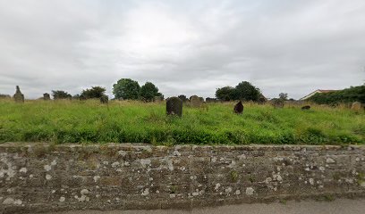
| Description | : | St Peter's Church (demolished in about 1958) was the parish church of Brotton until the church of St Margaret of Antioch was consecrated, along with the grounds, in 1891. St Peter's became the Mortuary Chapel for the village and its burial ground continued in use until the 1950s, when the then local council opened the public cemetery next to St Peter's. |
frequently asked questions (FAQ):
-
Where is St Peter Churchyard?
St Peter Churchyard is located at Kilton Lane Brotton, Redcar and Cleveland Unitary Authority ,North Yorkshire ,England.
-
St Peter Churchyard cemetery's updated grave count on graveviews.com?
2 memorials
-
Where are the coordinates of the St Peter Churchyard?
Latitude: 54.5679900
Longitude: -0.9316200
Nearby Cemetories:
1. Brotton Cemetery
Brotton, Redcar and Cleveland Unitary Authority, England
Coordinate: 54.5670800, -0.9310100
2. St. Margaret of Antioch Church Cemetery
Brotton, Redcar and Cleveland Unitary Authority, England
Coordinate: 54.5662700, -0.9305900
3. St Margaret of Antioch Churchyard
Brotton, Redcar and Cleveland Unitary Authority, England
Coordinate: 54.5691380, -0.9358330
4. St Helen's
Carlin How, Redcar and Cleveland Unitary Authority, England
Coordinate: 54.5673410, -0.9024120
5. Skelton Cemetery
Skelton, Redcar and Cleveland Unitary Authority, England
Coordinate: 54.5604320, -0.9736353
6. St Leonard Churchyard
Loftus, Redcar and Cleveland Unitary Authority, England
Coordinate: 54.5532560, -0.8855250
7. Saltburn by the Sea Cemetery
Saltburn-by-the-Sea, Redcar and Cleveland Unitary Authority, England
Coordinate: 54.5808780, -0.9880640
8. St. Michael Churchyard
Liverton, Redcar and Cleveland Unitary Authority, England
Coordinate: 54.5370370, -0.9025160
9. All Saints Old Churchyard
Skelton, Redcar and Cleveland Unitary Authority, England
Coordinate: 54.5623500, -0.9927600
10. Boosbeck Cemetery
Boosbeck, Redcar and Cleveland Unitary Authority, England
Coordinate: 54.5434900, -0.9779200
11. St Aidan Churchyard
Boosbeck, Redcar and Cleveland Unitary Authority, England
Coordinate: 54.5428560, -0.9786800
12. Loftus Cemetery
Loftus, Redcar and Cleveland Unitary Authority, England
Coordinate: 54.5532380, -0.8716350
13. St Mary Churchyard
Moorsholm, Redcar and Cleveland Unitary Authority, England
Coordinate: 54.5207800, -0.9375800
14. St. Andrew's Old Churchyard
Upleatham, Redcar and Cleveland Unitary Authority, England
Coordinate: 54.5656900, -1.0164700
15. All Saints Churchyard
Easington, Redcar and Cleveland Unitary Authority, England
Coordinate: 54.5520200, -0.8499800
16. St. Germain Churchyard
Marske-by-the-Sea, Redcar and Cleveland Unitary Authority, England
Coordinate: 54.5946000, -1.0115200
17. Guisborough Cemetery
Guisborough, Redcar and Cleveland Unitary Authority, England
Coordinate: 54.5448330, -1.0430940
18. St Nicholas Churchyard
Roxby, Scarborough Borough, England
Coordinate: 54.5365810, -0.8256590
19. St. Nicholas Churchyard
Guisborough, Redcar and Cleveland Unitary Authority, England
Coordinate: 54.5366500, -1.0482800
20. Guisborough Priory
Guisborough, Redcar and Cleveland Unitary Authority, England
Coordinate: 54.5361700, -1.0489500
21. Quakers Burial Ground
Guisborough, Redcar and Cleveland Unitary Authority, England
Coordinate: 54.5355100, -1.0569760
22. Kirkleatham Memorial Park and Crematorium
Yearby, Redcar and Cleveland Unitary Authority, England
Coordinate: 54.5866300, -1.0753800
23. St Peter Churchyard
Commondale, Scarborough Borough, England
Coordinate: 54.4863700, -0.9766200
24. Redcar Cemetery
Redcar, Redcar and Cleveland Unitary Authority, England
Coordinate: 54.6105800, -1.0609200

