
| Memorials | : | 2069 |
| Location | : | Halton, City of Lancaster, England |
| Coordinate | : | 54.0759400, -2.7672600 |
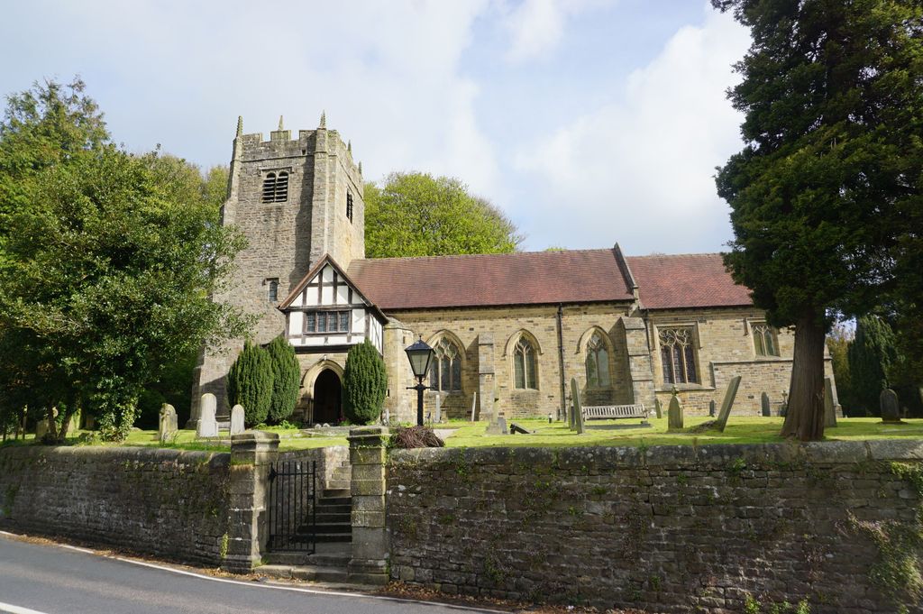
| Description | : | An Anglican church on the West side of the village of Halton-on-Lune, 3 miles NE of the city of Lancaster. It is an active parish church in the Diocese of Blackburn and the archdeaconry of Lancaster. Halton may have been the site of an ancient Anglo-Saxon minster. Of the current structure, the tower dates from the 16th century and the remainder was built 1876–77 by Paley and Austin. The church is recorded in the National Heritage List for England as a designated Grade II listed building. The cemetery surrounds the church. South of the church lies an... Read More |
frequently asked questions (FAQ):
-
Where is St Wilfrid's Churchyard?
St Wilfrid's Churchyard is located at Halton Road, Halton-on-Lune Halton, City of Lancaster ,Lancashire , LA2 6LREngland.
-
St Wilfrid's Churchyard cemetery's updated grave count on graveviews.com?
86 memorials
-
Where are the coordinates of the St Wilfrid's Churchyard?
Latitude: 54.0759400
Longitude: -2.7672600
Nearby Cemetories:
1. Skerton Cemetery
Lancaster, City of Lancaster, England
Coordinate: 54.0651430, -2.7951140
2. Slyne Cemetery
Slyne, City of Lancaster, England
Coordinate: 54.0868185, -2.7969423
3. Lancaster Cemetery
Lancaster, City of Lancaster, England
Coordinate: 54.0504210, -2.7768760
4. Saint Luke's Parish Churchyard
Skerton, City of Lancaster, England
Coordinate: 54.0564700, -2.7982600
5. Christ Church United Reform Church
Bolton-le-Sands, City of Lancaster, England
Coordinate: 54.1015860, -2.7929000
6. Holy Trinity Churchyard
Bolton-le-Sands, City of Lancaster, England
Coordinate: 54.1027700, -2.7911700
7. Nether Kellet Congregational Church
Nether Kellet, City of Lancaster, England
Coordinate: 54.1070772, -2.7587630
8. St. John the Evangelist Churchyard
Lancaster, City of Lancaster, England
Coordinate: 54.0504000, -2.7990000
9. Lancaster and Morecambe Crematorium
Lancaster, City of Lancaster, England
Coordinate: 54.0650890, -2.8198420
10. Cathedral Cemetery of Lancaster
Lancaster, City of Lancaster, England
Coordinate: 54.0471170, -2.7942920
11. St. Nicholas Street Chapel Churchyard
Lancaster, City of Lancaster, England
Coordinate: 54.0486900, -2.7987900
12. Lancaster Priory
Lancaster, City of Lancaster, England
Coordinate: 54.0507360, -2.8057850
13. Lancaster Castle Cemetery
Lancaster, City of Lancaster, England
Coordinate: 54.0494330, -2.8047890
14. Friends Meeting House Burial Ground
Lancaster, City of Lancaster, England
Coordinate: 54.0482500, -2.8058025
15. Mount Street Congregational Chapel
Lancaster, City of Lancaster, England
Coordinate: 54.0468260, -2.8027430
16. St. Paul Churchyard
Caton, City of Lancaster, England
Coordinate: 54.0757840, -2.7009980
17. St Peter's Churchyard
Quernmore, City of Lancaster, England
Coordinate: 54.0367200, -2.7375400
18. Torrisholme Cemetery
Morecambe, City of Lancaster, England
Coordinate: 54.0638980, -2.8409800
19. St Cuthbert Churchyard
Over Kellet, City of Lancaster, England
Coordinate: 54.1195480, -2.7318200
20. Carnforth Cemetery
Carnforth, City of Lancaster, England
Coordinate: 54.1245420, -2.7587820
21. Scotforth Cemetery
Scotforth, City of Lancaster, England
Coordinate: 54.0282250, -2.8007170
22. Holy Trinity Church Poulton-le-Sands
Morecambe, City of Lancaster, England
Coordinate: 54.0744769, -2.8569331
23. Morecambe Cemetery
Morecambe, City of Lancaster, England
Coordinate: 54.0759090, -2.8572610
24. St. Saviour's Church
Halton, City of Lancaster, England
Coordinate: 54.1025610, -2.6891750