
| Memorials | : | 0 |
| Location | : | Uithuizen, Eemsmond Municipality, Netherlands |
| Coordinate | : | 53.4069400, 6.6704800 |
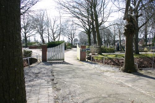
| Description | : | Uithuizen is 30 kilometres north-north-east of Groningen. The cemetery is in the centre of Uithuizen, on the right hand side of Hoofdstraat West - a one way street in the town centre. From Hoofdstraat West turn into a small tree lined lane with the clothes shop Paping on the corner. The cemetery is at the end of this lane. |
frequently asked questions (FAQ):
-
Where is Uithuizen Old General Cemetery?
Uithuizen Old General Cemetery is located at Uithuizen, Eemsmond Municipality ,Groningen ,Netherlands.
-
Uithuizen Old General Cemetery cemetery's updated grave count on graveviews.com?
0 memorials
-
Where are the coordinates of the Uithuizen Old General Cemetery?
Latitude: 53.4069400
Longitude: 6.6704800
Nearby Cemetories:
1. Israëlitische Begraafplaats
Uithuizen, Eemsmond Municipality, Netherlands
Coordinate: 53.4058100, 6.6701800
2. Uithuizen Roman Catholic Cemetery
Uithuizen, Eemsmond Municipality, Netherlands
Coordinate: 53.4068300, 6.6664800
3. Zandeweer Algemene Begraafplaats
Zandeweer, Eemsmond Municipality, Netherlands
Coordinate: 53.3858400, 6.6801400
4. Uithuizermeeden General Cemetery
Uithuizermeeden, Eemsmond Municipality, Netherlands
Coordinate: 53.4080100, 6.7117200
5. Usquert General Cemetery
Usquert, Eemsmond Municipality, Netherlands
Coordinate: 53.4045800, 6.6109600
6. Kantens Algemene begraafplaats
Kantens, Eemsmond Municipality, Netherlands
Coordinate: 53.3662600, 6.6333800
7. Toornwerd Begraafplaats
Toornwerd, Loppersum Municipality, Netherlands
Coordinate: 53.3538400, 6.6360700
8. Saint Hippolytus Churchyard
Middelstum, Loppersum Municipality, Netherlands
Coordinate: 53.3477817, 6.6412390
9. Middelstum Cemetery
Middelstum, Loppersum Municipality, Netherlands
Coordinate: 53.3443200, 6.6451600
10. Warffum Communal Cemetery
Warffum, Eemsmond Municipality, Netherlands
Coordinate: 53.3935400, 6.5585300
11. Oosteinde Cemetery
Oosteinde, Eemsmond Municipality, Netherlands
Coordinate: 53.4147200, 6.7939300
12. Westerwijtwerd Churchyard
Westerwijtwerd, Loppersum Municipality, Netherlands
Coordinate: 53.3339900, 6.6444100
13. 't Zandt Algemene Begraafplaats
't Zandt, Loppersum Municipality, Netherlands
Coordinate: 53.3627600, 6.7759900
14. Stedum Cemetery
Stedum, Loppersum Municipality, Netherlands
Coordinate: 53.3251900, 6.6873400
15. Loppersum General Cemetery
Loppersum, Loppersum Municipality, Netherlands
Coordinate: 53.3307500, 6.7485600
16. Godlinze Cemetery
Godlinze, Delfzijl Municipality, Netherlands
Coordinate: 53.3713200, 6.8187300
17. Den Andel Protestant Cemetery
Den Andel, Winsum Municipality, Netherlands
Coordinate: 53.3855700, 6.5096200
18. Baflo Cemetery
Baflo, Winsum Municipality, Netherlands
Coordinate: 53.3622100, 6.5232900
19. Spijk Cemetery
Spijk, Delfzijl Municipality, Netherlands
Coordinate: 53.3875600, 6.8366400
20. Sint Annen Begraafplaats
Sint Annen, Ten Boer Municipality, Netherlands
Coordinate: 53.2965300, 6.6592300
21. Westernieland General Cemetery
Westernieland, De Marne Municipality, Netherlands
Coordinate: 53.4026700, 6.4779200
22. Bedum Algemene Begraafplaats
Bedum, Bedum Municipality, Netherlands
Coordinate: 53.2969400, 6.6033200
23. Bierum Begraafplaats
Bierum, Delfzijl Municipality, Netherlands
Coordinate: 53.3833351, 6.8666668
24. Bellingeweer Cemetery
Bellingeweer, Winsum Municipality, Netherlands
Coordinate: 53.3253200, 6.5182100