
| Memorials | : | 56 |
| Location | : | Scotland |
| Coordinate | : | 55.0399246, -3.6174200 |
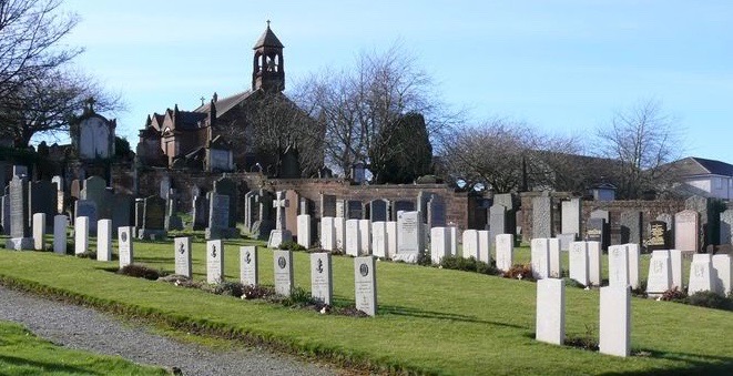
| Description | : | Troqueer is 1 mile south-west of Dumfries railway station. There are 8 Commonwealth burials from World War I and 34 (including 1 unidentified airman of the R.A.F. from World War II in this cemetery. Most burials are in a Service Plot but there are a few in other parts of the cemetery. There are also 17 Foreign National burials and 1 non-World War burial here. Most of the foreign burials are Norwegian. During World War II, Dumfries was host to the the Norwegian Military High Command in exile. Their headquarters was located in a building in the centre of... Read More |
frequently asked questions (FAQ):
-
Where is Troqueer New Burial Ground?
Troqueer New Burial Ground is located at Dumfries and Galloway ,Scotland.
-
Troqueer New Burial Ground cemetery's updated grave count on graveviews.com?
56 memorials
-
Where are the coordinates of the Troqueer New Burial Ground?
Latitude: 55.0399246
Longitude: -3.6174200
Nearby Cemetories:
1. Troqueer Parish Churchyard
Scotland
Coordinate: 55.0398254, -3.6175921
2. Caerlaverock Parish Churchyard
Scotland
Coordinate: 55.0072220, -3.5263890
3. Irongray Churchyard
Scotland
Coordinate: 55.0986790, -3.7017490
4. Irongray Kirkyard - Extention
Scotland
Coordinate: 55.1034857, -3.7632859
5. Southwick Cemetery
Scotland
Coordinate: 54.8953040, -3.7064180
6. Buittle Cemetery
Scotland
Coordinate: 54.9195320, -3.8605370
7. Colvend Parish Churchyard
Scotland
Coordinate: 54.8683920, -3.7742470
8. Keir Churchyard
Scotland
Coordinate: 55.2198710, -3.7941310
9. Balmaghie Parish Churchyard
Scotland
Coordinate: 54.9750000, -3.9969440
10. St Paul's Churchyard
Causewayhead, Allerdale Borough, England
Coordinate: 54.8671390, -3.3552630
11. Silloth Cemetery
Silloth, Allerdale Borough, England
Coordinate: 54.8666200, -3.3551000
12. Quaker Burial Ground
Beckfoot, Copeland Borough, England
Coordinate: 54.8330850, -3.4134130
13. St Michael Churchyard
Bowness-on-Solway, Allerdale Borough, England
Coordinate: 54.9523800, -3.2135380
14. Wesleyan Home Mission Chapel Cemetery
Bowness-on-Solway, Allerdale Borough, England
Coordinate: 54.9535940, -3.2120460
15. St John's Churchyard
Newton Arlosh, Allerdale Borough, England
Coordinate: 54.8853180, -3.2506160
16. Holme St Cuthbert Churchyard
Holme St Cuthbert, Allerdale Borough, England
Coordinate: 54.8108780, -3.3951990
17. Kirkcormack Cemetery
Scotland
Coordinate: 54.8946900, -4.0027600
18. Holme Cultram Abbey Churchyard
Abbeytown, Allerdale Borough, England
Coordinate: 54.8453090, -3.2832650
19. St Bride Churchyard
Kirkbride, Allerdale Borough, England
Coordinate: 54.9047600, -3.2026500
20. Quaker Burial Ground
Allonby, Allerdale Borough, England
Coordinate: 54.7790680, -3.4296924
21. Christ Churchyard
Allonby, Allerdale Borough, England
Coordinate: 54.7671880, -3.4309950
22. St. Mungo Churchyard
Bromfield, Allerdale Borough, England
Coordinate: 54.8109800, -3.2838200
23. St Matthew’s Churchyard
Westnewton, Allerdale Borough, England
Coordinate: 54.7848970, -3.3455930
24. St James Churchyard
Hayton, Allerdale Borough, England
Coordinate: 54.7625930, -3.3880000