
| Memorials | : | 2 |
| Location | : | York, York Unitary Authority, England |
| Coordinate | : | 53.9486800, -1.1008400 |
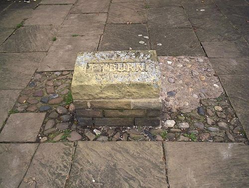
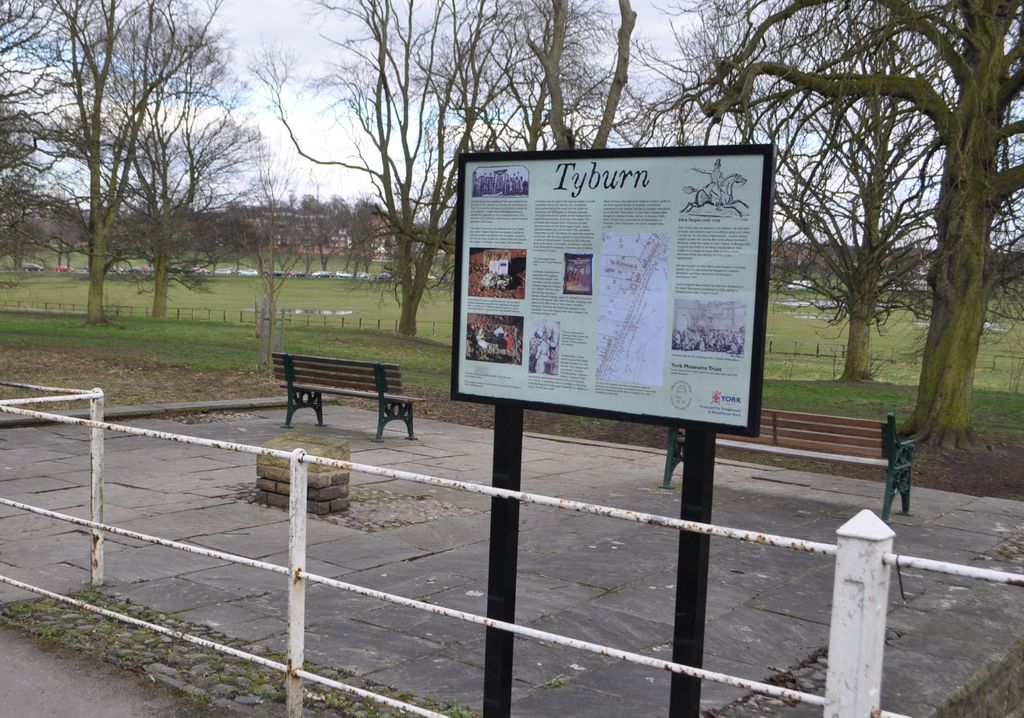
| Description | : | For many years, Knavesmire was the site of public hangings in York. The gallows were erected in 1379, a few miles outside the city on the main southern approach road (now known as the A1036 Tadcaster Road).[3] The execution site was often referred to as "York Tyburn" after the original Tyburn gallows in Middlesex.[4] Probably the most famous people to be executed there were Rhys ap Maredudd, a Welsh nobleman and rebel, hanged in 1292, and Dick Turpin, who was hanged in 1739. By the beginning of the 19th century, it was felt that the gallows did not create a good... Read More |
frequently asked questions (FAQ):
-
Where is Tyburn Cemetery?
Tyburn Cemetery is located at Tadcaster Road York, York Unitary Authority ,North Yorkshire ,England.
-
Tyburn Cemetery cemetery's updated grave count on graveviews.com?
2 memorials
-
Where are the coordinates of the Tyburn Cemetery?
Latitude: 53.9486800
Longitude: -1.1008400
Nearby Cemetories:
1. St Clement Church
York, York Unitary Authority, England
Coordinate: 53.9511660, -1.0871720
2. St Mary's Convent - The Bar Convent
York, York Unitary Authority, England
Coordinate: 53.9552520, -1.0911020
3. St. Edward the Confessor
Dringhouses, York Unitary Authority, England
Coordinate: 53.9399810, -1.1061270
4. Holy Trinity Priory Churchyard
York, York Unitary Authority, England
Coordinate: 53.9565340, -1.0892450
5. St Mary Bishophill Junior Churchyard
York, York Unitary Authority, England
Coordinate: 53.9558890, -1.0869950
6. St Clement Priory Churchyard (Defunct)
York, York Unitary Authority, England
Coordinate: 53.9524710, -1.0827970
7. St Mary Bishophill Senior Churchyard
York, York Unitary Authority, England
Coordinate: 53.9551780, -1.0849680
8. Friends Burial Ground
York, York Unitary Authority, England
Coordinate: 53.9550140, -1.0846700
9. York Cholera Burial Ground
York, York Unitary Authority, England
Coordinate: 53.9586930, -1.0908420
10. St Martin cum Gregory Churchyard
York, York Unitary Authority, England
Coordinate: 53.9572500, -1.0871400
11. St John Churchyard
York, York Unitary Authority, England
Coordinate: 53.9574440, -1.0854510
12. All Saints North Street Churchyard
York, York Unitary Authority, England
Coordinate: 53.9584400, -1.0862400
13. Blackfriars Abbey Church (Defunct)
York, York Unitary Authority, England
Coordinate: 53.9594100, -1.0880900
14. Greyfriars Abbey Church (Defunct)
York, York Unitary Authority, England
Coordinate: 53.9553090, -1.0814240
15. St Michael Churchyard
York, York Unitary Authority, England
Coordinate: 53.9577900, -1.0825600
16. Carmelite Friary of York (Defunct)
York, York Unitary Authority, England
Coordinate: 53.9577020, -1.0822860
17. Saint Peter's
York, York Unitary Authority, England
Coordinate: 53.9577400, -1.0822600
18. Augustinian Friary, York (Nonextant)
York, York Unitary Authority, England
Coordinate: 53.9601683, -1.0860521
19. St Martin le Grand Churchyard
York, York Unitary Authority, England
Coordinate: 53.9593870, -1.0843800
20. St. Mary Castlegate Churchyard
York, York Unitary Authority, England
Coordinate: 53.9570800, -1.0804370
21. Lendal Congregational Chapel
York, York Unitary Authority, England
Coordinate: 53.9606360, -1.0860970
22. St Peter the Little (Defunct)
York, York Unitary Authority, England
Coordinate: 53.9585310, -1.0821170
23. York Castle Prison Cemetery
York, York Unitary Authority, England
Coordinate: 53.9551950, -1.0782660
24. All Saints Pavement Churchyard
York, York Unitary Authority, England
Coordinate: 53.9581090, -1.0808820