
| Memorials | : | 66 |
| Location | : | Owl Trap, Gloucester County, USA |
| Coordinate | : | 37.5239449, -76.6276016 |
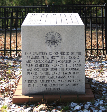
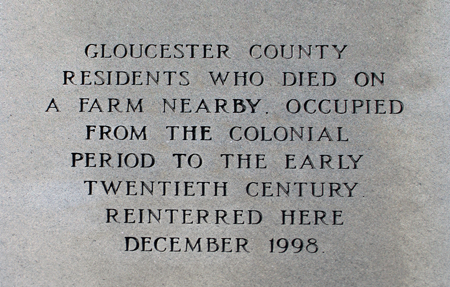
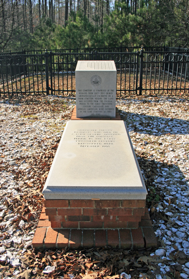
| Description | : | Created in 1998, this cemetery holds the remains of sixty-five graves archaeologically excavated from a nearby farm cemetery. Interments date from the colonial period to the early twentieth century. A granite marker erected at the site details each subject, listing sex, race, and approximate age at time of death. |
frequently asked questions (FAQ):
-
Where is Unnamed Colonial Era Farm Cemetery?
Unnamed Colonial Era Farm Cemetery is located at Owl Trap, Gloucester County ,Virginia ,USA.
-
Unnamed Colonial Era Farm Cemetery cemetery's updated grave count on graveviews.com?
0 memorials
-
Where are the coordinates of the Unnamed Colonial Era Farm Cemetery?
Latitude: 37.5239449
Longitude: -76.6276016
Nearby Cemetories:
1. Salem United Methodist Church Cemetery
Gloucester, Gloucester County, USA
Coordinate: 37.5283210, -76.5938500
2. New Mount Zion Baptist Church Cemetery
Gloucester County, USA
Coordinate: 37.5112070, -76.5924850
3. Saint Andrew Cemetery
Gloucester County, USA
Coordinate: 37.5556960, -76.6166210
4. New Hope United Methodist Church Cemetery
Gloucester County, USA
Coordinate: 37.5592800, -76.6606130
5. Shackelfords Chapel Cemetery
Plain View, King and Queen County, USA
Coordinate: 37.4984000, -76.6741000
6. Beulah Wesleyan Church Cemetery
Cologne, King and Queen County, USA
Coordinate: 37.5471970, -76.6840390
7. Church of God Cemetery
Gloucester, Gloucester County, USA
Coordinate: 37.4736830, -76.6359110
8. Union Prospect Baptist Church Cemetery
Cologne, King and Queen County, USA
Coordinate: 37.5139950, -76.6929080
9. Old Poroporone Cemetery
Cologne, King and Queen County, USA
Coordinate: 37.5228752, -76.6955547
10. Petsworth Parish Episcopal Church Cemetery
Gloucester County, USA
Coordinate: 37.4637186, -76.6046384
11. Morning Glory Baptist Church Cemetery
Gloucester, Gloucester County, USA
Coordinate: 37.4600580, -76.6358830
12. New Hope Memorial Baptist Church Cemetery
Shacklefords, King and Queen County, USA
Coordinate: 37.5790900, -76.6766100
13. Marlfield Plantation Cemetery
Marlfield, Gloucester County, USA
Coordinate: 37.4492760, -76.6223860
14. Ebenezer Baptist Church Cemetery
Gloucester, Gloucester County, USA
Coordinate: 37.4989000, -76.5308960
15. Centenary Cemetery
Middlesex County, USA
Coordinate: 37.6058006, -76.5939026
16. Shepherdsville Baptist Church Cemetery
Gloucester County, USA
Coordinate: 37.4509200, -76.5684680
17. Olive Branch United Methodist Church Cemetery
Harcum, Gloucester County, USA
Coordinate: 37.5070790, -76.5191580
18. Antioch Baptist Church Cemetery
Saluda, Middlesex County, USA
Coordinate: 37.6081009, -76.5942001
19. Poroporone Baptist Church Cemetery
Shacklefords, King and Queen County, USA
Coordinate: 37.5514890, -76.7337300
20. First Baptist Church Cemetery
Shacklefords, King and Queen County, USA
Coordinate: 37.5072460, -76.7377920
21. Zion Hill Baptist Church Cemetery
Gloucester, Gloucester County, USA
Coordinate: 37.4840290, -76.5263470
22. Grace Bible Church Cemetery
Ark, Gloucester County, USA
Coordinate: 37.4411260, -76.5790070
23. Zion Branch Baptist Church Cemetery
Saluda, Middlesex County, USA
Coordinate: 37.6216100, -76.6180000
24. Immanuel Baptist Church Cemetery
Saluda, Middlesex County, USA
Coordinate: 37.6227670, -76.6075410