
| Memorials | : | 0 |
| Location | : | Gloucester County, USA |
| Coordinate | : | 37.4637186, -76.6046384 |
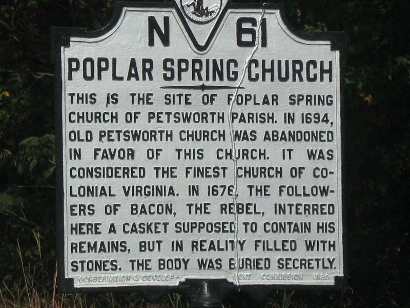
| Description | : | Gloucester County had four original parishes: Abingdon, Ware, Petsworth, and Kingston (Kingston is now part of Mathews county). The Petsworth Parish records are missing portions, so the exact date the original church was built is uncertain, but was there in 1676 the followers of Nathaniel Bacon interred a casket supposedly containing his remains, but in reality filled with stones. It is known that a second Petsworth Parish church was ordered built in 1677 here at Poplar Spring and that the original "Old Church" was in ruins by 1695 and ordered abandoned. In 1723 a new church was built at Poplar Spring, which... Read More |
frequently asked questions (FAQ):
-
Where is Petsworth Parish Episcopal Church Cemetery?
Petsworth Parish Episcopal Church Cemetery is located at Gloucester County ,Virginia ,USA.
-
Petsworth Parish Episcopal Church Cemetery cemetery's updated grave count on graveviews.com?
0 memorials
-
Where are the coordinates of the Petsworth Parish Episcopal Church Cemetery?
Latitude: 37.4637186
Longitude: -76.6046384
Nearby Cemetories:
1. Marlfield Plantation Cemetery
Marlfield, Gloucester County, USA
Coordinate: 37.4492760, -76.6223860
2. Morning Glory Baptist Church Cemetery
Gloucester, Gloucester County, USA
Coordinate: 37.4600580, -76.6358830
3. Church of God Cemetery
Gloucester, Gloucester County, USA
Coordinate: 37.4736830, -76.6359110
4. Grace Bible Church Cemetery
Ark, Gloucester County, USA
Coordinate: 37.4411260, -76.5790070
5. Shepherdsville Baptist Church Cemetery
Gloucester County, USA
Coordinate: 37.4509200, -76.5684680
6. Petsworth Baptist Church Cemetery
Pinetta, Gloucester County, USA
Coordinate: 37.4182300, -76.6205210
7. New Mount Zion Baptist Church Cemetery
Gloucester County, USA
Coordinate: 37.5112070, -76.5924850
8. Bethel Baptist Church Cemetery
Sassafras, Gloucester County, USA
Coordinate: 37.4109200, -76.6086960
9. Unnamed Colonial Era Farm Cemetery
Owl Trap, Gloucester County, USA
Coordinate: 37.5239449, -76.6276016
10. Bellamy Memorial Cemetery
Bellamy, Gloucester County, USA
Coordinate: 37.4014940, -76.5888260
11. Shackelfords Chapel Cemetery
Plain View, King and Queen County, USA
Coordinate: 37.4984000, -76.6741000
12. Salem United Methodist Church Cemetery
Gloucester, Gloucester County, USA
Coordinate: 37.5283210, -76.5938500
13. Zion Hill Baptist Church Cemetery
Gloucester, Gloucester County, USA
Coordinate: 37.4840290, -76.5263470
14. Newington Baptist Church Cemetery
Gloucester, Gloucester County, USA
Coordinate: 37.4174900, -76.5422420
15. Ebenezer Baptist Church Cemetery
Gloucester, Gloucester County, USA
Coordinate: 37.4989000, -76.5308960
16. First Presbyterian Church Columbarium
Gloucester, Gloucester County, USA
Coordinate: 37.4150300, -76.5310400
17. Olive Branch United Methodist Church Cemetery
Harcum, Gloucester County, USA
Coordinate: 37.5070790, -76.5191580
18. Union Prospect Baptist Church Cemetery
Cologne, King and Queen County, USA
Coordinate: 37.5139950, -76.6929080
19. Ware Episcopal Church Cemetery
Gloucester, Gloucester County, USA
Coordinate: 37.4227470, -76.5078880
20. Saint Andrew Cemetery
Gloucester County, USA
Coordinate: 37.5556960, -76.6166210
21. Old Poroporone Cemetery
Cologne, King and Queen County, USA
Coordinate: 37.5228752, -76.6955547
22. Smithfield Baptist Church Cemetery
Gloucester, Gloucester County, USA
Coordinate: 37.3703300, -76.5748250
23. Shiloh Cemetery
Gloucester, Gloucester County, USA
Coordinate: 37.3996010, -76.5123030
24. Gleaning Baptist Church Cemetery
Harcum, Gloucester County, USA
Coordinate: 37.5151120, -76.4972470