
| Memorials | : | 17 |
| Location | : | Wamsley, Adams County, USA |
| Coordinate | : | 38.8369600, -83.2802600 |
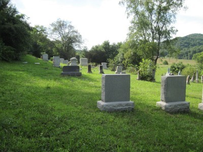
| Description | : | The cemetery is located on the south side of Ohio State Route 348 about 0.1 miles east of its intersection with Ohio State Route 781. The cemetery is located in Jefferson Township, Adams County, Ohio, and is # 42 (Wamsley Cemetery / Wamsleyville Cemetery) in “Ohio Cemeteries 1803-2003”, compiled by the Ohio Genealogical Society. The cemetery is registered with the Ohio Division of Real Estate and Professional Licensing (ODRE) as Wamsley Cemetery Organization with registration license number CGR.0000981592. The U.S. Geological Survey (USGS) Geographic Names Information System (GNIS) feature ID for the cemetery is 1731218 (Wamsley Cemetery /... Read More |
frequently asked questions (FAQ):
-
Where is Wamsleyville Methodist Episcopal Church Cemetery?
Wamsleyville Methodist Episcopal Church Cemetery is located at Ohio State Route 348 Wamsley, Adams County ,Ohio , 45657USA.
-
Wamsleyville Methodist Episcopal Church Cemetery cemetery's updated grave count on graveviews.com?
17 memorials
-
Where are the coordinates of the Wamsleyville Methodist Episcopal Church Cemetery?
Latitude: 38.8369600
Longitude: -83.2802600
Nearby Cemetories:
1. Beech Fork Cemetery
Brush Creek Township, Scioto County, USA
Coordinate: 38.8567009, -83.2457962
2. Antioch Cemetery
Mineral Springs, Adams County, USA
Coordinate: 38.8589000, -83.3180600
3. Koenig Cemetery
Otway, Scioto County, USA
Coordinate: 38.8203000, -83.2272000
4. Mount Unger Cemetery
Blue Creek, Adams County, USA
Coordinate: 38.7856200, -83.2848000
5. Setty-Ode Cemetery
Blue Creek, Adams County, USA
Coordinate: 38.7857700, -83.2871100
6. Oppy Cemetery
Brush Creek Township, Scioto County, USA
Coordinate: 38.7989006, -83.2266998
7. Oswego Cemetery
Brush Creek Township, Scioto County, USA
Coordinate: 38.8178460, -83.2105320
8. New Hoffer Hill Church Cemetery
Rarden, Scioto County, USA
Coordinate: 38.8864920, -83.2419590
9. Moores Chapel Cemetery
Jefferson, Adams County, USA
Coordinate: 38.7850000, -83.3140000
10. White Oak Cemetery
Blue Creek, Adams County, USA
Coordinate: 38.8330000, -83.3550000
11. Aikens Cemetery
Meigs Township, Adams County, USA
Coordinate: 38.8899994, -83.3142014
12. Smith Cemetery
Otway, Scioto County, USA
Coordinate: 38.8525009, -83.2027969
13. Old Hoffer Hill Cemetery
Rarden Township, Scioto County, USA
Coordinate: 38.8903500, -83.2363700
14. Cassel Cemetery
Jefferson Township, Adams County, USA
Coordinate: 38.7980995, -83.3522034
15. Berea Chapel Cemetery
Brush Creek Township, Scioto County, USA
Coordinate: 38.7689000, -83.2613300
16. Parker Cemetery
Otway, Scioto County, USA
Coordinate: 38.7949982, -83.1999969
17. Wintersteen Cemetery
Blue Creek, Adams County, USA
Coordinate: 38.7612100, -83.2827500
18. Moon Cemetery
Brush Creek Township, Scioto County, USA
Coordinate: 38.7943993, -83.1992035
19. Otway Cemetery
Otway, Scioto County, USA
Coordinate: 38.8686800, -83.1912900
20. Peach Mountain Cemetery
Peebles, Adams County, USA
Coordinate: 38.8953018, -83.3450012
21. Garvin Cemetery
Otway, Scioto County, USA
Coordinate: 38.8505770, -83.1825970
22. Blue Creek Hill Cemetery
Blue Creek, Adams County, USA
Coordinate: 38.7623180, -83.3061050
23. Drake Cemetery
Blue Creek, Adams County, USA
Coordinate: 38.7677994, -83.3257980
24. Hazelbaker Cemetery
Blue Creek, Adams County, USA
Coordinate: 38.7734517, -83.3388611