
| Memorials | : | 0 |
| Location | : | Moapa, Clark County, USA |
| Coordinate | : | 36.6645584, -114.6408768 |
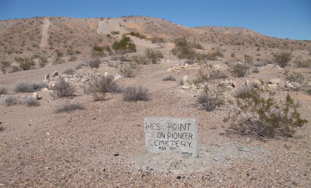
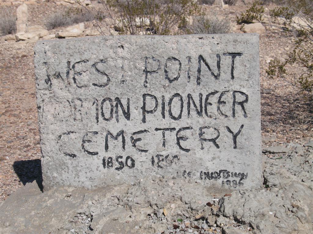
| Description | : | In 1865 Brigham Young dispatched 75 families to the St Thomas area to grow cotton (now under Lake Mead). In the spring of 1868, a small group from St Thomas, led by Andrew Gibbons established West Point, as it was the farthest West of all towns along the Muddy River. Due to harsh conditions it was abandoned in 1871. In 1873, West Point became part of the Moapa River Indian Reservation. From Moa-Pah meaning "bitter or muddy waters. In 1986, Lee Huntsman erected a marker similar to one he placed at the St Joseph Cemetery. The original headstone of... Read More |
frequently asked questions (FAQ):
-
Where is Westpoint Cemetery?
Westpoint Cemetery is located at Moapa, Clark County ,Nevada ,USA.
-
Westpoint Cemetery cemetery's updated grave count on graveviews.com?
0 memorials
-
Where are the coordinates of the Westpoint Cemetery?
Latitude: 36.6645584
Longitude: -114.6408768
Nearby Cemetories:
1. Moapa Paiute Indian Cemetery
Moapa, Clark County, USA
Coordinate: 36.6613007, -114.6594009
2. Warm Springs Cemetery
Moapa, Clark County, USA
Coordinate: 36.7079010, -114.6985016
3. Warm Spring Ranch Burial Site
Moapa, Clark County, USA
Coordinate: 36.7114840, -114.7135450
4. Logandale Cemetery
Logandale, Clark County, USA
Coordinate: 36.5998993, -114.4748001
5. Saint Joseph Cemetery
Logandale, Clark County, USA
Coordinate: 36.5863991, -114.4623032
6. Pioneer Hill Cemetery
Overton, Clark County, USA
Coordinate: 36.5607986, -114.4399033
7. Saint Thomas Cemetery
Overton, Clark County, USA
Coordinate: 36.5205994, -114.4359970
8. Clark Memorial
Overton, Clark County, USA
Coordinate: 36.4253880, -114.4690970
9. Davidson Family Gravesite
Lincoln County, USA
Coordinate: 36.8870811, -114.2647934
10. Bunkerville Cemetery
Bunkerville, Clark County, USA
Coordinate: 36.7742996, -114.1182022
11. New Mesquite City Cemetery
Mesquite, Clark County, USA
Coordinate: 36.8192700, -114.1186000
12. Mesquite City Cemetery
Mesquite, Clark County, USA
Coordinate: 36.8117104, -114.0617905
13. Nay Ranch Cemetery
Riverside, Clark County, USA
Coordinate: 36.5230100, -114.0573700
14. Gold Butte Cemetery
Clark County, USA
Coordinate: 36.2802505, -114.1996994
15. Nellis AFB Freedom Park
Las Vegas, Clark County, USA
Coordinate: 36.2357830, -115.0573550
16. Palm Memorial Park Northwest
Las Vegas, Clark County, USA
Coordinate: 36.2813700, -115.2251700
17. Kiel Ranch Cemetery
North Las Vegas, Clark County, USA
Coordinate: 36.2042000, -115.1408700
18. Littlefield Cemetery
Littlefield, Mohave County, USA
Coordinate: 36.8902016, -113.9279480
19. Woodlawn Cemetery
Las Vegas, Clark County, USA
Coordinate: 36.1871986, -115.1316986
20. Beaver Dam Cemetery
Mohave County, USA
Coordinate: 36.9020157, -113.9256287
21. Bunkers Eden Vale Memorial Park
Las Vegas, Clark County, USA
Coordinate: 36.1841011, -115.1333008
22. Palm Downtown Cemetery
Las Vegas, Clark County, USA
Coordinate: 36.1847992, -115.1377029
23. Las Vegas Paiute Tribe Cemetery
Las Vegas, Clark County, USA
Coordinate: 36.1860008, -115.1399994
24. Hoyt Gravesite
Alamo, Lincoln County, USA
Coordinate: 37.2054400, -115.0550500