
| Memorials | : | 0 |
| Location | : | Clay County, USA |
| Coordinate | : | 39.4481823, -94.3315423 |
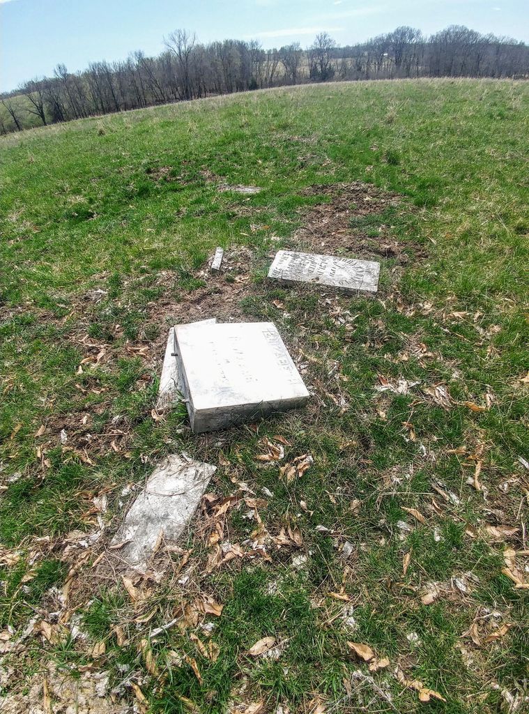
| Description | : | A family cemetery located on Joe Robbinett's farm, west of I-35 on a dead end road south of PP. Township 54, North Range 31, West Section #36 (close to center of Section) One grave has a missing stone, believed to be of a girl named Lamb, 15 years old. Inscription on stone says "Killed by Indians". |
frequently asked questions (FAQ):
-
Where is Wilerton - McClelland Cemetery?
Wilerton - McClelland Cemetery is located at Clay County ,Missouri ,USA.
-
Wilerton - McClelland Cemetery cemetery's updated grave count on graveviews.com?
0 memorials
-
Where are the coordinates of the Wilerton - McClelland Cemetery?
Latitude: 39.4481823
Longitude: -94.3315423
Nearby Cemetories:
1. Antioch Cemetery
Holt, Clay County, USA
Coordinate: 39.4552994, -94.3214035
2. Arnold-Spellman Graveyard
Holt, Clay County, USA
Coordinate: 39.4364000, -94.3320000
3. New Hope Cemetery
Holt, Clay County, USA
Coordinate: 39.4332809, -94.3245773
4. Oakland Cemetery
Haynesville, Clinton County, USA
Coordinate: 39.4631004, -94.3114014
5. Gill Family Cemetery
Holt, Clay County, USA
Coordinate: 39.4496384, -94.2937927
6. Arnold-Holt Cemetery
Clay County, USA
Coordinate: 39.4410000, -94.3682000
7. Muddy Fork Cemetery
Kearney, Clay County, USA
Coordinate: 39.4193993, -94.3703003
8. Wilson Cemetery
Clay County, USA
Coordinate: 39.4192009, -94.2855988
9. Jesse James Farm
Kearney, Clay County, USA
Coordinate: 39.3908360, -94.3224120
10. Estes Family Graveyard
Kearney, Clay County, USA
Coordinate: 39.3973450, -94.3710150
11. Converse Cemetery
Lathrop, Clinton County, USA
Coordinate: 39.4994011, -94.2794037
12. Watkins Mill Cemetery
Clay County, USA
Coordinate: 39.4106800, -94.2603200
13. Fairview Cemetery
Kearney, Clay County, USA
Coordinate: 39.3774986, -94.3597031
14. Mackintyre's Church and Cemetery
Lathrop, Clinton County, USA
Coordinate: 39.5073700, -94.3891100
15. Mount Zion Cemetery
Plattsburg, Clinton County, USA
Coordinate: 39.4672012, -94.4242020
16. Majors Family Cemetery
Excelsior Springs, Clay County, USA
Coordinate: 39.4042358, -94.2513657
17. Estes Cemetery
Clay County, USA
Coordinate: 39.3722038, -94.3583755
18. Bethel Cemetery
Kearney, Clay County, USA
Coordinate: 39.3744011, -94.2902985
19. Crowley Cemetery
Kearney, Clay County, USA
Coordinate: 39.3685989, -94.3086014
20. Eberts Cemetery
Clinton County, USA
Coordinate: 39.4692001, -94.4356003
21. Mount Olivet Cemetery
Kearney, Clay County, USA
Coordinate: 39.3671989, -94.3632965
22. Hollingsworth Family Cemetery
Excelsior Springs, Clay County, USA
Coordinate: 39.4293940, -94.2230050
23. Mount Gilead Cemetery
Kearney, Clay County, USA
Coordinate: 39.3826942, -94.4129410
24. Shady Grove Cemetery
Kearney, Clay County, USA
Coordinate: 39.3605995, -94.3003006