
| Memorials | : | 0 |
| Location | : | Cherry Grove, Caswell County, USA |
| Coordinate | : | 36.2979370, -79.4437910 |
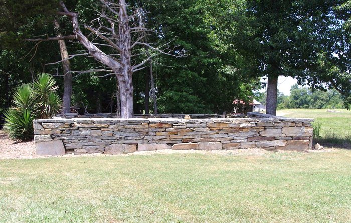
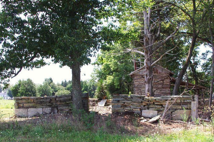
| Description | : | Family Cemetery on Private Property No Recorded Right of Public Access Property Owner's Permission Required Williamson Family Cemetery at Poplar Grove This cemetery is the family of Thomas Williamson and Frances Pannell Banks Farish. Enclosed in a stone wall, the entry was once iron gated. The cemetery appears to contain fourteen to twenty-one graves. Four graves are marked with inscribed stones. The other burials are unknown. The Williamson farm was known as Poplar Grove Plantation. In the vicinity of 752 Stadler Road. Carolina Caswell located this cemetery by Caswell County NC MB 16/504 and MB 16/733. Carolina Caswell conducted a photographic... Read More |
frequently asked questions (FAQ):
-
Where is Williamson Cemetery?
Williamson Cemetery is located at Stadler Road Cherry Grove, Caswell County ,North Carolina ,USA.
-
Williamson Cemetery cemetery's updated grave count on graveviews.com?
0 memorials
-
Where are the coordinates of the Williamson Cemetery?
Latitude: 36.2979370
Longitude: -79.4437910
Nearby Cemetories:
1. Heydon Family Cemetery
Cherry Grove, Caswell County, USA
Coordinate: 36.3055890, -79.4444190
2. Concord Christian Church Cemetery
Cherry Grove, Caswell County, USA
Coordinate: 36.3150000, -79.4390000
3. Massey-Garrison Family Cemetery
Milesville, Caswell County, USA
Coordinate: 36.3014820, -79.4211640
4. Spirit and Truth Baptist Church Cemetery
Milesville, Caswell County, USA
Coordinate: 36.2963860, -79.4131980
5. Ruffin and Miles Family Cemetery
Milesville, Caswell County, USA
Coordinate: 36.3076108, -79.4149997
6. Jones Crossroads Baptist Church Cemetery
Cherry Grove, Caswell County, USA
Coordinate: 36.3204330, -79.4224410
7. Turner Family Cemetery
Locust Hill, Caswell County, USA
Coordinate: 36.3297900, -79.4503520
8. Pinnix Family Cemetery
Milesville, Caswell County, USA
Coordinate: 36.2857960, -79.4039120
9. Family Cemetery on Pagetown Road
Stony Creek, Caswell County, USA
Coordinate: 36.2670100, -79.4629700
10. Stoney Creek AME Church Cemetery
Stony Creek, Caswell County, USA
Coordinate: 36.2624850, -79.4199410
11. Simpson Family Cemetery
Camp Springs, Caswell County, USA
Coordinate: 36.2867690, -79.4928750
12. Leath-Kernodle-Hornbuckle Family Cemetery
Stony Creek, Caswell County, USA
Coordinate: 36.2565420, -79.4391190
13. Scott Family Cemetery
Stony Creek, Caswell County, USA
Coordinate: 36.2562560, -79.4391610
14. Camp Springs United Methodist Church Cemetery
Camp Springs, Caswell County, USA
Coordinate: 36.2952766, -79.4972229
15. Brown Family Cemetery
Camp Springs, Caswell County, USA
Coordinate: 36.3175200, -79.4922640
16. Harris-Swift Cemetery
Stony Creek, Caswell County, USA
Coordinate: 36.2687480, -79.4844800
17. Brown Cemetery
Stony Creek, Caswell County, USA
Coordinate: 36.2582030, -79.4203380
18. Family Cemetery on Apple Road
Camp Springs, Caswell County, USA
Coordinate: 36.2989100, -79.5002500
19. Camp Springs UMC Cemetery
Camp Springs, Caswell County, USA
Coordinate: 36.2930250, -79.5012760
20. Kerrs Chapel Baptist Church Cemetery
Stony Creek, Caswell County, USA
Coordinate: 36.2598640, -79.4098020
21. Norman Family Cemetery
Camp Springs, Caswell County, USA
Coordinate: 36.3129850, -79.5007770
22. Simpson Cemetery
Stony Creek, Caswell County, USA
Coordinate: 36.2496460, -79.4592300
23. Simmons Family Cemetery
Jericho, Caswell County, USA
Coordinate: 36.3195510, -79.3879150
24. Paschal-Butler Family Cemetery
Locust Hill, Caswell County, USA
Coordinate: 36.3403470, -79.4815830