
| Memorials | : | 0 |
| Location | : | Workum, Sudwest Fryslan Municipality, Netherlands |
| Coordinate | : | 52.9789700, 5.4432000 |
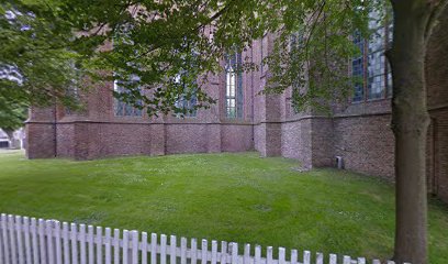
| Description | : | This is the older cemetery in Workum, behind the Saint Gertrudis church. Inside the church the so callled 'draagbaren' are shown. These where used in the past to carry the coffin of the deceased. Several groups used their dedicated coffin carrier. |
frequently asked questions (FAQ):
-
Where is Workum Kerk?
Workum Kerk is located at Merk 5, Workum Workum, Sudwest Fryslan Municipality ,Friesland , 8711CLNetherlands.
-
Workum Kerk cemetery's updated grave count on graveviews.com?
0 memorials
-
Where are the coordinates of the Workum Kerk?
Latitude: 52.9789700
Longitude: 5.4432000
Nearby Cemetories:
1. Workum Spoordyk General Cemetery
Workum, Sudwest Fryslan Municipality, Netherlands
Coordinate: 52.9749667, 5.4484889
2. Joodse Begraafplaats
Workum, Sudwest Fryslan Municipality, Netherlands
Coordinate: 52.9720900, 5.4353100
3. Hieslum Protestant Churchyard
Hieslum, Sudwest Fryslan Municipality, Netherlands
Coordinate: 53.0085400, 5.4884800
4. Hindeloopen Protestant Churchyard
Hindeloopen, Sudwest Fryslan Municipality, Netherlands
Coordinate: 52.9429100, 5.3984900
5. Idsegahuizum Kerkhof
Idsegahuizum, Sudwest Fryslan Municipality, Netherlands
Coordinate: 53.0433420, 5.4180270
6. Koudum General Cemetery
Koudum, Sudwest Fryslan Municipality, Netherlands
Coordinate: 52.9114400, 5.4456200
7. Idzega Klokkenstoel
Idzega, Sudwest Fryslan Municipality, Netherlands
Coordinate: 52.9775587, 5.5581642
8. Rooms-Katholiek Kerkhof St. Vituskerk
Blauwhuis, Sudwest Fryslan Municipality, Netherlands
Coordinate: 53.0228265, 5.5340636
9. Molkwerum Protestant Churchyard
Molkwerum, Sudwest Fryslan Municipality, Netherlands
Coordinate: 52.9001600, 5.3992000
10. Makkum Protestant Churchyard
Makkum, Sudwest Fryslan Municipality, Netherlands
Coordinate: 53.0595500, 5.3997500
11. Doniakerk Kerkhof
Makkum, Sudwest Fryslan Municipality, Netherlands
Coordinate: 53.0597550, 5.3992650
12. Algemene Begraafplaats
Bolsward, Sudwest Fryslan Municipality, Netherlands
Coordinate: 53.0677100, 5.5214800
13. Ijpecolsga General Cemetery
IJpecolsga, Sudwest Fryslan Municipality, Netherlands
Coordinate: 52.9344500, 5.6072800
14. Staveren General Cemetery
Stavoren, Sudwest Fryslan Municipality, Netherlands
Coordinate: 52.8820900, 5.3600500
15. Bakhuizen Roman Catholic Cemetery
Bakhuizen, De Fryske Marren Municipality, Netherlands
Coordinate: 52.8692200, 5.4557500
16. Scharl General Cemetery
Skarl, Sudwest Fryslan Municipality, Netherlands
Coordinate: 52.8672300, 5.3909200
17. Witmarsum Protestant Churchyard
Witmarsum, Sudwest Fryslan Municipality, Netherlands
Coordinate: 53.1021800, 5.4661900
18. Natuurbegraafplaats Bremer Wildernis
Sondel, De Fryske Marren Municipality, Netherlands
Coordinate: 52.8714341, 5.5754786
19. Tirns Kerkhof
Tirns, Sudwest Fryslan Municipality, Netherlands
Coordinate: 53.0589810, 5.6260940
20. Kerkhof Oudemirdum
Oudemirdum, De Fryske Marren Municipality, Netherlands
Coordinate: 52.8498364, 5.5332713
21. Kerkhof NH Vaste Burchtker
Wijckel, De Fryske Marren Municipality, Netherlands
Coordinate: 52.8889630, 5.6246630
22. Nijemirdum General Cemetery
Nijemirdum, De Fryske Marren Municipality, Netherlands
Coordinate: 52.8557700, 5.5669600
23. Oude Joodse Begraafplaats
Sneek, Sudwest Fryslan Municipality, Netherlands
Coordinate: 53.0362600, 5.6740600
24. Kimswerd Protestant Churchyard
Kimswerd, Sudwest Fryslan Municipality, Netherlands
Coordinate: 53.1412800, 5.4385400