
| Birth | : | 25 Mar 1815 Cornwall, Litchfield County, Connecticut, USA |
| Death | : | 11 Sep 1903 Oskaloosa, Jefferson County, Kansas, USA |
| Burial | : | Oak Hill Cemetery, Lawrence, Douglas County, USA |
| Coordinate | : | 38.9589005, -95.2118988 |
| Plot | : | Lot 12 Section 1 |
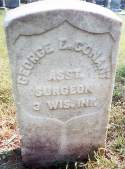
| Description | : | Burial Per The Oak Hill Cemetery Interment Records.∼Abigail Lucinda (Paine) Conant is the second wife of George E. Conant. George E. Conant's first wife was Emily Charity Foote (15 Feb 1809-7 July 1844). She died in Windham, Portage, OH. Abigail Lucinda Paine was married on 5 Apr 1845 to George E. Conant per Ohio Marriage Record. Listed in the 1850 US Census living in Hartford, Washington, WI. Listed in the 1870 and 1880 US Census living in Neosho, Newton, Missouri. |
frequently asked questions (FAQ):
-
Where is Abigail Lucinda Paine Conant's memorial?
Abigail Lucinda Paine Conant's memorial is located at: Oak Hill Cemetery, Lawrence, Douglas County, USA.
-
When did Abigail Lucinda Paine Conant death?
Abigail Lucinda Paine Conant death on 11 Sep 1903 in Oskaloosa, Jefferson County, Kansas, USA
-
Where are the coordinates of the Abigail Lucinda Paine Conant's memorial?
Latitude: 38.9589005
Longitude: -95.2118988
Family Members:
Spouse
Children

Flowers:


Nearby Cemetories:
1. Oak Hill Cemetery
Lawrence, Douglas County, USA
Coordinate: 38.9589005, -95.2118988
2. Mount Calvary Catholic Cemetery
Lawrence, Douglas County, USA
Coordinate: 38.9580002, -95.2139969
3. Memorial Park Cemetery
Lawrence, Douglas County, USA
Coordinate: 38.9552994, -95.2153015
4. Trinity Episcopal Church Columbarium
Lawrence, Douglas County, USA
Coordinate: 38.9653893, -95.2373886
5. Saint Johns Catholic Cemetery
Douglas County, USA
Coordinate: 38.9437900, -95.1919600
6. Dyche Hall Natural History Museum
Lawrence, Douglas County, USA
Coordinate: 38.9584800, -95.2434800
7. Franklin Cemetery
Douglas County, USA
Coordinate: 38.9437523, -95.1869431
8. Haskell Cemetery
Lawrence, Douglas County, USA
Coordinate: 38.9353790, -95.2284241
9. Pioneer Cemetery
Lawrence, Douglas County, USA
Coordinate: 38.9528008, -95.2611008
10. First Presbyterian Church Memorial Garden
Lawrence, Douglas County, USA
Coordinate: 38.9414900, -95.2641600
11. Maple Grove Cemetery
Lawrence, Douglas County, USA
Coordinate: 39.0018997, -95.2316971
12. County Poor Farm Cemetery
Douglas County, USA
Coordinate: 38.9119400, -95.2214600
13. Adams Cemetery
Douglas County, USA
Coordinate: 38.9955400, -95.2509100
14. Kennedy Cemetery
Douglas County, USA
Coordinate: 38.9112900, -95.2269200
15. Davis Cemetery
Lawrence, Douglas County, USA
Coordinate: 38.9722500, -95.2831100
16. Blue Mound Cemetery
Lawrence, Douglas County, USA
Coordinate: 38.9046600, -95.1865400
17. Marshall Cemetery
Douglas County, USA
Coordinate: 38.9040800, -95.2446700
18. Dutton Cemetery
Douglas County, USA
Coordinate: 38.8989800, -95.2790600
19. Luckan Family Cemetery
Fall Leaf, Leavenworth County, USA
Coordinate: 38.9808500, -95.1128000
20. Cemetery Beni Israel
Eudora, Douglas County, USA
Coordinate: 38.9280128, -95.1122208
21. Southwest City Cemetery
Eudora, Douglas County, USA
Coordinate: 38.9334800, -95.1070300
22. Lyon Family Cemetery
Lawrence, Douglas County, USA
Coordinate: 38.9877440, -95.3166530
23. Corpus Christi Catholic Church Columbarium
Lawrence, Douglas County, USA
Coordinate: 38.9572250, -95.3238450
24. Richland Cemetery
Lawrence, Douglas County, USA
Coordinate: 38.8768997, -95.2630997