

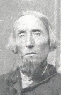
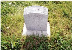
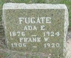
Ada Eliza Doty Fugate
| Birth | : | 28 Nov 1876 Jackson County, Iowa, USA |
| Death | : | 31 Dec 1924 Stanley County, South Dakota, USA |
| Burial | : | Cedar Hill Cemetery, Fort Pierre, Stanley County, USA |
| Coordinate | : | 44.3356018, -100.3964005 |
| Plot | : | Block 100 Lot 2 Grave 1 |
frequently asked questions (FAQ):
-
Where is Ada Eliza Doty Fugate's memorial?
Ada Eliza Doty Fugate's memorial is located at: Cedar Hill Cemetery, Fort Pierre, Stanley County, USA.
-
When did Ada Eliza Doty Fugate death?
Ada Eliza Doty Fugate death on 31 Dec 1924 in Stanley County, South Dakota, USA
-
Where are the coordinates of the Ada Eliza Doty Fugate's memorial?
Latitude: 44.3356018
Longitude: -100.3964005
Family Members:
Parent
Spouse
Siblings

Children


Flowers:


Nearby Cemetories:
1. Cedar Hill Cemetery
Fort Pierre, Stanley County, USA
Coordinate: 44.3356018, -100.3964005
2. South Dakota State Capitol Grounds
Pierre, Hughes County, USA
Coordinate: 44.3660100, -100.3448000
3. Fort Pierre Chouteau Cemetery
Fort Pierre, Stanley County, USA
Coordinate: 44.3908700, -100.3878300
4. Scotty Philip Cemetery
Fort Pierre, Stanley County, USA
Coordinate: 44.4019012, -100.4036026
5. Riverside Cemetery
Pierre, Hughes County, USA
Coordinate: 44.3608017, -100.3071976
6. Mount Calvary Cemetery
Pierre, Hughes County, USA
Coordinate: 44.4197006, -100.3557968
7. Mathews Family Cemetery
Stanley County, USA
Coordinate: 44.1816040, -100.5581080
8. Byron Township Cemetery
Blunt, Hughes County, USA
Coordinate: 44.4979200, -100.1904700
9. Meers Cemetery
Stanley County, USA
Coordinate: 44.4116970, -100.7360760
10. Holy Name Episcopal Cemetery
Fort Pierre, Stanley County, USA
Coordinate: 44.2694960, -100.0357300
11. Holy Name Chapel Cemetery
Fort Pierre, Stanley County, USA
Coordinate: 44.2694292, -100.0356989
12. Canning Cemetery
Hughes County, USA
Coordinate: 44.3986890, -100.0278460
13. Fort Sully Post Cemetery
Sully County, USA
Coordinate: 44.5866480, -100.6087530
14. Okobojo Cemetery
Sully County, USA
Coordinate: 44.6568985, -100.3647003
15. Pleasant Hill Cemetery
Blunt, Hughes County, USA
Coordinate: 44.5135994, -100.0156021
16. Immanuel Lutheran Cemetery
Van Metre, Jones County, USA
Coordinate: 44.0958800, -100.7263300
17. Holy Faith Cemetery
Lyman County, USA
Coordinate: 44.1356010, -99.9878006
18. Fort Bennett Post Cemetery
Stanley County, USA
Coordinate: 44.6716500, -100.6404200
19. Chapelle Cemetery
Hughes County, USA
Coordinate: 44.3025017, -99.8653030
20. Draper Cemetery
Draper, Jones County, USA
Coordinate: 43.9322014, -100.5475006
21. Vivian Cemetery
Vivian, Lyman County, USA
Coordinate: 43.9233017, -100.2652969
22. Onida Cemetery
Onida, Sully County, USA
Coordinate: 44.7147000, -100.0650000
23. Mission Ridge Cemetery
Mission Ridge, Stanley County, USA
Coordinate: 44.6960983, -100.7716980
24. Saint Catherines Cemetery
Harrold, Hughes County, USA
Coordinate: 44.2091100, -99.7868200