
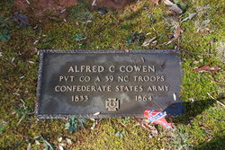
Alfred C. Cowen
| Birth | : | 1833 |
| Death | : | 1864 |
| Burial | : | Cane Creek Baptist Church Cemetery, Union Mills, Rutherford County, USA |
| Coordinate | : | 35.5222250, -81.8530630 |
| Description | : | Private, Company A, 39th North Carolina Troops, Confederate States Army. In 1860 he lived in Whiteside Settlement, Rutherford County (Post Office was First Broad), married to Leonada with children Atkins and Martha. Name listed on census was Cowens. |
frequently asked questions (FAQ):
-
Where is Alfred C. Cowen's memorial?
Alfred C. Cowen's memorial is located at: Cane Creek Baptist Church Cemetery, Union Mills, Rutherford County, USA.
-
When did Alfred C. Cowen death?
Alfred C. Cowen death on 1864 in
-
Where are the coordinates of the Alfred C. Cowen's memorial?
Latitude: 35.5222250
Longitude: -81.8530630
Family Members:
Spouse

Children
Flowers:


Nearby Cemetories:
1. Cane Creek Baptist Church Cemetery
Union Mills, Rutherford County, USA
Coordinate: 35.5222250, -81.8530630
2. Fork Creek Baptist Church Cemetery
Rutherford County, USA
Coordinate: 35.5249710, -81.8802872
3. Weast Cemetery
Sunshine, Rutherford County, USA
Coordinate: 35.5341320, -81.8145960
4. Camp Creek Baptist Church Cemetery
Union Mills, Rutherford County, USA
Coordinate: 35.5141983, -81.9039001
5. Fairview Church Cemetery
Forest City, Rutherford County, USA
Coordinate: 35.5409640, -81.8010940
6. Golden Valley Church of the Brethren Cemetery
Sunshine, Rutherford County, USA
Coordinate: 35.5368800, -81.7974200
7. Mooney-Van Zandt Cemetery
Rutherford County, USA
Coordinate: 35.5335800, -81.7932500
8. Pisgah United Methodist Church Cemetery
Rutherfordton, Rutherford County, USA
Coordinate: 35.4770130, -81.8799750
9. Golden Valley United Methodist Church Cemetery
Bostic, Rutherford County, USA
Coordinate: 35.5203018, -81.7900009
10. Kirksey Family Cemetery
McDowell County, USA
Coordinate: 35.5810600, -81.8431900
11. Sandy Level Baptist Cemetery
Bostic, Rutherford County, USA
Coordinate: 35.4591400, -81.8520440
12. Brackettown Cemetery
McDowell County, USA
Coordinate: 35.5532990, -81.9207993
13. Westminister Baptist Church Cemetery
Rutherfordton, Rutherford County, USA
Coordinate: 35.4647750, -81.8927880
14. Freedom Baptist Church Cemetery
McDowell County, USA
Coordinate: 35.5883900, -81.8445700
15. Epps Family Cemetery
McDowell County, USA
Coordinate: 35.5778020, -81.9016850
16. Cooper Springs Congregational Holiness Church Ceme
Rutherford County, USA
Coordinate: 35.4755700, -81.7844540
17. Fortune Cemetery
Rutherford County, USA
Coordinate: 35.5092010, -81.7647018
18. Poteet Family Cemetery
McDowell County, USA
Coordinate: 35.5774040, -81.9125020
19. Golden Valley Missionary Methodist Church Cemetery
Bostic, Rutherford County, USA
Coordinate: 35.4961700, -81.7678800
20. Brittain Cemetery
Rutherfordton, Rutherford County, USA
Coordinate: 35.4530983, -81.8861008
21. Silver Creek Knob
Burke County, USA
Coordinate: 35.5835000, -81.7970000
22. Pleasant Hill Cemetery
Rutherford County, USA
Coordinate: 35.5022011, -81.9441986
23. Mount Harmony Baptist Church Cemetery
Bostic, Rutherford County, USA
Coordinate: 35.4588380, -81.7996940
24. Trinity United Methodist Church Cemetery
Dysartsville, McDowell County, USA
Coordinate: 35.5995270, -81.8644050