

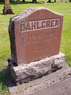
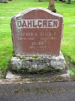
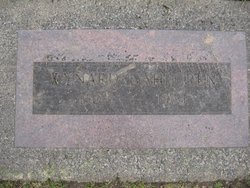
Alfred Eugene Dahlgren
| Birth | : | 4 Dec 1854 Victoria, Knox County, Illinois, USA |
| Death | : | 10 Jan 1921 Kent, King County, Washington, USA |
| Burial | : | Holy Trinity Churchyard, Walton, Mendip District, England |
| Coordinate | : | 51.1236200, -2.7709580 |
| Description | : | According to his Washington State death record, Alfred was the son of Peter Dahlgren. His wife was named Eliza C. Dahlgren. Obit: Kent Advertiser Journal, Jan. 13, 1921, p-1 "Alfred E. Dahlgren Mr. Alfred E. Dahlgren, one of the old citizens of Kent, died at his home on January 10, 1921. The funeral services were conducted by the Rev. Spencer Sulliger, in the Chittenden Parlors, Wednesday, January 12, and interment was in the Kent cemetery. The funeral was largely attended and a profusion of beautiful flowers told of the respect of friends. Mr. Dahlgren was born in Victoria, Illinois, December 4, 1854, and... Read More |
frequently asked questions (FAQ):
-
Where is Alfred Eugene Dahlgren's memorial?
Alfred Eugene Dahlgren's memorial is located at: Holy Trinity Churchyard, Walton, Mendip District, England.
-
When did Alfred Eugene Dahlgren death?
Alfred Eugene Dahlgren death on 10 Jan 1921 in Kent, King County, Washington, USA
-
Where are the coordinates of the Alfred Eugene Dahlgren's memorial?
Latitude: 51.1236200
Longitude: -2.7709580
Family Members:
Parent
Spouse
Siblings
Children


Flowers:


Nearby Cemetories:
1. Holy Trinity Churchyard
Walton, Mendip District, England
Coordinate: 51.1236200, -2.7709580
2. Holy Trinity Churchyard Extension
Walton, Mendip District, England
Coordinate: 51.1234150, -2.7695832
3. Street Cemetery
Street, Mendip District, England
Coordinate: 51.1302840, -2.7508240
4. Religious Society of Friends Quaker Cemetery
Street, Mendip District, England
Coordinate: 51.1294100, -2.7375630
5. All Saint's Churchyard
Ashcott, Sedgemoor District, England
Coordinate: 51.1309220, -2.8058870
6. Holy Trinity Churchyard
Street, Mendip District, England
Coordinate: 51.1310100, -2.7330800
7. Saint Andrew Churchyard
Compton Dundon, South Somerset District, England
Coordinate: 51.0897330, -2.7442800
8. St Benedict Churchyard
Glastonbury, Mendip District, England
Coordinate: 51.1465970, -2.7196900
9. Glastonbury Abbey
Glastonbury, Mendip District, England
Coordinate: 51.1464996, -2.7151000
10. Saint John the Baptist Churchyard
Glastonbury, Mendip District, England
Coordinate: 51.1481520, -2.7161400
11. Blessed Virgin Mary Churchyard
Shapwick, Sedgemoor District, England
Coordinate: 51.1405090, -2.8336100
12. St. Michael and All Angels Churchyard
Greinton, Sedgemoor District, England
Coordinate: 51.1240140, -2.8408590
13. St. Mary & All Saints Churchyard
Meare, Mendip District, England
Coordinate: 51.1715900, -2.7804100
14. Glastonbury Cemetery
Glastonbury, Mendip District, England
Coordinate: 51.1565160, -2.7132380
15. St Leonard Churchyard
Butleigh, Mendip District, England
Coordinate: 51.1025800, -2.6868850
16. Blessed Virgin Mary Churchyard
Moorlinch, Sedgemoor District, England
Coordinate: 51.1280000, -2.8616000
17. St. Andrew's Churchyard
High Ham, South Somerset District, England
Coordinate: 51.0760320, -2.8218400
18. High Ham Cemetery
High Ham, South Somerset District, England
Coordinate: 51.0739931, -2.8216351
19. Holy Trinity Church
Godney, Mendip District, England
Coordinate: 51.1793400, -2.7377400
20. Saint Peter Churchyard
Catcott, Sedgemoor District, England
Coordinate: 51.1494920, -2.8671220
21. Low Ham Church in the Field
High Ham, South Somerset District, England
Coordinate: 51.0583449, -2.8155268
22. St John the Baptist Churchyard
Pitney, South Somerset District, England
Coordinate: 51.0532200, -2.7937320
23. All Saints Churchyard
Kingweston, South Somerset District, England
Coordinate: 51.0793076, -2.6791489
24. St. Dunstan Churchyard
Baltonsborough, Mendip District, England
Coordinate: 51.1107200, -2.6557600