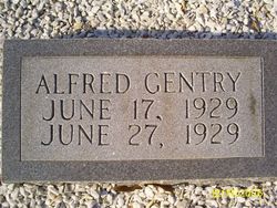
Alfred Gentry
| Birth | : | 17 Jun 1929 |
| Death | : | 27 Jun 1929 |
| Burial | : | St Mary the Virgin Churchyard, Chalk, Gravesham Borough, England |
| Coordinate | : | 51.4265213, 0.4195510 |
frequently asked questions (FAQ):
-
Where is Alfred Gentry's memorial?
Alfred Gentry's memorial is located at: St Mary the Virgin Churchyard, Chalk, Gravesham Borough, England.
-
When did Alfred Gentry death?
Alfred Gentry death on 27 Jun 1929 in
-
Where are the coordinates of the Alfred Gentry's memorial?
Latitude: 51.4265213
Longitude: 0.4195510
Family Members:
Parent
Siblings
Flowers:
Nearby Cemetories:
1. St Mary the Virgin Churchyard
Chalk, Gravesham Borough, England
Coordinate: 51.4265213, 0.4195510
2. St Peter and St Paul Churchyard
Shorne, Gravesham Borough, England
Coordinate: 51.4132347, 0.4297970
3. Milton-next-Gravesend War Memorial
Gravesend, Gravesham Borough, England
Coordinate: 51.4389950, 0.3896110
4. St. Peter and St. Paul Churchyard
Gravesend, Gravesham Borough, England
Coordinate: 51.4391441, 0.3854820
5. Christ Church Milton-next-Gravesend
Gravesend, Gravesham Borough, England
Coordinate: 51.4317570, 0.3769340
6. St John Evangelist Churchyard
Higham, Gravesham Borough, England
Coordinate: 51.4162102, 0.4616890
7. Gravesend War Memorial
Gravesend, Gravesham Borough, England
Coordinate: 51.4362650, 0.3720650
8. Gravesend Methodist Churchyard
Gravesend, Gravesham Borough, England
Coordinate: 51.4418776, 0.3721993
9. St Mary Churchyard
Higham, Gravesham Borough, England
Coordinate: 51.4408760, 0.4682570
10. St. Margaret Churchyard
Cobham, Gravesham Borough, England
Coordinate: 51.4059906, 0.3749080
11. St George Churchyard
Gravesend, Gravesham Borough, England
Coordinate: 51.4441060, 0.3683350
12. Cobham War Memorial
Cobham, Gravesham Borough, England
Coordinate: 51.3900719, 0.4043670
13. Gravesend Cemetery
Gravesend, Gravesham Borough, England
Coordinate: 51.4345220, 0.3596280
14. Tilbury Fort
Tilbury, Thurrock Unitary Authority, England
Coordinate: 51.4526160, 0.3745650
15. St. Mary Magdalene New Churchyard
Cobham, Gravesham Borough, England
Coordinate: 51.3899060, 0.3983090
16. St. Catherine's Churchyard
East Tilbury, Thurrock Unitary Authority, England
Coordinate: 51.4664730, 0.4303230
17. All Saints Churchyard
Northfleet, Gravesham Borough, England
Coordinate: 51.4334679, 0.3513570
18. St James Churchyard
West Tilbury, Thurrock Unitary Authority, England
Coordinate: 51.4739320, 0.3908730
19. St Mildred Churchyard
Nurstead, Gravesham Borough, England
Coordinate: 51.3902931, 0.3574180
20. Strood Cemetery
Strood, Medway Unitary Authority, England
Coordinate: 51.3900220, 0.4838640
21. Northfleet Cemetery
Northfleet, Gravesham Borough, England
Coordinate: 51.4345551, 0.3333960
22. St Nicholas with St Mary Churchyard
Strood, Medway Unitary Authority, England
Coordinate: 51.3959790, 0.4931350
23. St Botolph Churchyard
Northfleet, Gravesham Borough, England
Coordinate: 51.4429910, 0.3347090
24. St Peter and St Paul Churchyard
Luddesdown, Gravesham Borough, England
Coordinate: 51.3700218, 0.3974010

