
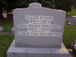

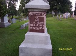
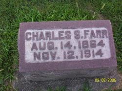
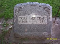
Allen S. Farr
| Birth | : | 27 Aug 1861 Noble Township, Wabash County, Indiana, USA |
| Death | : | 17 Sep 1913 Noble Township, Wabash County, Indiana, USA |
| Burial | : | St Michael Churchyard, Kirkham, Fylde Borough, England |
| Coordinate | : | 53.7843570, -2.8709520 |
| Plot | : | Sec D, lot 63, sp 4 |
| Description | : | 1880: Residing w widowed mother, Noble Twsp, Wabash County, Indiana. Single. Occupation: Works on farm. Married Emma Bruner on 21 November 1883 in Wabash County, Indiana. 1900: Residing Noble Twsp, Wabash County, Indiana. Husband of Emma; parents of Harry. Occupation: Farmer. 1910: Residing Noble Twsp, Wabash County, Indiana. Husband of Emma; parents of Harry. Occupation: Farmer. |
frequently asked questions (FAQ):
-
Where is Allen S. Farr's memorial?
Allen S. Farr's memorial is located at: St Michael Churchyard, Kirkham, Fylde Borough, England.
-
When did Allen S. Farr death?
Allen S. Farr death on 17 Sep 1913 in Noble Township, Wabash County, Indiana, USA
-
Where are the coordinates of the Allen S. Farr's memorial?
Latitude: 53.7843570
Longitude: -2.8709520
Family Members:
Parent

Spouse
Siblings
Children

Flowers:


Nearby Cemetories:
1. St Michael Churchyard
Kirkham, Fylde Borough, England
Coordinate: 53.7843570, -2.8709520
2. Zion Chapel Cemetery
Kirkham, Fylde Borough, England
Coordinate: 53.7814380, -2.8721260
3. Christ Church Churchyard
Wesham, Fylde Borough, England
Coordinate: 53.7905000, -2.8845600
4. Saint John the Evangelist Churchyard
Kirkham, Fylde Borough, England
Coordinate: 53.7808000, -2.8873870
5. Saint Joseph's Roman Catholic Church
Wesham, Fylde Borough, England
Coordinate: 53.7928600, -2.8871800
6. Quakers Wood Burial Ground
Freckleton, Fylde Borough, England
Coordinate: 53.7652227, -2.8601674
7. Christ Churchyard
Treales, Fylde Borough, England
Coordinate: 53.8045970, -2.8440710
8. St Nicholas Churchyard
Wrea Green, Fylde Borough, England
Coordinate: 53.7772420, -2.9156380
9. Holy Trinity Churchyard
Freckleton, Fylde Borough, England
Coordinate: 53.7543090, -2.8669130
10. St. Anne's Roman Catholic Churchyard
Westby, Fylde Borough, England
Coordinate: 53.7876590, -2.9247000
11. St. John the Evangelist Churchyard
Clifton, Fylde Borough, England
Coordinate: 53.7758600, -2.8158500
12. Parish Church of St. Paul
Warton, Fylde Borough, England
Coordinate: 53.7502621, -2.8932641
13. St Michael Churchyard
Weeton, Fylde Borough, England
Coordinate: 53.7995380, -2.9358020
14. St. Mary's Churchyard
Lea, City of Preston, England
Coordinate: 53.7733810, -2.7942770
15. Elswick Congregational Chapelyard
Elswick, Fylde Borough, England
Coordinate: 53.8378950, -2.8775320
16. Inskip Baptist Churchyard
Inskip with Sowerby, Wyre Borough, England
Coordinate: 53.8353150, -2.8299610
17. Saltcoates Roman Catholic Cemetery
Lytham Saint Annes, Fylde Borough, England
Coordinate: 53.7463000, -2.9448940
18. St. Peters Churchyard
Inskip with Sowerby, Wyre Borough, England
Coordinate: 53.8347100, -2.8175200
19. St Anne Churchyard
Great Eccleston, Wyre Borough, England
Coordinate: 53.8481413, -2.8835925
20. St Anne Churchyard
Singleton, Fylde Borough, England
Coordinate: 53.8379280, -2.9359890
21. St Andrew George Haydock Roman Catholic Churchyard
Cottam, City of Preston, England
Coordinate: 53.7879280, -2.7591570
22. St. Anne's Churchyard
Blackburn, Blackburn with Darwen Unitary Authority, England
Coordinate: 53.8381160, -2.9362870
23. Saint Anne's Church
Woodplumpton, City of Preston, England
Coordinate: 53.8038130, -2.7621940
24. St John the Divine
Lytham Saint Annes, Fylde Borough, England
Coordinate: 53.7367060, -2.9548070