
| Memorials | : | 425 |
| Location | : | Inskip with Sowerby, Wyre Borough, England |
| Coordinate | : | 53.8347100, -2.8175200 |
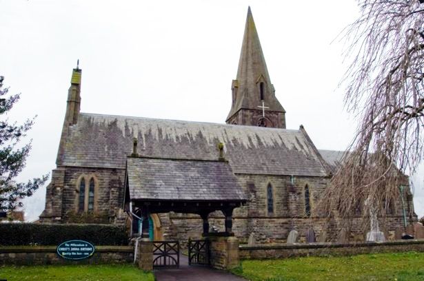
| Description | : | The foundation stone of the dedication of St. Peter's Church was laid on June 10, 1847 and was financed by Edward Smith-Stanley, 13th Earl of Derby. The oldest part of the church was built in limestone with sandstone trim and a state roof. The chancel and steeple were added in 1925. Inskip is a small village in the Fylde area of Lancashire and has been documented in this location since 1089. It is near to the RNAS Inskip airfield, “HMS Nightjar,” serving military as a tri-service communication center during World War I and World War II. The churchyard cemetery has... Read More |
frequently asked questions (FAQ):
-
Where is St. Peters Churchyard?
St. Peters Churchyard is located at Inskip with Sowerby, Wyre Borough ,Lancashire ,England.
-
St. Peters Churchyard cemetery's updated grave count on graveviews.com?
424 memorials
-
Where are the coordinates of the St. Peters Churchyard?
Latitude: 53.8347100
Longitude: -2.8175200
Nearby Cemetories:
1. Inskip Baptist Churchyard
Inskip with Sowerby, Wyre Borough, England
Coordinate: 53.8353150, -2.8299610
2. St. Michael’s Churchyard
St Michael's on Wyre, Wyre Borough, England
Coordinate: 53.8628050, -2.8195430
3. Christ Churchyard
Treales, Fylde Borough, England
Coordinate: 53.8045970, -2.8440710
4. Elswick Congregational Chapelyard
Elswick, Fylde Borough, England
Coordinate: 53.8378950, -2.8775320
5. St Mary Roman Catholic Churchyard
Great Eccleston, Wyre Borough, England
Coordinate: 53.8535420, -2.8710090
6. St Anne Churchyard
Great Eccleston, Wyre Borough, England
Coordinate: 53.8481413, -2.8835925
7. Saint Anne's Church
Woodplumpton, City of Preston, England
Coordinate: 53.8038130, -2.7621940
8. St. Helen's Churchyard
Kirkland (Churchtown), Wyre Borough, England
Coordinate: 53.8790700, -2.7901000
9. St Mary's Newhouse
Barton, City of Preston, England
Coordinate: 53.8205240, -2.7406500
10. St. Hilda's Churchyard
Bilsborrow, Wyre Borough, England
Coordinate: 53.8522170, -2.7420090
11. St. Lawrence Churchyard
Barton, City of Preston, England
Coordinate: 53.8289213, -2.7366654
12. St Andrew George Haydock Roman Catholic Churchyard
Cottam, City of Preston, England
Coordinate: 53.7879280, -2.7591570
13. Saint Joseph's Roman Catholic Church
Wesham, Fylde Borough, England
Coordinate: 53.7928600, -2.8871800
14. St. John the Evangelist Churchyard
Clifton, Fylde Borough, England
Coordinate: 53.7758600, -2.8158500
15. Christ Church Churchyard
Wesham, Fylde Borough, England
Coordinate: 53.7905000, -2.8845600
16. St Michael Churchyard
Kirkham, Fylde Borough, England
Coordinate: 53.7843570, -2.8709520
17. St. John’s Churchyard
Out Rawcliffe, Wyre Borough, England
Coordinate: 53.8741650, -2.8959310
18. Kirkland Strict and Particular Baptist Chapel
Nateby, Wyre Borough, England
Coordinate: 53.8961210, -2.8170130
19. Zion Chapel Cemetery
Kirkham, Fylde Borough, England
Coordinate: 53.7814380, -2.8721260
20. St. Mary's Churchyard
Lea, City of Preston, England
Coordinate: 53.7733810, -2.7942770
21. St. John Baptist Churchyard
Broughton-in-Amounderness, City of Preston, England
Coordinate: 53.8033700, -2.7170400
22. Saint John the Evangelist Churchyard
Kirkham, Fylde Borough, England
Coordinate: 53.7808000, -2.8873870
23. St Mary and St Michael Catholic Churchyard
Garstang, Wyre Borough, England
Coordinate: 53.8975610, -2.7706170
24. St. Thomas Churchyard
Garstang, Wyre Borough, England
Coordinate: 53.8992300, -2.7764500