
| Birth | : | 7 Dec 1859 Rexton, Kent County, New Brunswick, Canada |
| Death | : | 19 Nov 1927 Dalhousie, Restigouche County, New Brunswick, Canada |
| Burial | : | Saint Andrew's United Church Cemetery, Rexton, Kent County, Canada |
| Coordinate | : | 46.6478700, -64.8724000 |
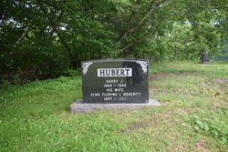
| Inscription | : | Doherty W.W.Doherty M.D 1859-1916 His Wife Alma Girvan 1864-1927 |
| Description | : | Birth 7 December 1859 • Rexton, New Brunwick, Canada Alma's birth date is given as 7 December 1964 in other documents, including her death certificate. However, the fact that she is recorded in the 1861 census would indicate an earlier DOB; therefore, I am using 1859 here. Marriage September 1886 • Rexton, Kent County, New Brunswick Article Saint John "Daily Telegraph" 17 Sep 1886:"m. Presbyterian Church, Kingston (Kent Co.) by Rev. Wm Hamilton, Wm W. DOHERTY, Esq., M.D., Dalhousie (Rest. Co.) / Alma girvan youngest d/o Alexander girvan, Esq. " Dr. William Woodbury Doherty |
frequently asked questions (FAQ):
-
Where is Alma Girvan Doherty's memorial?
Alma Girvan Doherty's memorial is located at: Saint Andrew's United Church Cemetery, Rexton, Kent County, Canada.
-
When did Alma Girvan Doherty death?
Alma Girvan Doherty death on 19 Nov 1927 in Dalhousie, Restigouche County, New Brunswick, Canada
-
Where are the coordinates of the Alma Girvan Doherty's memorial?
Latitude: 46.6478700
Longitude: -64.8724000
Family Members:
Parent

Spouse
Siblings
Children
Flowers:


Nearby Cemetories:
1. Saint Andrew's United Church Cemetery
Rexton, Kent County, Canada
Coordinate: 46.6478700, -64.8724000
2. Immaculate Conception Roman Catholic Cemetery
Rexton, Kent County, Canada
Coordinate: 46.6400100, -64.8712200
3. Richibucto Protestant Cemetery
Richibucto, Kent County, Canada
Coordinate: 46.6730300, -64.8677700
4. Galloway Cemetery
West Galloway, Kent County, Canada
Coordinate: 46.6124320, -64.8520750
5. Saint Louis de Gonzague
Richibucto, Kent County, Canada
Coordinate: 46.6882680, -64.8624160
6. Methodist Point Cemetery
Rexton, Kent County, Canada
Coordinate: 46.6042300, -64.9165060
7. Chapel Point Cemetery
Richibucto, Kent County, Canada
Coordinate: 46.5966300, -64.9202300
8. Aldouane Roman Catholic Cemetery
Aldouane, Kent County, Canada
Coordinate: 46.7098670, -64.8985700
9. St. Charles Roman Catholic Cemetery
Saint-Charles, Kent County, Canada
Coordinate: 46.6689480, -64.9729100
10. Saint Antoine de Padoue
Richibucto, Kent County, Canada
Coordinate: 46.6568030, -64.7537160
11. Saint Anne's Roman Catholic Cemetery
Big Cove, Kent County, Canada
Coordinate: 46.5854736, -64.9864107
12. Kingdom Hall of Jehovah's Witnesses Cemetery
West Branch, Kent County, Canada
Coordinate: 46.5497546, -64.9345299
13. Saint-Louis-de-Kent Catholic Cemetery
Saint-Louis de Kent, Kent County, Canada
Coordinate: 46.7284860, -64.9799050
14. Saint Anne Roman Catholic Cemetery
Sainte-Anne-de-Kent, Kent County, Canada
Coordinate: 46.5509000, -64.7738340
15. West Branch Presbyterian Cemetery
West Branch, Kent County, Canada
Coordinate: 46.5410340, -64.9480820
16. Saint John's United Church Cemetery
West Branch, Kent County, Canada
Coordinate: 46.5339660, -64.9571180
17. St. Stephens United Church Cemetery
Molus River, Kent County, Canada
Coordinate: 46.5763290, -65.0817130
18. St. Bartholomew's Roman Catholic Cemetery
Molus River, Kent County, Canada
Coordinate: 46.5739550, -65.0830720
19. Old MacIntosh Hill Burial Ground
Kent County, Canada
Coordinate: 46.5031240, -64.7459570
20. St. Mark's Presbyterian Cemetery
Bass River, Kent County, Canada
Coordinate: 46.5424130, -65.0894630
21. Saint Bartholomew Roman Catholic Cemetery
Bass River, Kent County, Canada
Coordinate: 46.5539410, -65.1073140
22. (New) Bouctouche Roman Catholic Cemetery
Bouctouche, Kent County, Canada
Coordinate: 46.5104850, -64.6827398
23. Saint-Norbert Parish Cemetery
Saint-Norbert, Kent County, Canada
Coordinate: 46.4662200, -64.9683100
24. Knox Presbyterian Cemetery
Kouchibouguac, Kent County, Canada
Coordinate: 46.7938700, -65.0578100