

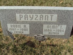
Alma Therese Nollmann Payzant
| Birth | : | 26 Dec 1886 Omaha, Douglas County, Nebraska, USA |
| Death | : | 4 Aug 1964 Minatare, Scotts Bluff County, Nebraska, USA |
| Burial | : | Desert Lawn Memorial Park, Yuma, Yuma County, USA |
| Coordinate | : | 32.7016983, -114.6175003 |
| Description | : | Daughter of William Henry and Francesca Theresa (Herrmann) Nollmann. Married to Robie Arthur Payzant 26 Feb 1920 in Omaha, NE. Mother of Frances Mary Payzant. |
frequently asked questions (FAQ):
-
Where is Alma Therese Nollmann Payzant's memorial?
Alma Therese Nollmann Payzant's memorial is located at: Desert Lawn Memorial Park, Yuma, Yuma County, USA.
-
When did Alma Therese Nollmann Payzant death?
Alma Therese Nollmann Payzant death on 4 Aug 1964 in Minatare, Scotts Bluff County, Nebraska, USA
-
Where are the coordinates of the Alma Therese Nollmann Payzant's memorial?
Latitude: 32.7016983
Longitude: -114.6175003
Family Members:
Flowers:


Nearby Cemetories:
1. Yuma Pioneer Cemetery
Yuma, Yuma County, USA
Coordinate: 32.7042007, -114.6177979
2. Saint Pauls Episcopal Church Columbarium
Yuma, Yuma County, USA
Coordinate: 32.6992000, -114.6380000
3. Faith Lutheran Church Columbarium
Yuma, Yuma County, USA
Coordinate: 32.6862500, -114.6284900
4. Yuma Territorial Prison State Historic Park
Yuma, Yuma County, USA
Coordinate: 32.7262000, -114.6134000
5. Christ Lutheran Church Columbarium
Yuma, Yuma County, USA
Coordinate: 32.6813300, -114.5940800
6. Trinity United Methodist Church Columbarium
Yuma, Yuma County, USA
Coordinate: 32.6726400, -114.6290600
7. Fort Yuma Post
Winterhaven, Imperial County, USA
Coordinate: 32.7387790, -114.6142540
8. Quechan Indian Cemetery
Winterhaven, Imperial County, USA
Coordinate: 32.7395962, -114.6147566
9. Panteón Ejido Culiacán
Vicente Guerrero, Ensenada Municipality, Mexico
Coordinate: 32.7119410, -114.7548960
10. East Cocopah Indian Reservation Cemetery
Somerton, Yuma County, USA
Coordinate: 32.5743500, -114.6740700
11. Laguna Cemetery
Laguna, Yuma County, USA
Coordinate: 32.8017113, -114.4963377
12. Potholes Cemetery
Bard, Imperial County, USA
Coordinate: 32.8171997, -114.5119019
13. West Cocopah Indian Reservation Cemetery
Somerton, Yuma County, USA
Coordinate: 32.6152000, -114.7638390
14. Gloria de Cristo Lutheran Church Columbarium
Yuma, Yuma County, USA
Coordinate: 32.6553600, -114.4404100
15. Sunset Vista Funeral Home & Cemetery
Yuma, Yuma County, USA
Coordinate: 32.6548000, -114.4386000
16. Saint John Neumann Catholic Church Columbarium
Yuma, Yuma County, USA
Coordinate: 32.6550700, -114.4368200
17. Ogilby Cemetery
Ogilby, Imperial County, USA
Coordinate: 32.8152300, -114.8389400
18. Panteón Ejidal Morelos Arnulfo Meza Villegas
Cuervos, Mexicali Municipality, Mexico
Coordinate: 32.6159060, -114.8566100
19. Dome Cemetery
Yuma County, USA
Coordinate: 32.7558500, -114.3652170
20. Panteón de Ejido Mérida
Merida, Mexicali Municipality, Mexico
Coordinate: 32.6518250, -114.9065090
21. Hedges Cemetery
Imperial County, USA
Coordinate: 32.8843994, -114.8302994
22. Panteón Municipal Consejo
San Luis Rio Colorado, San Luis Río Colorado Municipality, Mexico
Coordinate: 32.4619110, -114.7321960
23. Picacho Mine Cemetery
Picacho, Imperial County, USA
Coordinate: 32.9665000, -114.6375500
24. Picacho Cemetery
Imperial County, USA
Coordinate: 33.0207280, -114.6177150