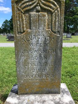
Alvacinda Reed Smith
| Birth | : | 13 Jan 1811 Caledonia, Washington County, Missouri, USA |
| Death | : | 13 Jan 1878 Arkansas, USA |
| Burial | : | Park View Cemetery, Medford, Burlington County, USA |
| Coordinate | : | 39.8983955, -74.8207779 |
| Plot | : | Addition: Original #3; Section: 7; Plot: 1 |
| Description | : | James W. Smith married Alvacinda Reed 31 December 1830 by James M.Black, MG in Hempstead County, Texas. She was the daughter of Thomas Reed and Rebeccas Sloan Reed are on the 1850 US Census in Bois d'Arc Township, Hempstead County, Arkansas. Her younger brother David Clark Reed has a Find A Grave memorial#28681581.She also had a younger brother Robert S. Reed who married Emily Jane Dooley of Texas on 24 July 1851 by John D. Trimble Judge in Hempstead County, Arkansas. Robert and his wife migrated to Lamar County, Texas where he died ca 1900. [Thank you Contributor: Richard G.... Read More |
frequently asked questions (FAQ):
-
Where is Alvacinda Reed Smith's memorial?
Alvacinda Reed Smith's memorial is located at: Park View Cemetery, Medford, Burlington County, USA.
-
When did Alvacinda Reed Smith death?
Alvacinda Reed Smith death on 13 Jan 1878 in Arkansas, USA
-
Where are the coordinates of the Alvacinda Reed Smith's memorial?
Latitude: 39.8983955
Longitude: -74.8207779
Family Members:
Children
Flowers:
Nearby Cemetories:
1. Park View Cemetery
Medford, Burlington County, USA
Coordinate: 39.8983955, -74.8207779
2. Medford Friends Hicksite Burial Ground
Medford, Burlington County, USA
Coordinate: 39.8978940, -74.8219260
3. Medford Baptist Cemetery
Medford, Burlington County, USA
Coordinate: 39.8997536, -74.8187943
4. Medford Methodist Cemetery
Medford, Burlington County, USA
Coordinate: 39.9008408, -74.8200302
5. Medford Friends Meeting Cemetery
Medford, Burlington County, USA
Coordinate: 39.8992081, -74.8255463
6. Stratton Burying Ground
Medford, Burlington County, USA
Coordinate: 39.8839836, -74.8203583
7. Saint Peters Episcopal Church Garden
Medford, Burlington County, USA
Coordinate: 39.8849360, -74.8337860
8. Peacock Cemetery
Chairville, Burlington County, USA
Coordinate: 39.8988991, -74.7889023
9. Park View Cemetery at Kirbys Mill
Medford, Burlington County, USA
Coordinate: 39.9222300, -74.8076800
10. Haines Family Farm Cemetery
Medford, Burlington County, USA
Coordinate: 39.9235020, -74.8079980
11. Mount Laurel Friends Burying Ground
Mount Laurel, Burlington County, USA
Coordinate: 39.9286000, -74.8853920
12. Jacob's Chapel Cemetery
Mount Laurel, Burlington County, USA
Coordinate: 39.9297670, -74.8852350
13. Evergreen Cemetery
Lumberton, Burlington County, USA
Coordinate: 39.9562988, -74.8094025
14. Saint Martin in the Fields Memorial Garden
Lumberton, Burlington County, USA
Coordinate: 39.9581480, -74.8081230
15. Vincentown Baptist Cemetery
Vincentown, Burlington County, USA
Coordinate: 39.9395400, -74.7609690
16. Old Lumberton Cemetery
Lumberton, Burlington County, USA
Coordinate: 39.9590988, -74.8058014
17. Eldridge Cemetery
Mount Laurel, Burlington County, USA
Coordinate: 39.9268837, -74.8968887
18. Evesham Friends Cemetery
Mount Laurel, Burlington County, USA
Coordinate: 39.9351130, -74.8915510
19. Mount Laurel Cemetery
Mount Laurel, Burlington County, USA
Coordinate: 39.9272003, -74.8977966
20. Vincentown Friends Cemetery
Vincentown, Burlington County, USA
Coordinate: 39.9352400, -74.7495500
21. Lord of Life Memorial Garden
Tabernacle, Burlington County, USA
Coordinate: 39.8510860, -74.7590690
22. Vincentown Methodist Cemetery
Vincentown, Burlington County, USA
Coordinate: 39.9370900, -74.7488600
23. Marlton Cemetery
Marlton, Burlington County, USA
Coordinate: 39.8767320, -74.9039320
24. Darnell Family Cemetery
Mount Laurel, Burlington County, USA
Coordinate: 39.9535520, -74.8728800


