
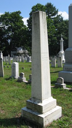
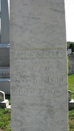
Amos Slate
| Birth | : | 13 Apr 1773 Bernardston, Franklin County, Massachusetts, USA |
| Death | : | 3 Mar 1830 Gill, Franklin County, Massachusetts, USA |
| Burial | : | Center Cemetery, Bernardston, Franklin County, USA |
| Coordinate | : | 42.6695213, -72.5498505 |
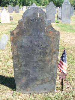
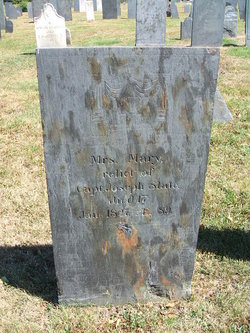
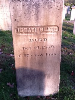
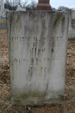
| Description | : | Son of Capt Joseph Slate and Mary White. Husband of Eshter A. Haws (1777-1857) Amos", b. Apr. 13, 1773; m. May 28, 1795, Esther Haws. She d. Jan. 20, 1857, ae. 80. He d. March 3, 1830, from the effects of an injury received the preceding October by the falling of a well sweep. While in Bern, his occupation was that of a miller; d. in Gill. Had: 1. Joel Amos, b. Mch. 14, 1796; m. (?) Apr; 16, 1828, Wealthy Sykes; d. in Northampton Aug. 6, 1866. 2. Erastus, b. Feb. 12, 1798; was a shoe merchant in... Read More |
frequently asked questions (FAQ):
-
Where is Amos Slate's memorial?
Amos Slate's memorial is located at: Center Cemetery, Bernardston, Franklin County, USA.
-
When did Amos Slate death?
Amos Slate death on 3 Mar 1830 in Gill, Franklin County, Massachusetts, USA
-
Where are the coordinates of the Amos Slate's memorial?
Latitude: 42.6695213
Longitude: -72.5498505
Family Members:
Parent
Spouse
Siblings

Children
Flowers:


Nearby Cemetories:
1. Center Cemetery
Bernardston, Franklin County, USA
Coordinate: 42.6695213, -72.5498505
2. Old Cemetery
Bernardston, Franklin County, USA
Coordinate: 42.6810989, -72.5444031
3. Hessian Cemetery
Bernardston, Franklin County, USA
Coordinate: 42.6679174, -72.5897169
4. West Gill Cemetery
Gill, Franklin County, USA
Coordinate: 42.6442700, -72.5280500
5. Greenfield Hebrew Congregation Cemetery
Greenfield, Franklin County, USA
Coordinate: 42.6409410, -72.5653360
6. Log Plain Cemetery
Greenfield, Franklin County, USA
Coordinate: 42.6378320, -72.5725800
7. East Hill Cemetery
Leyden, Franklin County, USA
Coordinate: 42.6931000, -72.6025009
8. Gill Center Cemetery
Gill, Franklin County, USA
Coordinate: 42.6413803, -72.4983063
9. Mount Hermon Cemetery
Northfield, Franklin County, USA
Coordinate: 42.6790800, -72.4821100
10. North Cemetery
Gill, Franklin County, USA
Coordinate: 42.6514160, -72.4817630
11. Riverside Cemetery
Gill, Franklin County, USA
Coordinate: 42.6156006, -72.5410995
12. Country Farms Cemetery
Greenfield, Franklin County, USA
Coordinate: 42.6393900, -72.6165400
13. South Leyden Cemetery
Leyden, Franklin County, USA
Coordinate: 42.6831400, -72.6311200
14. High Street Cemetery
Greenfield, Franklin County, USA
Coordinate: 42.6044840, -72.5806660
15. Center Cemetery
Northfield, Franklin County, USA
Coordinate: 42.6954308, -72.4613342
16. Beaver Meadow Cemetery
Leyden, Franklin County, USA
Coordinate: 42.7188988, -72.6183014
17. Beers Ambush Gravesite
Northfield, Franklin County, USA
Coordinate: 42.6501200, -72.4560300
18. West Northfield Cemetery
Northfield, Franklin County, USA
Coordinate: 42.7117004, -72.4689026
19. Tyler Cemetery
Vernon, Windham County, USA
Coordinate: 42.7344017, -72.4972000
20. Pentecost Cemetery
Northfield, Franklin County, USA
Coordinate: 42.7010200, -72.4539900
21. Fairway Avenue Cemetery
Montague, Franklin County, USA
Coordinate: 42.5924270, -72.5646970
22. Durkee Burial Lot
Northfield, Franklin County, USA
Coordinate: 42.6070000, -72.4861000
23. Saint Marys Cemetery
Northfield, Franklin County, USA
Coordinate: 42.6868910, -72.4448190
24. Northfield Farms Cemetery
Northfield, Franklin County, USA
Coordinate: 42.6124992, -72.4741974