
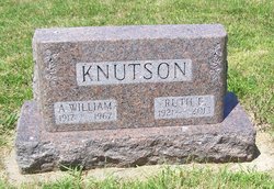
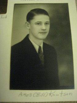
Amos William “Sonny” Knutson
| Birth | : | 10 Aug 1917 Estherville, Emmet County, Iowa, USA |
| Death | : | 22 Nov 1967 Dickinson County, Iowa, USA |
| Burial | : | Palestine Cemetery, Dolliver, Emmet County, USA |
| Coordinate | : | 43.4880000, -94.6408000 |
| Description | : | Bill Knutson Killed in Farm Mishap Spirit Lake - Amos William (Bill) Knutson, 50, well-known Spirit Lake area farmer, was killed about 3 p.m. Wednesday when his clothing became tangled in a power take-off on a hay baler. Investigating authorities said he was killed almost instantly. Funeral services will be held at 2 p.m. Saturday at Union State Line Lutheran Church, Petersburg. Burial will be at Palestine Lutheran Cemetery near Dolliver. Survivors include his wife, two daughters, Rhonda and Kathryn, both college students, and a son, Roger, of Estherville. The Knutsons reside on a farm five miles east and two and one half miles north... Read More |
frequently asked questions (FAQ):
-
Where is Amos William “Sonny” Knutson's memorial?
Amos William “Sonny” Knutson's memorial is located at: Palestine Cemetery, Dolliver, Emmet County, USA.
-
When did Amos William “Sonny” Knutson death?
Amos William “Sonny” Knutson death on 22 Nov 1967 in Dickinson County, Iowa, USA
-
Where are the coordinates of the Amos William “Sonny” Knutson's memorial?
Latitude: 43.4880000
Longitude: -94.6408000
Family Members:
Parent

Spouse

Children
Flowers:


Nearby Cemetories:
1. Palestine Cemetery
Dolliver, Emmet County, USA
Coordinate: 43.4880000, -94.6408000
2. Lincoln Township Cemetery
Dolliver, Emmet County, USA
Coordinate: 43.4441986, -94.6204987
3. Lake Belt Cemetery
Ceylon, Martin County, USA
Coordinate: 43.5353012, -94.6742020
4. Tenhassen Cemetery
Ceylon, Martin County, USA
Coordinate: 43.5293999, -94.5877991
5. Ellsworth Cemetery
Emmet County, USA
Coordinate: 43.5005989, -94.7249985
6. German Evangelical Cemetery
Wilbert, Martin County, USA
Coordinate: 43.5325600, -94.5419000
7. Saint Pauls Lutheran Church Cemetery
Wilbert, Martin County, USA
Coordinate: 43.5444500, -94.5395800
8. Swan Lake Township Cemetery
Maple Hill, Emmet County, USA
Coordinate: 43.3850746, -94.6381378
9. Prosser Cemetery
Estherville, Emmet County, USA
Coordinate: 43.4422000, -94.7783000
10. Lake Fremont Cemetery
Dunnell, Martin County, USA
Coordinate: 43.5691986, -94.7746964
11. Center Township Cemetery
Emmet County, USA
Coordinate: 43.3608000, -94.6790000
12. Armstrong Grove Cemetery
Armstrong, Emmet County, USA
Coordinate: 43.3985696, -94.5041425
13. Saint Marys Catholic Cemetery
Armstrong, Emmet County, USA
Coordinate: 43.3980000, -94.5048000
14. Lone Cedar Cemetery
Sherburn, Martin County, USA
Coordinate: 43.6166992, -94.7144012
15. Mount Calvary Cemetery
Armstrong, Emmet County, USA
Coordinate: 43.3850000, -94.5028000
16. Center Chain Cemetery
Martin County, USA
Coordinate: 43.5224991, -94.4483032
17. Estherville Lutheran Cemetery
Estherville, Emmet County, USA
Coordinate: 43.4298000, -94.8263000
18. Norwegian Cemetery
Estherville, Emmet County, USA
Coordinate: 43.4291992, -94.8261032
19. East Side Memorial Cemetery
Estherville, Emmet County, USA
Coordinate: 43.4267750, -94.8265600
20. East Side Cemetery
Estherville, Emmet County, USA
Coordinate: 43.4068985, -94.8264008
21. Sherburn Cemetery
Sherburn, Martin County, USA
Coordinate: 43.6455612, -94.7275009
22. Saint Patricks Cemetery
Estherville, Emmet County, USA
Coordinate: 43.3843994, -94.8283005
23. Saint Lukes Cemetery
Sherburn, Martin County, USA
Coordinate: 43.6530120, -94.7133132
24. Oak Hill Cemetery
Estherville, Emmet County, USA
Coordinate: 43.3986015, -94.8518982