
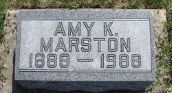


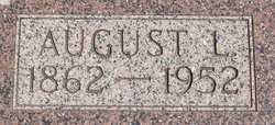
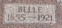
Amy Katherine Meier Marston
| Birth | : | 9 Mar 1888 Allamakee County, Iowa, USA |
| Death | : | 12 Apr 1988 Allamakee County, Iowa, USA |
| Burial | : | St Johns Roman Catholic Church Cemetery, Poulton-le-Fylde, Wyre Borough, England |
| Coordinate | : | 53.8520854, -2.9873511 |
| Description | : | Amy Katherine, daughter of August and Belle (Seitz) Meier, was born March 9, 1888 on a farm near Postville, Iowa. She died Tuesday evening, April 12, 1988 at the Good Samaritan Center, Postville, Iowa. She was baptized and confirmed in the Methodist Episcopal Church. After graduating from the Postville High School in 1904, she attended Cornell College. She graduated from the University of Wisconsin, in Madison in 1910. She also attended the Gregg College of Business in Chicago in 1918. Amy began her teaching career at the Woodland School and the Postville High School. She also taught school in various... Read More |
frequently asked questions (FAQ):
-
Where is Amy Katherine Meier Marston's memorial?
Amy Katherine Meier Marston's memorial is located at: St Johns Roman Catholic Church Cemetery, Poulton-le-Fylde, Wyre Borough, England.
-
When did Amy Katherine Meier Marston death?
Amy Katherine Meier Marston death on 12 Apr 1988 in Allamakee County, Iowa, USA
-
Where are the coordinates of the Amy Katherine Meier Marston's memorial?
Latitude: 53.8520854
Longitude: -2.9873511
Family Members:
Parent
Spouse
Flowers:


Nearby Cemetories:
1. St Johns Roman Catholic Church Cemetery
Poulton-le-Fylde, Wyre Borough, England
Coordinate: 53.8520854, -2.9873511
2. Saint Chad Churchyard
Poulton-le-Fylde, Wyre Borough, England
Coordinate: 53.8471992, -2.9925005
3. Poulton-Le-Fylde Old Cemetery
Poulton-le-Fylde, Wyre Borough, England
Coordinate: 53.8458145, -2.9713324
4. Poulton New Cemetery
Poulton-le-Fylde, Wyre Borough, England
Coordinate: 53.8461240, -2.9689560
5. Blackpool Cemetery and Crematorium
Poulton-le-Fylde, Wyre Borough, England
Coordinate: 53.8465680, -3.0196600
6. All Hallow's Churchyard
Bispham, Blackpool Unitary Authority, England
Coordinate: 53.8567580, -3.0372160
7. Christ Church Thornton Churchyard
Thornton-Cleveleys, Wyre Borough, England
Coordinate: 53.8772800, -3.0221100
8. St. Anne's Churchyard
Blackburn, Blackburn with Darwen Unitary Authority, England
Coordinate: 53.8381160, -2.9362870
9. St Anne Churchyard
Singleton, Fylde Borough, England
Coordinate: 53.8379280, -2.9359890
10. Blackpool Jewish Cemetery
Blackpool, Blackpool Unitary Authority, England
Coordinate: 53.8287397, -3.0311753
11. Layton Cemetery
Blackpool, Blackpool Unitary Authority, England
Coordinate: 53.8273740, -3.0328240
12. St Stephen On-the-Cliffs Churchyard
Blackpool, Blackpool Unitary Authority, England
Coordinate: 53.8407230, -3.0515610
13. St Paul's Church & Medical Centre
Blackpool Unitary Authority, England
Coordinate: 53.8291540, -3.0533490
14. St John the Evangelist Churchyard
Blackpool, Blackpool Unitary Authority, England
Coordinate: 53.8182303, -3.0508197
15. Marton Burial Ground
Great Marton, Blackpool Unitary Authority, England
Coordinate: 53.8030870, -3.0108350
16. Carlton Cemetery& Crematorium
Blackpool, Blackpool Unitary Authority, England
Coordinate: 53.8095921, -3.0364920
17. Saint Paul Churchyard
Great Marton, Blackpool Unitary Authority, England
Coordinate: 53.8053220, -3.0268330
18. St James Churchyard
Stalmine, Wyre Borough, England
Coordinate: 53.9020510, -2.9533720
19. Preesall Cemetery
Preesall, Wyre Borough, England
Coordinate: 53.9075410, -2.9635410
20. St. John’s Churchyard
Out Rawcliffe, Wyre Borough, England
Coordinate: 53.8741650, -2.8959310
21. St Michael Churchyard
Weeton, Fylde Borough, England
Coordinate: 53.7995380, -2.9358020
22. St Anne Churchyard
Great Eccleston, Wyre Borough, England
Coordinate: 53.8481413, -2.8835925
23. Elswick Congregational Chapelyard
Elswick, Fylde Borough, England
Coordinate: 53.8378950, -2.8775320
24. Holy Trinity Churchyard
Blackpool, Blackpool Unitary Authority, England
Coordinate: 53.7962949, -3.0536214