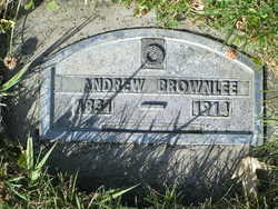
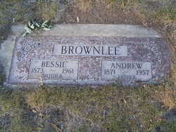
Andrew Brownlee
| Birth | : | 25 Feb 1831 Scotland |
| Death | : | 10 Feb 1914 Pateros, Okanogan County, Washington, USA |
| Burial | : | Price's Corners Cemetery, Prices Corner, Dufferin County, Canada |
| Coordinate | : | 43.8186570, -80.2351690 |
| Description | : | m: Grace Aitchison Washington Death Certificate Name: Andrew Brownlee Death Date: 10 Feb 1914 Death Place: Pateros, Okanogan, Washington Gender: Male Race (Displayed on Form): Age at Death: 82 years 11 months 16 days Estimated Birth Year: 1832 Film Number: 1992189 Digital GS Number: 4220916 Image Number: 1537 Volume/Page/Certificate Number: 9 |
frequently asked questions (FAQ):
-
Where is Andrew Brownlee's memorial?
Andrew Brownlee's memorial is located at: Price's Corners Cemetery, Prices Corner, Dufferin County, Canada.
-
When did Andrew Brownlee death?
Andrew Brownlee death on 10 Feb 1914 in Pateros, Okanogan County, Washington, USA
-
Where are the coordinates of the Andrew Brownlee's memorial?
Latitude: 43.8186570
Longitude: -80.2351690
Family Members:
Children
Flowers:
Nearby Cemetories:
1. Price's Corners Cemetery
Prices Corner, Dufferin County, Canada
Coordinate: 43.8186570, -80.2351690
2. Bethel Presbyterian
East Garafraxa, Dufferin County, Canada
Coordinate: 43.8192000, -80.2348000
3. The Grove Cemetery
East Garafraxa, Dufferin County, Canada
Coordinate: 43.7988100, -80.2092750
4. McKee Cemetery
Craigsholme, Dufferin County, Canada
Coordinate: 43.7811600, -80.2775700
5. Huxley Cemetery
Hillsburgh, Wellington County, Canada
Coordinate: 43.7999660, -80.1600710
6. Mimosa Union Cemetery
Mimosa, Wellington County, Canada
Coordinate: 43.7456690, -80.2202533
7. Waldemar Cemetery
Dufferin County, Canada
Coordinate: 43.8861500, -80.2820000
8. Hillsburgh Pioneer Cemetery
Hillsburgh, Wellington County, Canada
Coordinate: 43.7870610, -80.1400340
9. Saint Peter's Roman Catholic Cemetery
Oustic, Wellington County, Canada
Coordinate: 43.7620750, -80.1530310
10. Mount Carmel Cemetery
Belwood, Wellington County, Canada
Coordinate: 43.7967320, -80.3501690
11. Providence Methodist Cemetery
East Garafraxa, Dufferin County, Canada
Coordinate: 43.8900590, -80.1656360
12. Union Cemetery
Grand Valley, Dufferin County, Canada
Coordinate: 43.8922070, -80.3121550
13. Coningsby Cemetery
Coningsby, Wellington County, Canada
Coordinate: 43.7402000, -80.1196600
14. Greenwood Cemetery
Orangeville, Dufferin County, Canada
Coordinate: 43.9121500, -80.1323500
15. Alton Cemetery
Alton, Peel Regional Municipality, Canada
Coordinate: 43.8581581, -80.0661240
16. South Luther Ebenezer Presbyterian Church Cemetery
East Luther, Dufferin County, Canada
Coordinate: 43.8839870, -80.3883470
17. Church of the Assumption Catholic Cemetery
Erin Township, Wellington County, Canada
Coordinate: 43.7684288, -80.0688324
18. Hughson Family Cemetery
Laurel, Dufferin County, Canada
Coordinate: 43.9281000, -80.1348000
19. Laurel Cemetery
Laurel, Dufferin County, Canada
Coordinate: 43.9579300, -80.2106700
20. McDougall Cemetery
Grand Valley, Dufferin County, Canada
Coordinate: 43.9452210, -80.3261600
21. Erin Cemetery
Erin Township, Wellington County, Canada
Coordinate: 43.7591600, -80.0497800
22. Belsyde Cemetery
Fergus, Wellington County, Canada
Coordinate: 43.7063522, -80.3686829
23. Forest Lawn Cemetery
Orangeville, Dufferin County, Canada
Coordinate: 43.9349430, -80.0981640
24. Saint George's Cemetery
Peel Regional Municipality, Canada
Coordinate: 43.8698226, -80.0325520


