
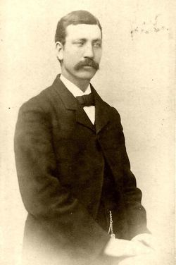
Andrew Jackson “Andy” Dennison
| Birth | : | 11 Aug 1855 Iowa, USA |
| Death | : | 24 Feb 1912 Stevens County, Washington, USA |
| Burial | : | Woodlawn Cemetery, Clinton, Worcester County, USA |
| Coordinate | : | 42.4185982, -71.6889038 |
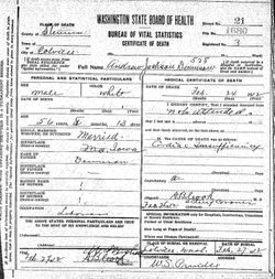
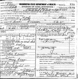
| Description | : | Washington State Digital Archives Online Records DEATH: First Name: Andrew Jackson Last Name: Dennison Date Of Death: 24 Feb 1912 Age: 56 Gender: Male Father Name: Dennison Death Place: Stevens, Washington ~~~...~~~...~~~...~~~ The Colville examiner. (Colville, Wash.), 02 March 1912 Found Dead Andrew J. Dennison, a well known resident of Colville, was found dead where he had been cutting wood last Saturday. He had the ax in his hand, and was lying across the log where he had been at work when he succumbed to heart failure. He was born... Read More |
frequently asked questions (FAQ):
-
Where is Andrew Jackson “Andy” Dennison's memorial?
Andrew Jackson “Andy” Dennison's memorial is located at: Woodlawn Cemetery, Clinton, Worcester County, USA.
-
When did Andrew Jackson “Andy” Dennison death?
Andrew Jackson “Andy” Dennison death on 24 Feb 1912 in Stevens County, Washington, USA
-
Where are the coordinates of the Andrew Jackson “Andy” Dennison's memorial?
Latitude: 42.4185982
Longitude: -71.6889038
Family Members:
Parent

Spouse
Siblings
Children
Flowers:


Nearby Cemetories:
1. Woodlawn Cemetery
Clinton, Worcester County, USA
Coordinate: 42.4185982, -71.6889038
2. Saint John's Cemetery
Lancaster, Worcester County, USA
Coordinate: 42.4328003, -71.6977997
3. Reservoir Pines Cemetery
Clinton, Worcester County, USA
Coordinate: 42.4084900, -71.7109700
4. Old Common Burial Ground
Lancaster, Worcester County, USA
Coordinate: 42.4426700, -71.6645300
5. Fairbank Burial Ground
Sterling, Worcester County, USA
Coordinate: 42.4152600, -71.7320000
6. Middle Cemetery
Lancaster, Worcester County, USA
Coordinate: 42.4491997, -71.6757965
7. Old Settlers Burial Yard
Lancaster, Worcester County, USA
Coordinate: 42.4488754, -71.6742706
8. Eastwood Cemetery
Lancaster, Worcester County, USA
Coordinate: 42.4417000, -71.6528015
9. Thayer Cemetery
Lancaster, Worcester County, USA
Coordinate: 42.4578500, -71.7024400
10. Hillside Cemetery
Sterling, Worcester County, USA
Coordinate: 42.4410000, -71.7492570
11. Oak Hill Cemetery
Sterling, Worcester County, USA
Coordinate: 42.4417000, -71.7493973
12. North Cemetery
Berlin, Worcester County, USA
Coordinate: 42.4037000, -71.6225100
13. Old Fry Burying Ground
Bolton, Worcester County, USA
Coordinate: 42.4077300, -71.6209900
14. Chocksett Burial Ground
Sterling, Worcester County, USA
Coordinate: 42.4377000, -71.7555400
15. Friends Burial Ground
Bolton, Worcester County, USA
Coordinate: 42.4133620, -71.6176710
16. West Burying Ground
Bolton, Worcester County, USA
Coordinate: 42.4488983, -71.6300964
17. Old Burying Ground
Berlin, Worcester County, USA
Coordinate: 42.3811646, -71.6375351
18. North Village Cemetery
Lancaster, Worcester County, USA
Coordinate: 42.4724998, -71.6778030
19. Old South Burying Ground
Bolton, Worcester County, USA
Coordinate: 42.4231000, -71.6096500
20. Saint Lukes Cemetery
West Boylston, Worcester County, USA
Coordinate: 42.3833008, -71.7568970
21. Cookshire Cemetery
Sterling, Worcester County, USA
Coordinate: 42.4108500, -71.7734800
22. West Cemetery
Sterling, Worcester County, USA
Coordinate: 42.4514100, -71.7651400
23. South Berlin Cemetery
Berlin, Worcester County, USA
Coordinate: 42.3652992, -71.6292038
24. Pine Grove Cemetery
Boylston, Worcester County, USA
Coordinate: 42.3582993, -71.7431030