
| Birth | : | 30 Oct 1870 Indiana, USA |
| Death | : | 12 Oct 1955 Pottawattamie County, Iowa, USA |
| Burial | : | Great Harwood Cemetery, Great Harwood, Hyndburn Borough, England |
| Coordinate | : | 53.7796190, -2.4091680 |
| Plot | : | Section-Acacia, Lot 101 |
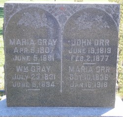
| Description | : | Andrew T. Orr was the 6th child of John Orr & Maria Gray. Brother of William Robert, Elizabeth, John L., Mary,Catherine Grace, Henry, & Richard C. Orr. On January 01, 1905 he married Minnie Annie Abrens. They had 10 Children; Leo Earl, Margherita, Thelma Loraine, Harvey Halley, Percy D., Naomi Eileen, John Lewis, Milton Manley, Ervin LeRoy, & Gilbert Lawrence Orr |
frequently asked questions (FAQ):
-
Where is Andrew Tecumseh Orr's memorial?
Andrew Tecumseh Orr's memorial is located at: Great Harwood Cemetery, Great Harwood, Hyndburn Borough, England.
-
When did Andrew Tecumseh Orr death?
Andrew Tecumseh Orr death on 12 Oct 1955 in Pottawattamie County, Iowa, USA
-
Where are the coordinates of the Andrew Tecumseh Orr's memorial?
Latitude: 53.7796190
Longitude: -2.4091680
Family Members:
Parent
Spouse

Siblings
Children
Flowers:


Nearby Cemetories:
1. Great Harwood Cemetery
Great Harwood, Hyndburn Borough, England
Coordinate: 53.7796190, -2.4091680
2. Our Lady and Saint Hubert
Great Harwood, Hyndburn Borough, England
Coordinate: 53.7851070, -2.4009760
3. St. Bartholomew's Churchyard
Great Harwood, Hyndburn Borough, England
Coordinate: 53.7900670, -2.4055460
4. All Saints Churchyard
Clayton-le-Moors, Hyndburn Borough, England
Coordinate: 53.7738520, -2.3881690
5. Barnes Square Weslyan Methodist Churchyard
Clayton-le-Moors, Hyndburn Borough, England
Coordinate: 53.7744350, -2.3853800
6. St Marys Burial Ground
Clayton-le-Moors, Hyndburn Borough, England
Coordinate: 53.7792778, -2.3705871
7. Church and Clayton-le-Moors Cemetery
Accrington, Hyndburn Borough, England
Coordinate: 53.7630200, -2.3804820
8. St James Churchyard
Church, Hyndburn Borough, England
Coordinate: 53.7574640, -2.3942660
9. St. James' Parish Church
Accrington, Hyndburn Borough, England
Coordinate: 53.7519900, -2.3652600
10. Accrington Cemetery and Crematorium
Accrington, Hyndburn Borough, England
Coordinate: 53.7623787, -2.3508649
11. St James Church
Altham, Hyndburn Borough, England
Coordinate: 53.7928940, -2.3465250
12. Blackburn Cemetery
Blackburn, Blackburn with Darwen Unitary Authority, England
Coordinate: 53.7662430, -2.4726050
13. Saint Mary and All Saints Churchyard
Whalley, Ribble Valley Borough, England
Coordinate: 53.8211890, -2.4078080
14. New Lane Baptist Chapel Chapelyard
Oswaldwistle, Hyndburn Borough, England
Coordinate: 53.7381100, -2.4049500
15. St. John's Churchyard
Read, Ribble Valley Borough, England
Coordinate: 53.8088800, -2.3585600
16. Christ Church Churchyard
Accrington, Hyndburn Borough, England
Coordinate: 53.7478560, -2.3605820
17. Immanuel Churchyard
Oswaldwistle, Hyndburn Borough, England
Coordinate: 53.7358300, -2.4056200
18. St Peter Churchyard
Salesbury, Ribble Valley Borough, England
Coordinate: 53.7915000, -2.4859100
19. St. Leonard Old Churchyard
Langho, Ribble Valley Borough, England
Coordinate: 53.8178590, -2.4552870
20. St Alban's Churchyard
Blackburn, Blackburn with Darwen Unitary Authority, England
Coordinate: 53.7530090, -2.4748540
21. Brockhall Hospital Cemetery
Brockhall Village, Ribble Valley Borough, England
Coordinate: 53.8186850, -2.4560220
22. Holy Trinity Church
Blackburn with Darwen Unitary Authority, England
Coordinate: 53.7511727, -2.4747178
23. Whalley, Wiswell and Barrow Cemetery
Whalley, Ribble Valley Borough, England
Coordinate: 53.8308490, -2.4057280
24. Mount St Presbyterian Chapelyard
Blackburn, Blackburn with Darwen Unitary Authority, England
Coordinate: 53.7478000, -2.4775000