
Ann Carter Wolf
| Birth | : | 30 Jun 1761 New Jersey, USA |
| Death | : | 27 Dec 1835 Fayette County, Indiana, USA |
| Burial | : | Camellia Memorial Lawn Cemetery, Sacramento, Sacramento County, USA |
| Coordinate | : | 38.5242004, -121.3097000 |
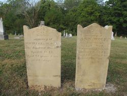
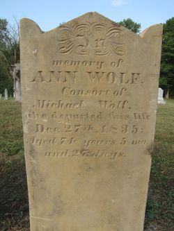
| Description | : | Ann is buried next to her husband Michael Wolf. Her gravemarker reads died 27 DEC 1835, wife of Michael- aged 74Y 5M 27D. SOURCE: USGENWEB for Union County IN. |
frequently asked questions (FAQ):
-
Where is Ann Carter Wolf's memorial?
Ann Carter Wolf's memorial is located at: Camellia Memorial Lawn Cemetery, Sacramento, Sacramento County, USA.
-
When did Ann Carter Wolf death?
Ann Carter Wolf death on 27 Dec 1835 in Fayette County, Indiana, USA
-
Where are the coordinates of the Ann Carter Wolf's memorial?
Latitude: 38.5242004
Longitude: -121.3097000
Family Members:
Spouse

Children


Nearby Cemetories:
1. Camellia Memorial Lawn Cemetery
Sacramento, Sacramento County, USA
Coordinate: 38.5242004, -121.3097000
2. Bellview Cemetery
Sacramento, Sacramento County, USA
Coordinate: 38.5153580, -121.3257446
3. Quiet Haven Memorial Park Cemetery
Sacramento, Sacramento County, USA
Coordinate: 38.5109711, -121.3245621
4. Greater Sacramento Muslim Cemetery
Sacramento, Sacramento County, USA
Coordinate: 38.5128300, -121.2616800
5. Sacramento Pet Cemetery
Sacramento, Sacramento County, USA
Coordinate: 38.4815870, -121.3402080
6. Chua Phuoc Thien Temple Columbarium
Sacramento, Sacramento County, USA
Coordinate: 38.4555400, -121.3345500
7. Kilgore Cemetery
Rancho Cordova, Sacramento County, USA
Coordinate: 38.5978012, -121.2683029
8. Tinh Xa Ngoc An Temple Columbarium
Sacramento, Sacramento County, USA
Coordinate: 38.5190200, -121.4159500
9. Elder Creek Cemetery
Florin, Sacramento County, USA
Coordinate: 38.5111008, -121.4169006
10. Union Cemetery
Sacramento County, USA
Coordinate: 38.4477997, -121.2619019
11. Saint Michaels Episcopal Church Columbarium
Carmichael, Sacramento County, USA
Coordinate: 38.6042800, -121.3547200
12. Sacramento County Cemetery
Sacramento County, USA
Coordinate: 38.5267900, -121.4233700
13. Sacramento County Veterans Memorial Cemetery
Sacramento, Sacramento County, USA
Coordinate: 38.5252838, -121.4239120
14. Sacramento County Hospital Cemetery
Sacramento, Sacramento County, USA
Coordinate: 38.5289300, -121.4239100
15. Russian Orthodox Cemetery
Sacramento, Sacramento County, USA
Coordinate: 38.5268800, -121.4244300
16. Saint Mary's Catholic Cemetery and Mausoleum
Sacramento, Sacramento County, USA
Coordinate: 38.5298900, -121.4261200
17. Pleasant Grove Cemetery
Elk Grove, Sacramento County, USA
Coordinate: 38.4302220, -121.3107670
18. Carmichael Presbyterian Church Columbarium
Carmichael, Sacramento County, USA
Coordinate: 38.6179500, -121.3324500
19. Sloughhouse Pioneer Cemetery
Sloughhouse, Sacramento County, USA
Coordinate: 38.4950130, -121.1916080
20. Saint Marks Methodist Church Memorial Tree
Sacramento, Sacramento County, USA
Coordinate: 38.6076500, -121.3750680
21. Kim Quang Temple Columbarium
Sacramento, Sacramento County, USA
Coordinate: 38.5996600, -121.3904700
22. Sacramento Memorial Lawn Cemetery
Sacramento, Sacramento County, USA
Coordinate: 38.5146484, -121.4380341
23. Home of Peace Cemetery
Sacramento, Sacramento County, USA
Coordinate: 38.5137558, -121.4382782
24. San Joaquin Cemetery
Sacramento, Sacramento County, USA
Coordinate: 38.4387665, -121.4034653