

Michael C Wolf Sr.
| Birth | : | 19 Dec 1761 Monmouth County, New Jersey, USA |
| Death | : | 11 Apr 1843 Fayette County, Indiana, USA |
| Burial | : | St. Mary's Churchyard, Haddiscoe, South Norfolk District, England |
| Coordinate | : | 52.5153200, 1.5939300 |
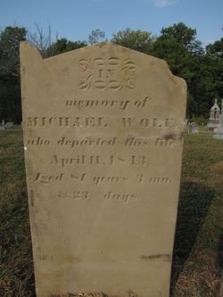
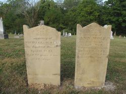
| Description | : | Michael Wolf probably came from New Jersey to Butler Co., OH, and from there to Fayette Co., IN where he died. His will was probated in Fayette Co. Court on 1 June 1843, executors were Elihu "Crandall" and his son Michael Wolf, Jr. His will names children: Michael Wolf, David Wolf, Margaret (wife of Elihu) Crandel (of Fayette Co., IN, Juda Winterode (Judith wife of David Winterrowd), Elizabeth (wife of John) McGinnis, and Keziah (wife of Benjamin Frederick) Dobson. Michael is buried next to his wife Ann. His gravemarker reads: died 11 April 1843 Aged 81Y 3M 23D. Source: USGENWEB... Read More |
frequently asked questions (FAQ):
-
Where is Michael C Wolf Sr.'s memorial?
Michael C Wolf Sr.'s memorial is located at: St. Mary's Churchyard, Haddiscoe, South Norfolk District, England.
-
When did Michael C Wolf Sr. death?
Michael C Wolf Sr. death on 11 Apr 1843 in Fayette County, Indiana, USA
-
Where are the coordinates of the Michael C Wolf Sr.'s memorial?
Latitude: 52.5153200
Longitude: 1.5939300
Family Members:
Spouse
Children


Nearby Cemetories:
1. St. Mary's Churchyard
Haddiscoe, South Norfolk District, England
Coordinate: 52.5153200, 1.5939300
2. Thorpe-next-Haddiscoe St Mathias Churchyard
Haddiscoe, South Norfolk District, England
Coordinate: 52.5261880, 1.5896380
3. Methodist Churchyard
Norton Subcourse, North Norfolk District, England
Coordinate: 52.5317630, 1.5557020
4. St Olave's Priory
Herringfleet, Waveney District, England
Coordinate: 52.5381200, 1.6240290
5. Ss Mary and Margaret Churchyard
Norton Subcourse, North Norfolk District, England
Coordinate: 52.5324780, 1.5483860
6. St Mary the Virgin Churchyard
Aldeby, South Norfolk District, England
Coordinate: 52.4826360, 1.6075660
7. St Margaret's Churchyard
Herringfleet, Waveney District, England
Coordinate: 52.5218820, 1.6493630
8. St Andrews Churchyard
Raveningham, South Norfolk District, England
Coordinate: 52.5126430, 1.5323570
9. St Edmund's Churchyard
Fritton, Great Yarmouth Borough, England
Coordinate: 52.5430920, 1.6460460
10. St Mary Churchyard
Somerleyton, Waveney District, England
Coordinate: 52.5157800, 1.6730900
11. St Mary's Churchyard
Gillingham, South Norfolk District, England
Coordinate: 52.4750343, 1.5489500
12. All Saints Churchyard
Gillingham, South Norfolk District, England
Coordinate: 52.4753720, 1.5479546
13. St Mary's Parish Churchyard
Ashby, Waveney District, England
Coordinate: 52.5322480, 1.6693690
14. St Margaret Churchyard
Hales, South Norfolk District, England
Coordinate: 52.5109380, 1.5110840
15. St John the Baptist Churchyard
Reedham, Broadland District, England
Coordinate: 52.5660500, 1.5807900
16. St Gregory Churchyard
Heckingham, South Norfolk District, England
Coordinate: 52.5350940, 1.5144710
17. St Mary's Churchyard
Burgh St Peter, South Norfolk District, England
Coordinate: 52.4840860, 1.6710830
18. St Michael Churchyard
Geldeston, South Norfolk District, England
Coordinate: 52.4759460, 1.5246070
19. St Margaret's Churchyard
Hardley Street, South Norfolk District, England
Coordinate: 52.5522980, 1.5170630
20. St. Michael's Churchyard
Beccles, Waveney District, England
Coordinate: 52.4585640, 1.5621960
21. St John the Baptist Churchyard
Lound, Waveney District, England
Coordinate: 52.5310680, 1.6937750
22. All Saints Churchyard
Worlingham, Waveney District, England
Coordinate: 52.4517300, 1.5969000
23. Kilbrack Cemetery
Beccles, Waveney District, England
Coordinate: 52.4535653, 1.5686063
24. All Saints Churchyard
Kirby Cane, South Norfolk District, England
Coordinate: 52.4937500, 1.4952820