

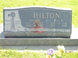
Anna Louise Rickertsen Hilton
| Birth | : | 4 Oct 1911 Lexington, Dawson County, Nebraska, USA |
| Death | : | 16 Jul 2010 Elwood, Gosper County, Nebraska, USA |
| Burial | : | St. Helen’s & All Saints Churchyard, Wykeham, Scarborough Borough, England |
| Coordinate | : | 54.2372000, -0.5212000 |
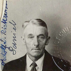
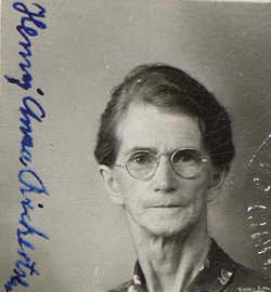
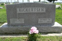
| Description | : | Anna Hilton, 98, died Friday, July 16, 2010, at the Elwood Care Center. Anna was born Oct. 4, 1911, in Lexington to Adolph and Henny (Seehusen) Rickertsen. She attended Lexington High School where she graduated in 1929. On Feb. 25, 1934, she married Roy Hilton in Lexington. To this union six children were born. The couple farmed in the rural Lexington and Cozad areas until 1955, when they moved to Elwood. While in Elwood, they owned and operated the Corner Café and Creamery until 1962. It was at this point that the couple began work with the Elwood Public School... Read More |
frequently asked questions (FAQ):
-
Where is Anna Louise Rickertsen Hilton's memorial?
Anna Louise Rickertsen Hilton's memorial is located at: St. Helen’s & All Saints Churchyard, Wykeham, Scarborough Borough, England.
-
When did Anna Louise Rickertsen Hilton death?
Anna Louise Rickertsen Hilton death on 16 Jul 2010 in Elwood, Gosper County, Nebraska, USA
-
Where are the coordinates of the Anna Louise Rickertsen Hilton's memorial?
Latitude: 54.2372000
Longitude: -0.5212000
Family Members:
Parent
Spouse
Siblings


Children
Flowers:


Nearby Cemetories:
1. St. Helen’s & All Saints Churchyard
Wykeham, Scarborough Borough, England
Coordinate: 54.2372000, -0.5212000
2. St Matthew Churchyard
Hutton Buscel, Scarborough Borough, England
Coordinate: 54.2426410, -0.5071200
3. All Saints Church Cemetery
Brompton-by-Sawdon, Scarborough Borough, England
Coordinate: 54.2223100, -0.5500900
4. All Saints Churchyard
Brompton-by-Sawdon, Scarborough Borough, England
Coordinate: 54.2262550, -0.5549320
5. St. John the Baptist Churchyard
East Ayton, Scarborough Borough, England
Coordinate: 54.2508900, -0.4792900
6. St Stephen Churchyard
Snainton, Scarborough Borough, England
Coordinate: 54.2286490, -0.5913720
7. St Martin Churchyard
Seamer, Scarborough Borough, England
Coordinate: 54.2361500, -0.4437100
8. St. Hilda Churchyard
Sherburn, Ryedale District, England
Coordinate: 54.1837400, -0.5311200
9. St. Peter's Churchyard
Willerby, Ryedale District, England
Coordinate: 54.1984200, -0.4558500
10. St Nicholas Churchyard
Ganton, Ryedale District, England
Coordinate: 54.1846000, -0.4846000
11. Woodlands Cemetery and Crematorium
Scarborough, Scarborough Borough, England
Coordinate: 54.2766640, -0.4428030
12. St Peter Churchyard
Hackness, Scarborough Borough, England
Coordinate: 54.3012880, -0.5127850
13. St. Mary the Virgin Churchyard
Ebberston, Ryedale District, England
Coordinate: 54.2375130, -0.6330510
14. St. Andrew's Churchyard
East Heslerton, Ryedale District, England
Coordinate: 54.1772500, -0.5825000
15. St Peter Churchyard
Langdale End, Scarborough Borough, England
Coordinate: 54.3065050, -0.5557030
16. St. John the Baptist Churchyard
Yedingham, Ryedale District, England
Coordinate: 54.2041744, -0.6320491
17. St Laurence Churchyard
Scalby, Scarborough Borough, England
Coordinate: 54.2988160, -0.4507520
18. Dean Road and Manor Road Cemetery
Scarborough, Scarborough Borough, England
Coordinate: 54.2843690, -0.4184140
19. St John Churchyard
Allerston, Ryedale District, England
Coordinate: 54.2342700, -0.6542290
20. St. John the Baptist Churchyard
Cayton, Scarborough Borough, England
Coordinate: 54.2346470, -0.3805180
21. All Saints Churchyard
West Heslerton, Ryedale District, England
Coordinate: 54.1704100, -0.6057100
22. Flixton Cemetery New
Folkton, Scarborough Borough, England
Coordinate: 54.2006600, -0.3934700
23. Cayton Cemetery
Cayton, Scarborough Borough, England
Coordinate: 54.2314030, -0.3755910
24. St John The Evangelist Churchyard
Folkton, Scarborough Borough, England
Coordinate: 54.2020400, -0.3865200