
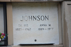
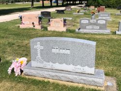
Anna Maria Tell Johnson
| Birth | : | 26 Dec 1889 Greenview, Menard County, Illinois, USA |
| Death | : | 20 Apr 1977 Rochester, Olmsted County, Minnesota, USA |
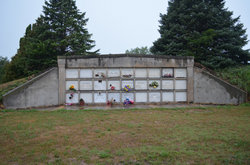
| Burial | : | Dayton Cemetery, Dayton, Webster County, USA |
| Coordinate | : | 42.2675000, -94.0755000 |
| Description | : | The funeral service was held at the United Methodist Church in Dayton, Iowa on Saturday, April 23, 1977 at 1:30 p.m and Conducted by the Reverend William Cotton. Special Organ Music provided by Monte Iles. Caring for the Flowers were Roberta McIlvain and Dorothy Stark Casketbearers were Gerald Tell Robert Tell Keith Tell Wayne Tell Dick Tell Roy Heggen Graveside services were conducted by the Acorn Chapter #504 of the Order of the Eastern Star. Handwritten on the card is "Bernadine's Mother". ~ Information from a Memorial Service Card in the scrapbook of Helen Ray ----------------- Suggestions... Read More |
frequently asked questions (FAQ):
-
Where is Anna Maria Tell Johnson's memorial?
Anna Maria Tell Johnson's memorial is located at: Dayton Cemetery, Dayton, Webster County, USA.
-
When did Anna Maria Tell Johnson death?
Anna Maria Tell Johnson death on 20 Apr 1977 in Rochester, Olmsted County, Minnesota, USA
-
Where are the coordinates of the Anna Maria Tell Johnson's memorial?
Latitude: 42.2675000
Longitude: -94.0755000
Family Members:
Parent

Spouse

Siblings
Children
Flowers:


Nearby Cemetories:
1. Dayton Cemetery
Dayton, Webster County, USA
Coordinate: 42.2675000, -94.0755000
2. Christ the King Catholic Cemetery
Dayton, Webster County, USA
Coordinate: 42.2601929, -94.0727539
3. Bass Cemetery
Dayton, Webster County, USA
Coordinate: 42.2966995, -94.0149994
4. Swedish Lutheran Church Cemetery
Dayton, Webster County, USA
Coordinate: 42.2175000, -94.1065000
5. Oak Grove Cemetery
Lehigh, Webster County, USA
Coordinate: 42.3438988, -94.0475006
6. Hardin Township Cemetery
Hardin Township, Webster County, USA
Coordinate: 42.2411003, -93.9708023
7. Linn Cemetery
Pilot Mound, Boone County, USA
Coordinate: 42.2045330, -93.9970230
8. Lawn Cemetery
Boone County, USA
Coordinate: 42.1771011, -94.0867996
9. West Lawn Cemetery
Lehigh, Webster County, USA
Coordinate: 42.3616982, -94.0678024
10. McGuire Bend Cemetery
Dayton, Webster County, USA
Coordinate: 42.3410000, -93.9880000
11. Runyan Cemetery
Pilot Mound, Boone County, USA
Coordinate: 42.1749992, -94.0015030
12. Pilot Mound Cemetery
Pilot Mound, Boone County, USA
Coordinate: 42.1636200, -94.0282600
13. Vegors Cemetery
Webster County, USA
Coordinate: 42.3177986, -93.9421997
14. Lost Grove Cemetery
Harcourt, Webster County, USA
Coordinate: 42.2583008, -94.2331009
15. Hooks Point Cemetery
Hamilton County, USA
Coordinate: 42.2944530, -93.9199090
16. Oakwood Cemetery
Stratford, Hamilton County, USA
Coordinate: 42.2942009, -93.9182968
17. Hartman Cemetery
Lehigh, Webster County, USA
Coordinate: 42.3666397, -93.9835627
18. White Cemetery
Boone County, USA
Coordinate: 42.1777992, -93.9636002
19. Border Plains Cemetery
Border Plains, Webster County, USA
Coordinate: 42.3917000, -94.0448000
20. Ober and Scott Cemetery
Duncombe, Webster County, USA
Coordinate: 42.3841390, -93.9982856
21. Union Cemetery
Boxholm, Boone County, USA
Coordinate: 42.1369019, -94.0852966
22. Renner Cemetery
Boone County, USA
Coordinate: 42.1380420, -94.1256570
23. Otho Cemetery
Otho, Webster County, USA
Coordinate: 42.4025002, -94.1153030
24. Schlicht Cemetery
Fraser, Boone County, USA
Coordinate: 42.1444200, -93.9780100