
| Birth | : | 23 Nov 1898 Akron, Plymouth County, Iowa, USA |
| Death | : | 17 Mar 1949 Hawarden, Sioux County, Iowa, USA |
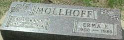
| Burial | : | Riverside Cemetery, Akron, Plymouth County, USA |
| Coordinate | : | 42.8367004, -96.5453033 |
| Description | : | Sustained Fatal Burns In Gas Explosion Accident Feb. 22 Miss Anna Mollhoff, a niece of Mrs. anna Degen, of this city, passed away at the Hawarden Hospital last Thursday morning, March 17, 1949. She was the victim of an unusual accident when she suffered severe burns about her body by the explosion of gas which had seeped into the basement of her home in Hawarden from the outside on February 22. She was rushed to the hospital there for treatment and care and for a time there appeared to be hope for her recovery; but... Read More |
frequently asked questions (FAQ):
-
Where is Anna Marie Mollhoff's memorial?
Anna Marie Mollhoff's memorial is located at: Riverside Cemetery, Akron, Plymouth County, USA.
-
When did Anna Marie Mollhoff death?
Anna Marie Mollhoff death on 17 Mar 1949 in Hawarden, Sioux County, Iowa, USA
-
Where are the coordinates of the Anna Marie Mollhoff's memorial?
Latitude: 42.8367004
Longitude: -96.5453033
Family Members:
Parent

Siblings
Flowers:


Nearby Cemetories:
1. Riverside Cemetery
Akron, Plymouth County, USA
Coordinate: 42.8367004, -96.5453033
2. Saint Patricks Cemetery
Akron, Plymouth County, USA
Coordinate: 42.8232300, -96.5374800
3. Mount Hope Cemetery
Union County, USA
Coordinate: 42.8885994, -96.5667038
4. Union Creek Cemetery
Union County, USA
Coordinate: 42.8911018, -96.5863037
5. Gores Bluff Cemetery
Union County, USA
Coordinate: 42.8035069, -96.6260468
6. Westfield Township Cemetery
Westfield, Plymouth County, USA
Coordinate: 42.7510986, -96.5914001
7. Richland Cemetery
Richland, Union County, USA
Coordinate: 42.7682991, -96.6624985
8. Pleasant Hill Cemetery
Spink, Union County, USA
Coordinate: 42.8741000, -96.6876000
9. Big Springs Cemetery
Big Springs, Union County, USA
Coordinate: 42.9379000, -96.6090000
10. Old Big Springs Cemetery
Big Springs, Union County, USA
Coordinate: 42.9455986, -96.5868988
11. Saint Johns Lutheran Church Cemetery
Ruble, Plymouth County, USA
Coordinate: 42.8372000, -96.3799000
12. Mills Family Cemetery
Westfield, Plymouth County, USA
Coordinate: 42.7188460, -96.6019280
13. First Brule Creek Cemetery
Elk Point, Union County, USA
Coordinate: 42.7943993, -96.7069016
14. Pleasant Hill Cemetery Old
Spink, Union County, USA
Coordinate: 42.8588462, -96.7215592
15. Brule Creek Cemetery
Spink Township, Union County, USA
Coordinate: 42.8346510, -96.7324350
16. Pleasant Valley Cemetery
Adaville, Plymouth County, USA
Coordinate: 42.7494011, -96.4005966
17. Saint Paul Cemetery
Elk Point, Union County, USA
Coordinate: 42.7641983, -96.7061005
18. Union County Poor Farm Cemetery
Union County, USA
Coordinate: 42.7649210, -96.7077580
19. Nora Cemetery
Union County, USA
Coordinate: 42.9314003, -96.7061005
20. Plymouth Presbyterian Cemetery
Brunsville, Plymouth County, USA
Coordinate: 42.8208760, -96.3318410
21. Ahlsborg Lutheran Cemetery
Union County, USA
Coordinate: 42.8228000, -96.7612000
22. Saint Joseph Cemetery
Johnson Township, Plymouth County, USA
Coordinate: 42.7416992, -96.3707962
23. Peace Lutheran Cemetery
Union County, USA
Coordinate: 42.9805984, -96.6481018
24. Saint Johns Cemetery
Craig, Plymouth County, USA
Coordinate: 42.8939018, -96.3225021