
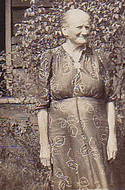
| Birth | : | 9 Nov 1872 Clay County, Tennessee, USA |
| Death | : | 8 Mar 1941 Clay County, Tennessee, USA |
| Burial | : | St Chad Church Extension, Dunholme, West Lindsey District, England |
| Coordinate | : | 53.3008900, -0.4621500 |
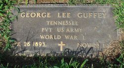
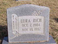
| Description | : | Children: George Lee Guffey 1893 – 1972 Eva Lena Guffey 1896 – 1967 Ollie Mae Guffey 1898 – 1984 Ader Guffey 1902 – Lura Guffey 1904 – |
frequently asked questions (FAQ):
-
Where is Anna R “Annie” Reecer Guffey's memorial?
Anna R “Annie” Reecer Guffey's memorial is located at: St Chad Church Extension, Dunholme, West Lindsey District, England.
-
When did Anna R “Annie” Reecer Guffey death?
Anna R “Annie” Reecer Guffey death on 8 Mar 1941 in Clay County, Tennessee, USA
-
Where are the coordinates of the Anna R “Annie” Reecer Guffey's memorial?
Latitude: 53.3008900
Longitude: -0.4621500
Family Members:
Parent

Spouse
Siblings
Children
Flowers:


Nearby Cemetories:
1. St Chad Church Extension
Dunholme, West Lindsey District, England
Coordinate: 53.3008900, -0.4621500
2. St. Chad Churchyard
Dunholme, West Lindsey District, England
Coordinate: 53.3018330, -0.4638100
3. St. Germain Churchyard
Scothern, West Lindsey District, England
Coordinate: 53.2835790, -0.4513370
4. Scothern Cemetery
Scothern, West Lindsey District, England
Coordinate: 53.2798200, -0.4515500
5. St. Edward the Confessor Churchyard
Sudbrooke, West Lindsey District, England
Coordinate: 53.2717840, -0.4553930
6. St. Lawrence Churchyard
Snarford, West Lindsey District, England
Coordinate: 53.3283300, -0.4239900
7. St. John the Baptist Churchyard
Langworth, West Lindsey District, England
Coordinate: 53.2843900, -0.4086800
8. All Saints Churchyard
Cold Hanworth, West Lindsey District, England
Coordinate: 53.3357700, -0.4471700
9. All Saints Churchyard
Nettleham, West Lindsey District, England
Coordinate: 53.2652940, -0.4906780
10. Nettleham Cemetery
Nettleham, West Lindsey District, England
Coordinate: 53.2645600, -0.4904000
11. St Michael Churchyard
Hackthorn, West Lindsey District, England
Coordinate: 53.3288810, -0.5134350
12. Barlings Cemetery
Langworth, West Lindsey District, England
Coordinate: 53.2728290, -0.4041870
13. All Saints Churchyard
Snelland, West Lindsey District, England
Coordinate: 53.3120800, -0.3812000
14. St. Mary's Churchyard
Riseholme, West Lindsey District, England
Coordinate: 53.2688200, -0.5264900
15. St. Peter and St. Paul Churchyard
Reepham, West Lindsey District, England
Coordinate: 53.2518050, -0.4450120
16. Dam Busters Dog Memorial
Scampton, West Lindsey District, England
Coordinate: 53.3008200, -0.5495800
17. Hawthorn Road Cemetery
Reepham, West Lindsey District, England
Coordinate: 53.2489252, -0.4513445
18. St. Peter's Churchyard
Friesthorpe, West Lindsey District, England
Coordinate: 53.3367420, -0.3915860
19. St. Edward's Churchyard
Barlings, West Lindsey District, England
Coordinate: 53.2600000, -0.3890000
20. All Saints Churchyard
Faldingworth, West Lindsey District, England
Coordinate: 53.3490800, -0.3995900
21. St. Peter & St. Paul Churchyard
Cherry Willingham, West Lindsey District, England
Coordinate: 53.2387000, -0.4553800
22. St. Helen's Churchyard
Saxby, West Lindsey District, England
Coordinate: 53.3625100, -0.4920400
23. St. Clement's Churchyard
Fiskerton, West Lindsey District, England
Coordinate: 53.2345500, -0.4315200
24. St. John the Baptist Churchyard
Scampton, West Lindsey District, England
Coordinate: 53.3037680, -0.5787140