
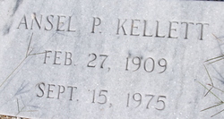
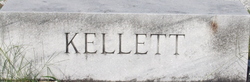
Ansel P Kellett
| Birth | : | 27 Feb 1909 |
| Death | : | 15 Sep 1975 |
| Burial | : | Christ Church Totland Bay, Totland, Isle of Wight Unitary Authority, England |
| Coordinate | : | 50.6760770, -1.5448160 |
frequently asked questions (FAQ):
-
Where is Ansel P Kellett's memorial?
Ansel P Kellett's memorial is located at: Christ Church Totland Bay, Totland, Isle of Wight Unitary Authority, England.
-
When did Ansel P Kellett death?
Ansel P Kellett death on 15 Sep 1975 in
-
Where are the coordinates of the Ansel P Kellett's memorial?
Latitude: 50.6760770
Longitude: -1.5448160
Family Members:
Parent

Spouse
Siblings
Children
Flowers:


Nearby Cemetories:
1. Christ Church Totland Bay
Totland, Isle of Wight Unitary Authority, England
Coordinate: 50.6760770, -1.5448160
2. St Saviour Roman Catholic Churchyard
Totland, Isle of Wight Unitary Authority, England
Coordinate: 50.6762700, -1.5410390
3. St Agnes Churchyard
Freshwater, Isle of Wight Unitary Authority, England
Coordinate: 50.6731050, -1.5173550
4. All Saints Churchyard
Freshwater, Isle of Wight Unitary Authority, England
Coordinate: 50.6843570, -1.5102280
5. St James Churchyard
Yarmouth, Isle of Wight Unitary Authority, England
Coordinate: 50.7055370, -1.4991890
6. St. Swithin's Old Churchyard
Thorley, Isle of Wight Unitary Authority, England
Coordinate: 50.7007450, -1.4815300
7. All Saints Churchyard
Milford-on-Sea, New Forest District, England
Coordinate: 50.7278170, -1.5897770
8. St. Mary the Virgin Churchyard
Brook, Isle of Wight Unitary Authority, England
Coordinate: 50.6577970, -1.4430340
9. St Peter and St Paul’s Churchyard
Mottistone, Isle of Wight Unitary Authority, England
Coordinate: 50.6517620, -1.4275530
10. St. Mark's Churchyard
Pennington, New Forest District, England
Coordinate: 50.7545700, -1.5631100
11. St. Thomas the Apostle Churchyard
Lymington, New Forest District, England
Coordinate: 50.7576410, -1.5451200
12. Lymington Cemetery
Lymington, New Forest District, England
Coordinate: 50.7576200, -1.5576200
13. St. Michael the Archangel Churchyard
Shalfleet, Isle of Wight Unitary Authority, England
Coordinate: 50.7014300, -1.4156370
14. All Saints Churchyard
Hordle, New Forest District, England
Coordinate: 50.7549400, -1.6136200
15. All Saints Churchyard
Calbourne, Isle of Wight Unitary Authority, England
Coordinate: 50.6772990, -1.3996370
16. Ashley Baptist Cemetery
New Milton, New Forest District, England
Coordinate: 50.7529200, -1.6336400
17. St Mary Churchyard
South Baddesley, New Forest District, England
Coordinate: 50.7691430, -1.5026160
18. Holy Spirit Churchyard
Newtown, Isle of Wight Unitary Authority, England
Coordinate: 50.7143690, -1.4035400
19. Milford Road Cemetery
New Milton, New Forest District, England
Coordinate: 50.7472700, -1.6502700
20. Calbourne Burial Ground
Calbourne, Isle of Wight Unitary Authority, England
Coordinate: 50.6832007, -1.3864018
21. St. Mary the Virgin Churchyard
Brighstone, Isle of Wight Unitary Authority, England
Coordinate: 50.6422540, -1.3944850
22. St Mary Magdalene Churchyard
New Milton, New Forest District, England
Coordinate: 50.7481200, -1.6645700
23. New Milton Cemetery
New Milton, New Forest District, England
Coordinate: 50.7507690, -1.6650340
24. St Luke Churchyard
Sway, New Forest District, England
Coordinate: 50.7839000, -1.6058800