Anthony Vogel Fogle
| Birth | : | 1745 Virginia, USA |
| Death | : | 16 Feb 1816 Saint Matthews, Calhoun County, South Carolina, USA |
| Burial | : | Barnston Cemetery, Barnston, Metropolitan Borough of Wirral, England |
| Coordinate | : | 53.3408590, -3.0820730 |
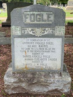
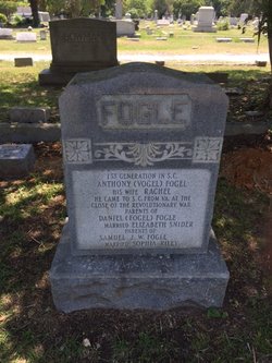
| Inscription | : | 1st GENERATION IN S.C. ANTHONY (VOGEL)FOGEL HIS WIFE RACHEL HE CAME TO S.C. FROM VA. AT THE CLOSE OF THE REVOLUTIONARY WAR. PARENTS OF DANIEL (FOGEL) FOGEL MARRIED ELIZABETH SNIDER PARENTS OF |
| Description | : | s/o Phillip Gabriel von Vogel, b.1707 Hanan Chur Hesse, Germany The spelling of the name Vogel was changed to Fogle in the records of St. Matthews Lutheran Church in 1884. Anthony probably came from West Augusta Co., Virginia, about the close of the Revolutionary War, and settled in the northern part of Orangeburg District, Amelia Township, near the Santee River (according to the 1790 Census of South Carolina). He was married before Rachel, but it is uncertain if he married the second time before or after he left Virginia. The 1790 census lists Anthony, his wife,... Read More |
frequently asked questions (FAQ):
-
Where is Anthony Vogel Fogle's memorial?
Anthony Vogel Fogle's memorial is located at: Barnston Cemetery, Barnston, Metropolitan Borough of Wirral, England.
-
When did Anthony Vogel Fogle death?
Anthony Vogel Fogle death on 16 Feb 1816 in Saint Matthews, Calhoun County, South Carolina, USA
-
Where are the coordinates of the Anthony Vogel Fogle's memorial?
Latitude: 53.3408590
Longitude: -3.0820730
Family Members:
Spouse
Children
Flowers:
Nearby Cemetories:
1. Barnston Cemetery
Barnston, Metropolitan Borough of Wirral, England
Coordinate: 53.3408590, -3.0820730
2. Heswall Cemetery
Heswall, Metropolitan Borough of Wirral, England
Coordinate: 53.3400420, -3.1102790
3. St Peter's Churchyard
Heswall, Metropolitan Borough of Wirral, England
Coordinate: 53.3227400, -3.1036400
4. Landican Cemetery and Crematorium
Woodchurch, Metropolitan Borough of Wirral, England
Coordinate: 53.3654000, -3.0887510
5. All Saints Churchyard
Thornton Hough, Metropolitan Borough of Wirral, England
Coordinate: 53.3203500, -3.0444780
6. St Bartholomew's Churchyard
Thurstaston, Metropolitan Borough of Wirral, England
Coordinate: 53.3485750, -3.1320070
7. Holy Cross Churchyard
Woodchurch, Metropolitan Borough of Wirral, England
Coordinate: 53.3731900, -3.0899400
8. Christ Church
Bebington, Metropolitan Borough of Wirral, England
Coordinate: 53.3584460, -3.0254810
9. Salacre Lane Cemetery
Upton, Metropolitan Borough of Wirral, England
Coordinate: 53.3824050, -3.0919920
10. Bebington Cemetery
Bebington, Metropolitan Borough of Wirral, England
Coordinate: 53.3588030, -3.0165370
11. Saint Mary's Churchyard
Upton, Metropolitan Borough of Wirral, England
Coordinate: 53.3847010, -3.0961600
12. St. John the Divine
Frankby, Metropolitan Borough of Wirral, England
Coordinate: 53.3744200, -3.1330200
13. Frankby Cemetery
Frankby, Metropolitan Borough of Wirral, England
Coordinate: 53.3715920, -3.1399600
14. St Andrews Parish Churchyard
Bebington, Metropolitan Borough of Wirral, England
Coordinate: 53.3479800, -3.0035400
15. Neston Cemetery
Neston, Cheshire West and Chester Unitary Authority, England
Coordinate: 53.2943100, -3.0571400
16. St Paul's
Tranmere, Metropolitan Borough of Wirral, England
Coordinate: 53.3740000, -3.0154600
17. St Mary and St Helen Neston
Neston, Cheshire West and Chester Unitary Authority, England
Coordinate: 53.2892600, -3.0640600
18. Christ Church Churchyard
Port Sunlight, Metropolitan Borough of Wirral, England
Coordinate: 53.3534920, -2.9953750
19. St. Peter's Churchyard
Bebington, Metropolitan Borough of Wirral, England
Coordinate: 53.3692500, -3.0021020
20. Flaybrick Memorial Gardens
Birkenhead, Metropolitan Borough of Wirral, England
Coordinate: 53.3968130, -3.0633240
21. Saint Winefride Churchyard
Little Neston, Cheshire West and Chester Unitary Authority, England
Coordinate: 53.2849200, -3.0592100
22. St. Werburgh & St. Laurence Catholic Churchyard
Birkenhead, Metropolitan Borough of Wirral, England
Coordinate: 53.3894910, -3.0217530
23. Christ Church Churchyard
Moreton, Metropolitan Borough of Wirral, England
Coordinate: 53.3999580, -3.1112310
24. Grange Cemetery
West Kirby, Metropolitan Borough of Wirral, England
Coordinate: 53.3751630, -3.1682120


